Monday, June 5, 2017

A four-bagger!

Evening, Campers! It's Silver Cliche' with you again tonight and tonight from... are you ready?... you're sure?... George L. Smith State Park in Georgia! Surprise!

You may have picked up in the title of tonight's post... "a four-bagger". Two reasons for that... 1.) we hit four states today. Aside from a few spots (like New England, or the four corners of Utah/Colorado/New Mexico/Arizpna) that's hard to do in a day given how we like to travel. I first opened my eyes this morning around 4:00 to the sound of rain on the trailer roof and the roof vents closing (which they do by motors which are activated automatically by the rain sensors in the vents). More on the impact that had in a bit. The other meaning of that title is 2.) a "four-bagger" is baseball slang for a home run which is precisely what we decided to make once we realized that our old nemesis for this trip -- "Mr. Rain" -- had found us again in Virginia.

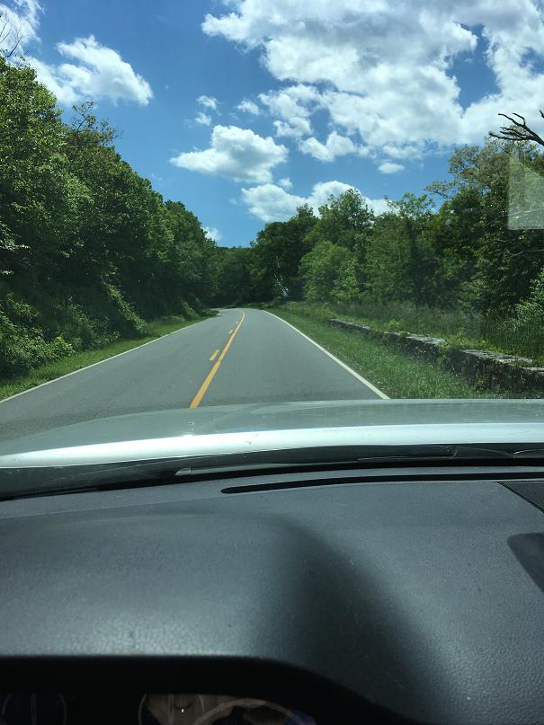
I've made the trip from suburban Washington to Vero Beach in a day many times... so many times in the years before we retired that I used to have nightmares about my life on I-95. Those trips frequently included a trailer but never one the size and weight of the Airstream which places a load on both truck and driver. Although a one-day run was out of the question from near Charlottesville, a two-day run was not. We considered several spots to end day one of the dash and finally picked the one that we had planned to hit on Sunday night anyway. That is here at George L. Smith. Just to give a sense about the drive and driving in rain on any day, think back to yesterday's posts and the beautiful overlooks and Monticello in the sunshine. Now here's what today's views were on the highway in the Shenandoah Valley (add 2000' of elevation into the clouds to imagine what Skyline Drive would have been):


If you recall yesterday's post (which was posted just before I started writing this one since we had zero internet last night) I talked about the tedium of driving Skyline Drive. I'm sure the continuation of our trip along the ridge would have delivered many wonderful surprises on a good day, today was not that. The prospect of climbing back up the mountain then driving 35 MPH in rain and fog past overlooks that offered no look worth fussing over was not drawing either Mrs. C' nor I. Instead of driving in the thick of the clouds, our route included I-81 past Mrs. C's ancestral family home in Staunton, Virginia and later Blacksburg where her ancestor's grandsons (all of whom carried the family name "Black") on another branch of the family donated the land to form the town and the university which is now Virginia Tech. Of course we waved as we past. Then to I-77 through Charlotte, North Carolina; I-20 through Columbia, South Carolina and Augusta, Georgia (home of the Master's golf tournament). The we slipped onto state roads and eventually county routes and slipped into our camp site just after 5:00. That's 8+ driving hours at speed limits. A bit longer for us. 515 miles closer to home with 417 still to go tomorrow. Here's what today's jaunt looks like as Google sees it:

So, I'm sure you are asking your computer screen "Silver Cliche', tell us what wondrous sites of America you saw and what things you did in your travels today!". Well, Campers, when you drive over 500 miles with a big trailer behind, in the rain, for over 8 moving hours you do and see almost nothing. I think at one point I caught Mrs. C' counting the posts on the guardrails to see if the State of North Carolina or South Carolina puts more posts per mile. That's bored. What we did was drove, ate (while driving... thanks to the rolling snack bar we pull behind the truck) and pumped over $100 of 87 octane into the trusty Tundra (thank goodness she drinks the cheap stuff... because she drinks a lot!). One thing that we did see was unique in all of our highway driving both before and with the Airstream. Hidden right behind that alternate route marker on the map above and right about where the "2" is the "8 h 26 min" sign is where I-77 exits Virginia. The last town in Virginia is Fancy Gap. This is where the mountains end and the coastal plain begins which means there is a big elevation drop. Well, big by eastern state standards. In this transition zone along I-77 there is no fixed speed limit. Signs warn you that this is a "variable speed limit" zone. The current speed limits are posted on a series of signs that are basically large flat screen TVs (or maybe small scoreboards from NFL stadiums... or maybe it's stadia... whatever... I'm not doing that research right now). Today we were zooming along at the posted speed of 65 MPH aided by the grade which was 4 or 5% (not enough that I needed to help the 8 brakes on the rig by downshifting). The speed limit dropped by the mile from 65 to 55 then 45 and eventually 30 MPH. Yes, 30 MPH on a perfectly good interstate with gravity working in your favor. You don't believe me? Here's a pic Mrs. C' took at that spot:

Within a half mile that same view looked like this:

 Amazing. Presumably on "nice" days they leave it at 65 all the way down.

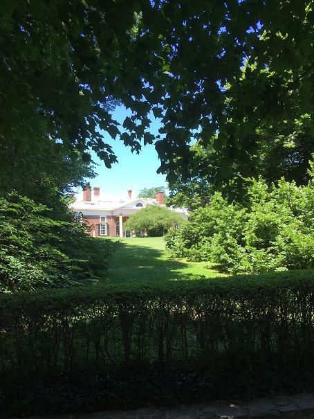
So that's it. One more night and one more driving day left in our trip. If you have been with us for the whole ride, you may recall that I called this the "places revisited" trip. We visited lots of folks, all for at least the second time and tonight marks the last place revisited since we came back here to reprise our visit from the fall of 2015. On that trip we didn't know that the attraction here is the massive cypress swamp (which starts about 25' from where I am sitting at this moment in the trailer). I'll close with the pic I took on our earlier visit and with the hope that tomorrow morning brings this type of sunshine so I can try to better this shot:

 (I call that one "Two among many"... although I was thinking of Mrs. C' when I named it, it applies to many of you, too).

I may write an epilog to this trip, but it won't be tomorrow night. If I get home and find there is no muse there then this might be it until we hit the road again. I'm not sure when that might be, but we'll let you know whenever it is.

Thanks for following along and sharing our adventures with us!

Later...

SC'

Mr. Jefferson will see you in his study, now.

Evening. Campers! It's Silver Cliche' with you again tonight… or the night before last since I have no internet here in the wilds of Virginia and you won't read this until Tuesday at best. Tonight's report is being filed from Sherando Lake Recreation Area near… well… I can't tell you since I don't have internet and that's the tool I use to look up facts like “what's near wherever the heck we are?”. I feel totally confident saying where we are not… that's anywhere with a cell phone tower. I can also say we are west of the Blue Ridge Mountains, east of I-81 and south of I-64. If you have an atlas, or internet access that might give you an idea.

So, I owe you some pics about Skyline Drive. We have traveled about 75 miles of it so far. As I mentioned last night, it is an impressive road built by out of work Americans during the years following the Great Depression almost 100 years ago. These folks received employment through a program initiated by Franklin Roosevelt as part of the “New Deal”. That program was called the Civilian Conservation Corps. The road is impressive for the fact that it truly follows the spine of the Blue Ridge range. How do I know this? The key indicator is the fact that overlooks alternate between the left and right sides of the road and are equally impressive. Roads that run along the side of a mountain only have overlooks on one side. A byproduct of the route along the ridge is that there isn't a straight section to the whole darn thing. I bet the longest straightaway we've been on in those 75 miles is 100 yards. The other thing it doesn't have is width and sometimes shoulders. This combination of curves, ups and downs, narrow lanes (I'm thinking the lanes are 10' wide and we are 8'6”… precision is the byword when driving Skyline Drive) and no shoulders makes for challenging driving even at the 35 MPH speed limit. What do you see on Skyline Drive? Well there' a whole lot of this….


And this….


But sometimes this…

or this...

 (remember, that's a panorama the two wall sections are actually straight... the picture shows what you would see if you stood in one spot and pivoted 180 degrees)

or even this...  


Note, that one includes the rarest of all Silver Cliche' photo features... a human being. That woman was drawn to the giant Queen Anne's Lace that were growing in the field. They had blossoms the size of dinner plates or maybe even garbage can lids. She moved on them so quickly that I'm thinking of gluing a Queen Anne's Lace to my head to cover the bald spot and attract attention to myself. It's kind of like when I tie a bone around my neck to get the dog to play with me. She graciously shared a pic with me to share with you here:


Every 10 miles or so along Skyline Drive is a major facility like Skyland where we are lunch (presumably named because it's where the sky meets the land, although by that definition everyplace is “skyland”… even Death Valley) or Big Meadows where we camped last night.

This is the third trip we've planned to follow Skyline Drive and the first we've actually executed. The first was scrubbed on account of weather. The second was scrubbed on account of having a rambunctious 10 year old added to the trip which drove a more direct schedule. Now we are here. After 30 miles of what you saw in the pics above, the novelty had worn off. After 50 miles tedium set in. After 70 miles the thought of driving off one of those overlooks started to sound pretty good. After 75 miles we concluded it was time to explore the valley below which just happened to contain Monticello, the home of Thomas Jefferson.

So after an hour and three quarters of driving this morning we reached Monticello. I'm thrilled to report that we had the right day for it. Temps in the low 80's, dry, clear, in a word, perfect. All I could think is “if I could bottle this and take it to St. Croix Falls, Wisconsin I could make a frickin' fortune!”. I'm thinking that when people from Wisconsin come to Monticello they don't even notice the house. They just say “I didn't know weather could do this!”.

Anyway… Monticello. Like George Washington's home, Mount Vernon, Monticello is not owned by the US Government. It's owned by a private, not-for-profit organization. That makes it very different from other national landmarks and treasures you might visit that are owned by the Feds. The first thing I noticed was on the approach to the property. You may already know (although, I didn't) that Monticello means “little mountain” in Italian. I hope you're proud of yourself for knowing that… don't be so smug… it makes me feel undereducated. Naturally, the trip to get there is up hill. If the government owned this national treasure (actually, a world treasure… Monticello is a UN World Heritage Site just like that crazy dirt mount we camped near in Louisiana at the start of this trip) they would have used eminent domain to claim all sorts of adjacent property and rights-of-way to create a 4 lane highway into the parking lot. That's not how it is. The two lane, winding road from the nearest state highway is a shorter, less navigable version of Skyline Drive. The spacious 10' wide lanes on the mountain are about 9' for the last two miles into Monticello. Far from dissuading the visitor, this gave me a feeling of what it must have been like for visitors in Jefferson's day to make the trip from Charlottesville up his little mountain on a narrow winding road. Given his stature as a statesman, philosopher and scientist, this was truly a journey to the top of the mountain for those seeking enlightenment in the early 19th century.

The other aspect of Monticello being in private hands that was striking was the fact that our National Parks Senior Pass didn't work there. “That'll be $26 per head, please.” Gulp “Thank you”. Maybe we should have waited until they made it into an IMAX experience and saved $11 each. Oh well, we were there already. From the parking lot its a short walk to the visitors center. From there shuttle buses take the groups of 25 the last half mile to the very top of the hill where the home is situated. It was worth it. Jefferson chose a beautiful little mountain top on which to situation his masterpiece. It isn't the tallest peak in the area, but it is high enough and far enough removed from other hills to offer inspiring views. Then one sees the house itself. Here is the first view we got as we exited the bus. One can imagine that a visitor who had ascended the mountain might have had a similar first view over 200 years ago:


Although the tour is described as “self guided”, the house is smaller than it looks on currency and the groups of 25 are generally herded through each room on the first floor. At each stop a docent tells the story of how the room was used (they ate in the dining room!). No photography is allowed in side the house. The second floor is only open for a few tours a day to those paying a surcharge (cha-ching!). My interest was in seeing the place and the exterior, and Mrs. C's interest was in getting back on the road. We skipped the extras. Here is the shot I came for. Its taken from the lawn on the opposite side of the home from where the initial shot was taken. To get this view, one must pass through the home (or around it) to the grassy area outside the major living space on the first floor which is the parlor located in the middle of the home on the side you see below. Jefferson's private space (library, study and bedroom) are on the right side. The family spaces (e.g: dining room) are on the left. The green louvered box on the corner is repeated at all four corners and contains a semi-outdoor room which must have been a blessing in the hot Virginia summers when shade and moving air would have been essential for comfort:

The hilltop location affords inspiring views as I mentioned above. Here is one taken from the area outside Jefferson's private wing:

It was well worth the trip. In addition to statesman, philosopher and scientist, I can suggest you add “architect” to Jefferson's list of talents. The house feels innovative even today over 200 years since it's construction. Little touches abound (e.g.: his bed in an alcove between two rooms, closets that had light shafts and ventilation, triple sash windows that could open tall enough to become doors when the weather was suitable) but its the flow of rooms and the way each was suited to its specific task that would have made this a tremendously livable home.

After our tour we had lunch of our own creation in the trailer in the Monticello parking lot. We called it “dining with the Jeffersons” although it was more “Movin' on Up” than “Declaration of Independence”. It was another 45 minute drive to the campground and we were camped for the day by 2:30 on a beautiful early summer day.

Tomorrow we press farther south.

Later…

SC'

Saturday, June 3, 2017

A Cliche' in his natural habitat

Evening, Campers! It's Silver Cliche' here with you again tonight. This report is being made from Big Meadows Campground about a mile off Skyling Drive in Shenandoah Natinal Park near Stanley, Virginia.

So, after 10 nights of visiting friends and family (and a healthy thanks for hosting us goes out to Mr. & Mrs. Buff in Buffalo, my mom and dad in Pennsylvania and our oldest daughter and her clan in Maryland... I hope you're all saying "we'd love to have that giant silver thing in our driveway again" and not "what were we thinking????") we are on the road again. Frankly, we are not used to so much good friendship and continuous good food when we travel. It's taken a toll on us... or at least our waistlines. We are now back to simple fare and having only each other, the roads of America and Romeo the wonder puggle for companionship.

Tonight we have nothing but what the trailer provides (onboard water, propane and two batteries) and a sketchy internet connection from some Verizon Wireless tower that's probably 10 miles away and overloaded with Saturday night visitors to the  Shenandoah region. I have some pics to share with you, but I'll post them the next time I have a reliable internet connection. As I shared last night, this morning included a full restocking and trailer prep to get back on the road, so,we have plenty of food to choose from. The weather is delightful and we are on the last leg of our trip home.

Having lived in the Washington area for 18 years, it's easy for me to forget the history and charm of the distant suburbs. That's where today's route took us. We pulled out of the campground at about 11:45 road-ready. We the option of South then taking the Capital Beltway (yes... that "Beltway") and heading into Virginia. Those of you who've experienced the Beltway would join me in asking "are you insane?". We opted for the slightly longer drive through West Virginia and down the Shenandoah  Valley.

We headed north on I-270 passing the Monocacy National Battlefield. We lived only a few miles from there for 5 years. The battle there took place on July 9, 1864 -- a year and a week after Gettysburg. It was part of a plan by the Confederates to attack Washington from the north and cause the Union Army to pull troops from elsewhere to defend the capital. The South also wanted to disrupt the presidential election of 1864 (and you thought 2016 was the first time a foreign power tried to use a sneak attack to alter a US election!). America's first railway - the Baltimore and Ohio -- had a major junction at Monacacy which had a Union garrison to defend it. 15,000 Confederates moved north up the Shenandoah Valley, turned east and moved through Frederick, Maryland then turned south to attack the garrison which had been reinforced to a total strength of 6,500 Union troops in anticipation of the battle. Beyond Monocacy, the Confederates saw a clear path to Washington to the south. By then end of the day there were nearly 2,000 soldiers killed or wounded. By the carnage standards of the Civil War this was a modest battle. By any other measure it was an appalling waste of life. The South technically won the battle since their larger numbers overwhelmed the Union and they owned the ground when the sun set. However, the Union efforts were successful at delaying the advance... just successful enough that the Union had time to move troops in the path of the Confederate advance and defeated the same Confederate troops three days later sending them across the Potomac to Virginia. That's the kind of history that the ring 30-50 miles from the US Capitol dome contains.

We reversed the path that the Confederates took to reach Monocacy. On the way we passed Frederick, Maryland; Burkitsville, Maryland (site of the "Blair Witch Project"... ok, not historic, but memorable to some); and Sharpsburg, Maryland site of the greatest carnage in a single day in American military history, the Battle of Antietam. Then we crossed the Potomac at Harpers Ferry, West Virginia. History drips from this little town including a seminal event in the run up to the Civil War... the raid on the US Arsenal there which was led by John Brown. We've crossed the Potomac there many times. Today as I looked from the bridge into the water below I realized that the River is turbulent, cold and not very deep. It never occurred to me until today what a fine metaphor it makes for the larger city on its banks 50 miles downstream.

The trip down the Shenandoah Valley was smooth and easy. Small towns with old brick buildings  interrupt the landscape which itself is a mix of ancient farms set on beautiful rolling land and more recent homes and businesses that suggest life slightly above the poverty line. After about an hour and three quarters we entered Shenandoah National Park at the northern end of Skyline Drive. Our National Parks Senior Pass saved us from paying the $25 that the young schmucks were shelling out! " Who ya callin' old and slow now, punk?!"  Skyline Drive, and much of the Park is the work of the Civilian Conservation Corps  from the "New Deal" in the 1930's. We've seen their work all over the country. The road rises from less than 1,000 feet above sea level to nearly 4,000. It bobs up and down along the ridge of the Blue Ridge Mountains and has more overlooks than an all girl marching band on parade past the dorm of a boys school. I'll have pics tomorrow... of the overlooks, not the marching band. We ate  lunch at the restaurant at "Skyland" in the park then headed on to our campsite at Big Meadows.

Tomorrow we may stick to our plan of following Skyline Drive and the Blue Ridge Parkway, or we may divert to see Monticello which is not far off the path. Stay tuned and I'll give you an update in the next report.

Until then...

SC'

Friday, June 2, 2017

I need a new calendar... or memory

Evening, Campers! It's Silver Cliche' here with you again and still parked at Little Bennett Regional Park Campground in Clarksville, Maryland. No, we didn't suffer a breakdown that has disabled our planned progress. When I wrote the other night that I was taking a few days off and would rejoin you tonight from the next stop on our journey I was thinking that our plan was to shove off on Friday. I was wrong. Our plan has always been to leave tomorrow. However, a commitment made is on that must be honored, so here I am writing tonight.

While here in Maryland we've been visiting our daughter and three grands. I've had the honor of walking a princess to school any morning I want... a soon-to-be-eight-years-old princess who is wrapping up the second grade. We've also had the honor of doing chores and home improvement projects since our daughter is planning selling the house they are in. We'll be sad to leave and so will our daughter and granddaughter. The teenage boys will probably look up from their screens in a day or three and say "did Mimi and Grand Dad leave?".

This gives me a chance to talk a bit about trip prep. We've been off our usual travel schedule for 10 days now. Although we've repositioned twice, we spent 4 nights in Buffalo, 1 in Pennsylvania and 5 (including tonight) here in Maryland. In each case we were visiting people, not camping and sightseeing. When we visit we don't shop to fill the fridge, we don't use what we already have on board and after about four days our morning routine includes asking "what is it that's stinking up the fridge?". So by now after 10 days of socializing it's time to restock.

The morning routine will include an early trip to our daughter's house so she and Mrs. C' can hit the big annual volunteer firefighters flea market. I'll do the last of the Mr. Fix-it chores on the list then head to the grocery store for supplies. It's a full recharge on fruit, vegetables, cold cuts, bread, dairy... the works. I'll head back to the campground (it's about 10 or 15 minutes drive), load the supplies on, do a bit of cleaning up, secure everything for travel, top off the water tank, hitch the trailer to the truck, stop at "ye olde dump station" and return to our daughter's house. By lunch time we should be rolling. 

Tomorrow night's stop is Big Meadows Campground on Skyline Drive in the Shenandoah National Forest near Stanley, Virginia. For the next several days we'll pick our way slowly southward along Skyline Drive then it's North Carolina cousin the Blue Ridge Parkway through the Blue Ridge Mountains and eventually into Cherokee, North Carolina.

Until tomorrow!

SC'

Tuesday, May 30, 2017

Slow, wet news day

Evening, Campers! It's Silver Cliche' with you again tonight and again tonight from Little Bennett Regional Park Campground in Clarksburg, Maryland.

I really don't have much to report tonight and took no pictures today. We are here in Maryland visiting our oldest daughter and her three children. That entails helping around the house... I walked our 7 year old granddaughter (the only girl of the five grands... so naturally she's nicknamed "Princess") to school in a cool drizzle. Mrs. C' and our daughter had "girl things" to do, so I offered to stay home and get started on the to do list. That allowed time for two naps (I've been behind quota this trip) and considerable time on ancestry.com.

I have not written about ancestry since our stop in southern Indiana two years ago to search out Mrs. C's parents home turf. Since then I've dug deeper and deeper. Mrs. C' and I have both done the Ancestry DNA test and we know a lot more about where we came from. It turns out that sheds very little light on where we are going, except it allows us to know when we are in places where our ancestors have been. For example we camped two years ago in Russell County, Kentucky within miles of the place where two branches of Mrs.C's family emerged from the colonial woodlands. Over this coming weekend we'll pass Staunton, Virginia where another group of her ancestors including a Presbyterian minister named Samuel Black lived. I think and write a lot about American history and geography as we travel. Genealogy adds another interesting dimension to these trips.

Many of my ancestors came from Germany and Wales. While we'll never visit their home towns with the Airstream, I can learn about them from here. Today I was working on a particular ancestor who was born in Glamorgan, Wales in 1885 (+/- a year). His name was John John. No, that wasn't his cute nickname like JFK's kid. That was his actual, full, name. Creativity may not run deep in the Welch culture. We know that the Johns (the family name, not the man's  given name) lived in Glamorgan which is the state (they call them "shires" like in "Lord of the Rings"... no, that's,not to be cute either... Tolkien stole,the,idea from the Welch) in the southeast of Wales. The action in our family plays out in an area centered on the town of Pontypridd. If you have never been exposed to Welch place names you need to brace yourself. A map of Wales looks like the aftermath of an explosion at a consonant factory. The Welch prefer not to use the word "explosion" since the south of Wales is dotted with coal mines and in the days of my ancestors living there the things were going up on a daily basis and taking coal miners with them. The life of a Welch coal miner at the turn of the last century was so cheap that they sent a miner down with every canary to try and get the bird out alive if the place blew up. It seems it was hard to find birds willing to work the mines. Anyway, besides Pontypridd, local place names include: Senghenydd, Eglwyslian, Llwyncelyn, Pwllypant and Merthyr Tydfil. Oh... and Pen-y-coedcae. And Ystrad Mynach, Cwmfelinfach and finally Ynysybwl. They tried to create a Welch version of "Wheel of Fortune" but on every spin the players would say "I'd like to buy a vowel, Pat". It didn't work. If you want a mind twisting experience, Google "spoken Welch" and pick a YouTube video or two from the list. It sounds like a blend of Italian, Russian and Klingon to me. Anyway... back to 1885 in just the shire where the Cliche' family comes from there were about 25 lads named John John born in 1885. I told you creativity didn't run deep. By the time they were 11 they were working carrying picks and shovels below ground... or maybe a canary. I think I finally found my man JJ. He was on a ship headed for New York. I knew we came from smart folk.

So I think I'll take a couple more days off until we shove off for the final leg of this journey with a trip through the Blue Ridge Mountains, South Carolina, Georgia and home (where it may, or may not, be rainy but it won't be cold). That trip starts a Friday. I'll see you then!

Later...

SC'

Monday, May 29, 2017

More rain followed by showers then drizzle then pounding rain then mist

Evening, Campers! It's Silver Cliche' here with you again after a five day hiatus. I've enjoyed some time off and I hope you have too. Wait a minute. That doesn't sound right. I hoped you missed our reports from the road and are happy I'm back at the camera shutter and keyboard!

So, when I last wrote we were sitting near the shores of Lake Erie in Ohio and looking forward to visiting our oldest, dearest friends up the Lake in Buffalo. We awoke on Wednesday morning and it wasn't raining! It was just grey and cool. We headed east on I-90 for the easy 2 1/2 hour drive through the "Erie Triangle" of Pennsylvania and into the far southwestern corner of New York. If you are not familiar with the Erie Triangle, it's the piece of land that looks like a chimney rising from the north west corner of Pennsylvania. In the early days of our nation this 300 square miles which today includes Erie, Pennsylvania belonged to the Iroquois Confederacy. The nascent Federal Government considered all claimants from the states (including claims by New York, Connecticut, Massachusetts and Pennsylvania) and brokered a deal buying the land from the Iroquois and selling it to Pennsylvania. The Iroquois were paid $3,200 for the land. The government also paid the Seneca nation $800 (not the last time the Federal government would pay a bystander). Then Pennsylvania paid the Feds $152,000 for the same land. If only our current government knew how to make deals like that! Today that land is criss-crossed by pavement and large portions are covered in grape vineyards. It was a pleasant drive.

Anyway, I digress. Buffalo. We arrived in the very early afternoon, settled our rig in for a few days of urban camping and proceeded to get reacquainted with our old friends under a warm, blue sky with lunch outdoors. That was the last time we would see the sun in Buffalo for three days until we were hitching up to leave. In between those exposures to old Sol, we ate, shopped, ate more, went sightseeing, visited, ate again, watched "Naked and Afraid", ate again, shopped some more, watched "Iron Chef" and "The Great British Baking Show", drove past our old houses, ate some more and finally stayed in and ate. We finished with pancakes on the morning of our departure. I don't believe I have ever written about the importance of pancakes on a journey like this. One day I should go deep on that subject. 

Through all of that, the thing we most focused on was architecture. Buffalo grew up in the early decades of the last century. Its position at the end of the (then) navigable Great Lakes made it a transportation hub. Where transportation flourished, industry followed. Where industry took root, wealth followed. Buffalo was a very wealthy city and the remains of that era have been lovingly cared for in vast areas ever since. I think the core residential areas of the city look better now than they did when we moved away from Buffalo in 1984. I hope to look as good as the City does when I'm 110. At the same time Buffalo was reaching its high point of success, Frank Lloyd Wright was reaching his. It's not surprising that the two would come together. When we were last in Buffalo I wrote about the Darwin Martin house which is a Wright masterpiece and is finishing up a restoration costing tens of millions of dollars. On this trip we focused on other Wright works in the area including the Elizabeth Martin (Darwin's wife) summer house in Derby, New York about 30 minutes outside the city. This house is known as Graycliff. We first learned of Graycliff in about 1999 when it came up for sale. We went to see it knowing it was under a conditional contract with a group to be known as "The Conservancy". We told ourselves we were looking with the notion of trying to buy it since it was priced at only $500,000 and we thought that was a steal. In reality, it's not clear how we could have put a deal together, but it was fun to think about it. So, the Conservancy did complete the purchase and has spent almost 20 years and many millions bringing it back. The house sits on 8 acres of lakefront  bluff. Here are a couple of shots on a grey day:

First, the view approaching the entrance of the home. Lake Erie is in the background and about 80' below the ground level at the top of the cliff where the house stands:
 
 And two interior shots from a room on the back of the house that we might call the living room if it was in our house. As one approaches the space, it is quite dark with a stone floor, stone wall columns and limited wood work, but an enticing corner window with ferns for a window sill:
 When the magnitism of the window has completed its attraction, the view through the window includes the grounds and the Lake:
 That corner window became a Wright trademark and was widely used in homes that followed including Fallingwater outside of Pittsburgh.

Buffalo also includes Wright designs that were not built in his lifetime. One is a gas station in the Transportation Museum. The other is this open air mausoleum:
 Each of the "steps" is actually two final resting places. It was simple and peaceful. The setting beside a quiet pond was even more tranquil and prompted reflection.

To balance the splendor of so much Wright, our host (you remember "Buff" and "Mrs. Buff" from our last visit to the Nickle City... right?) took a detour after dinner one evening in East Aurora. We stopped in front of a national landmark... the home of Millard Fillmore, 13th President of the United States. In an effort to be kinder than history has been to "Old Mill", let me say that his home was as modest as his accomplishments in office. Later this trip we will probably tour Monticello, home of the third President, Thomas Jefferson. I see a theory emerging that the homes of Presidents may be an indicator of their success in office. More impressive home = more impressive accomplishments as President. To confirm or refute that theory, all I need is 3 1/2 more years. Check in with me then.

After a couple of days in Buffalo, we moved on to the Pocono Mountains in northeast Pennsylvania east of Scranton. The day was warm and partly sunny as we rolled across western New York, crossed the Southern Tier through Corning, Elmira and Binghamton and down the Susquehanna Valley to Scranton then east. We arrived at my folks house and had a wonderful visit, fantastic dinner prepared by my brother-in-law. We woke up to rain. So... we ate some more. With more than a little encouragement and supervision we managed to snake the truck and trailer down the steep, narrow driveway this morning and continue heading south.

A day that started in the low fifties and rainy peaked about the time we arrived in Frederick, Maryland in the low 80's and sunny. Such a nice day can only mean one thing for us... rain is on the way. However, we have our oldest daughter and three grand kids just up the road from where we are camping, so whatever the weather we'll be busy all week while we are here in Maryland.

So, that's what's been happening. Stay tuned...

 Later,

SC'

Tuesday, May 23, 2017

The 1,000 mile detour is almost over

Evening, Campers! It's Silver Cliche' here. The states keep ticking by and tonight we've advance our silver game piece one more step along the path... that means we have moved on from Indiana and into Ohio. Specifically, tonight we came to rest at Geneva State Park in Geneva-on-the-Lake, Ohio near the northeast corner of the Buckeye State.

Finally we've reached a state where the nickname has a clear meaning. The buckeye is a tree that produces a fruit similar to a horse chestnut. That's pretty clear. What's less clear is why a state would accept a nickname like that. Oh well... at least it's not a Hoosier.

So, not much to report today. When we plan these trips there are clear points along the way that are the payoff for days of driving and weeks away from home. Whenever possible, we look for interesting places to connect the dots with a day or two drive between them. This trip already had some long, dreary stretches. This one has stretched out to be even longer than expected thanks to the rain and cold in Wisconsin and northern Michigan. So, for the past three days we've covered over 800 miles and have just 160 to go to our next intended destination.  Here's a summary of the detour thus far:

 And thanks to Google, here's a picture of the park including an arrow I put on to show our specific campsite. We are about 1/2 mile from Lake Erie at the top of the pic and when I booked this site I didn't realize there was a golf course through the woods behind us. I guess we should prepare to be awakened by the sound of cursing in the morning. Darn.


 So, today was all about Ohio. We entered the state shortly after pushing off from Pokagon State Park, Indiana and we almost reached the Pennsylvania border when we set down here in Ashtabula County. There was a steady evolution of the things that make Ohio... well... Ohio... as we moved east across the top of the state. We started in farm country. When we jumped off the interstate for gas we got a closer look. The pride and tradition of farming shows here. Small, white, simple farm houses are typically dwarfed by barns that were once painted red and are now a faded, chalky brick color. The size of the stand of trees that surrounds any given farm and its out buildings speaks to the power of the winter wind coming off the lakes and to the age of the specific farm. None are young. On a state road we even saw a warning sign with an Amish horse and carriage on it. Farming is old and deep here... and just reawakening for the season as evidenced by the numbers of tractors traversing the fields and the lack of green shoots in the fresh furrows that went on beside the interstate for an hour or more.

The first thing to displace farmland along the roadway was large agribusiness. I have no idea what the masses of silos and buildings with steam billowing from various openings did. Canning? Maybe. Whatever the purpose, these complexes were the next step up in the "food chain" from the farms we had seen. You and I are at the top of the chain thanks to a maze of transportation, warehousing and supermarkets. As we passed Toledo and Youngstown we saw industry. Not quite as old as the farming here... but close. Some modern factories, some a bit older (including one showing the passers-by on the interstate a shiny new pickup they had assembled recently) and some downright ancient from the era when manufacturing meant molten metal and flying sparks. The Great Lakes region was instrumental in the dawn of industrialization in the US and the pieces that remain from that time look like something Tolkein would have described as a place which a hero had to enter and later escape to save civilization. After that came a mishmash of orchards, vineyards light manufacturing and distribution businesses. It occurred to me that all along the route yesterday and today I watched an unusual vehicle moving in the opposite direction. Both the Ohio and Indiana Turnpikes allow triple trailer rigs to travel. These are a single tractor pulling three trailers. These beasts are more than triple our length. I've seen double trailer rigs for years... but never triples and the sheer numbers were impressive. These are reminiscent of the "road trains" that cross central Australia. Finally came the beacon of northern Ohio... Cleveland. We drove directly through downtown and I can tell you that the heart of rock and roll is still Cleveland and the heart was beating strong in mid afternoon on a Tuesday in May. From there it was 45 minutes following the Lake Erie shore to get to Geneva on the Lake.

So, 2 1/2 hours tomorrow and we set down for a few days at the home of our dear old friends for some "urban camping". You may remember when we last visited them over Labor Day 2015. From there we'll head to northeast Pennsylvania then to Maryland to visit family before starting the last leg home from Maryland to Florida via Virginia's Skyline Drive and North Carolina's Blue Ridge Parkway (a piece of which we covered last year making us anxious to see the whole thing).

I'm going to take a few nights off here. Hopefully I'll have opportunity and weather to capture some pics in those places so I can give you fewer words and more images. Or maybe the weather we've been running from will catch up with us and drown the photo ops. I'll let you know when I start writing again in a few days!

Later...

SC'

Monday, May 22, 2017

Hello Muddah, hello Faddah...

Evening, Campers! It's Silver Cliche' with you again tonight and (drum roll please...) from somewhere other than Wisconsin! Yep, tonight we've landed in beautiful Pokagon State Park near Angola, Indiana in the northeast corner of the Hoosier State. I say "beautiful" because after 4 nights in cold, wet Wisconsin I might have said "we are in beautiful Hell!" because I hear at least it's warm and dry there. After Wisconsin, anything qualifies as beautiful.

For the first time in over a week, the day broke for us with a brilliant, clear light shining from the sky. It brought illumination, warmth and, most welcome of all, hope. We saw some other campers out around breakfast time. From their mannerisms I would say they were locals. I say this because their cowered and trembled when they saw the light in the sky. It reminded me of the scene from "2001 A Space Odyssey" where the apes encountered the monolith. We explained to them that we come from a place where that light is seen often... and worshiped... we even nicknamed our state after it. They seemed somewhat calmed by that news and began grooming one another. We knew it was time to leave.

I was a bit disoriented by the sun. After taking advantage of the warmer morning to trim by hair and beard (there is a helpful trick to this process on a cool morning... when the sun rises perpendicular to the Airstream it is possible to stand on the sunny side of the trailer and get warmed both by the direct sun on one side of the body and by the reflected sun off the polished aluminum of the trailer on the other) and have breakfast, we hit the road. My last act was to take a pic out the front of the truck and another with the camera held up and pointing backward as we pulled away. Here they are...


 I think it was nice of Wisconsin to leave us those pastoral views as a remembrance. Like the song "Camp Granada" by Alan Sherman in the 1960's (the one that begins "Hello Muddah, hello Faddah; Here I am at Camp Granada")... as soon as it stopped hailing, the kids started sailing and forgot the rain... and so did we... as we sailed out of Wisconsin.

Our route took us southeast toward Chicago. Everyone knows that town as "the windy city" or "the city of big shoulders". (thanks to Walt Whitman for that one). I think we need to update those. Here in the social media age we are not so interested in descriptions as implications. I propose extending those worn out nicknames and calling Chicago "the city of lost hats" or "the city of XXL overcoats". Sorry... to many days locked in the tin can in the rain... it's like a prisoner whose been in "the hole" for too long... does things to the brain.

We did our very best to avoid Chicago proper and we succeeded. We did at one point see the skyline from about 10 miles to the southwest. Other than that it was toll booths. Lots and lots of toll booths. Fortunately, our EZ Pass worked in Illinois (we learned that at the first toll when I held out a $10 and the lady said "your I-Pass registered". Rather than saying "we don't have an I-Pass." I drove on with the commitment to not stop at another manned toll booth between there and the Indiana state line). It turns out that the last laugh was on the folks in Illinois. I just checked my EZ-Pass account. In the trip from the Wisconsin line to the Indiana line I went through seven... count 'em S-E-V-E-N... toll collection points. The smallest toll was $1.35. The largest $7.20. The grand total for the two hours we spent in Illinois was $27.50. As the old joke goes: "If that's what it costs to not go to Chicago you probably can't afford to actually go there".

If the insult of Illinois roadways wasn't enough, next we hit Indiana. Specifically, the Indiana Toll Road which is better known to travelers as I-80/90 since both of these major east/west highways share that pavement through the Hoosier State (I'm not sure if I'll get to the question of what's a Hoosier this time... whenever I see it all I can think is whether it was the inspiration for the phrase "Hoosier Daddy?"... probably not.). Is one of the strangest twists of rolls in recent memory, the State of Indiana sold the road to a private company about 10 years ago. Well, they didn't exactly sell the road itself... they leased the right to collect tolls on the road for a period of 75 years. An interesting approach. The company that leased the road went bankrupt after 8 years of operation (oops!) and what we saw was horrifying and promising all at the same time. The process of getting from Chicago was bizarre. First off, we were on I-80/90 and so was the campground. One might think that the best approach would be to stay on the same road... right? Wrong!... at least wrong in Indiana. Both Google and Waze told us to get off I-80/90 and onto I-94. We complied. After a bit of travel the instruction was to get off I-94 and onto US-20 then to some other road to get back onto I-80/90. Are you following this? Yes? Really? What, are you from Indiana??? Anyhow, getting off I-94 East and onto US-20 East should be easy, right? Well, the process is this: 1.) Exit I-94 onto US-20 West (that's right... head the wrong direction on the target road) 2.) Exit US-20 onto I-94 West (that's right, get back onto the Interstate you just exited but in the opposite direction). 3.) Exit I-94 West for US-20 East. What could be easier than that? How about reopening the frickin' exit that makes that three step process back into a single step? Here's what the Google Maps driving directions map for that maneuver looks like:
  
 With the force of a sharp stick in the eye, Google even shows the now closed exit ramp as a teaser. I've never had a simple 90 degree turn become three complete 360's until today... at least not since I quit drinking.

Anyhow, on to the bankrupt roadway. We hit no fewer than seven stretches of up to four miles each of single lane stretches of the road. Since your time is not their money, out of an excess of caution the Toll Road Company set the speed limit on those stretches as 45 MPH and the Indiana State Police put a car at every one of them. Covered wagons crossed Indiana in less time than we did. Just to cap off the pleasure of time spent on the road, two of the three rest areas we passed were closed. Romeo and I sure wished that wasn't the case. Somewhere near the end of all of that we saw an 18 wheeler on its side in a ditch off the right shoulder of the road (or what would have been the right shoulder if they had not already removed it as an "improvement"). There were two huge wreckers working to upright the rig and it appeared to have happened hours earlier, maybe even overnight. Hopefully the driver was OK. Mrs. C' asked "was that an accident we just passed?". I replied "I don't think so. It looked like another attempted suicide by an Indiana driver". 

We rolled past towns you may be familiar with including South Bend (home of Notre Dame) and Elkhart (the RV capital of the world! Literally 80% of the RVs and cargo trailers in America are made in the area around Elkhart, Indiana.) So, finally we landed at Pokagon (which is pronounced locally as po-KAY-gun State Park). The weather was low 70s and dry. I like Camp Granada much better now.

Tomorrow it's on to Ohio, then Wednesday to Buffalo.

Later...

SC'