Monday, May 31, 2021

Layin’ low in Oregon


Good morning, Campers! It’s Silver Cliche’ with you from Sunset Bay State Park in Coos Bay, Oregon.

This will be brief. We did precious little yesterday and have only a bit of bandwidth here.

Evidently, they call this “sunset” bay because it was named by a landscape photographer. I posted sunset pics from Saturday. Yesterday I took two long hikes to other parts of the park in daylight hours. Not much to show for it. 

This morning the pre-sunrise temp at the Silver Cliche’ weather station was 48 degrees but it was looking clear (a rare thing on the Oregon coast... evidently we just caught the beginning of the good weather here!). I grabbed my gear and headed out. It’s a beautiful spot in any light, but the dramatic, brilliant sunset shots win. Nevertheless, here are two fresh pics for you in this morning’s early light.


Today we will roll north couple of hours and tomorrow the same. For the next five nights we are at state campgrounds on the Pacific. Two spots for three nights in Oregon then two in Washington State... our farthest point from home!

I hope you’ll roll along with us.

Later...

Saturday, May 29, 2021

Is that picture April or August?

Good evening, Campers! It’s a tired Silver Cliche’ with you again tonight and tonight we are in Coos Bay, Oregon. Specifically, we are at Sunset Bay State Park. Coos Bay is about 1/3 of the way up the coast of Oregon from the California state line to the Washington state line.

I’ll keep it brief because we had a long day. It’s about 4 1/2 hours of driving from Fort Klamath to here as the Corvette flies. 5 1/2 as the Airstream loafs. To break up the drive we made two planned stops. I’ll talk about those in a minute.

The view out the window today for the entire trip looked like the monthly pics from the wall calendar of a chainsaw company, sometimes the pine trees were in the distance with beautiful farms and snow capped peaks:


Thanks to Mrs. C’ for that pic! Other times they were in your face like this shot:

It was a day filled with natural beauty. The constant was the trees. The trees, trees, Trees TREES! Enough with the snow capped mountains, withe water rapids, scenic vistas, curving mountain roads and rocky outcroppings. We get it... Oregon is a state of endless rugged natural beauty. And the smell of pine? The last time I experienced that intensity was when I knocked over an uncapped bottle of Pine Sol in a small bathroom. Enough already. Don’t you have any ghetto neighborhoods, junk yards or half empty strip malls here?

We broke up the trip with two worthwhile stops. The first was to meet Richard and Renata at their farm Alpacas at Lone Ranch. We connected with them through Harvest Hosts. They graciously offered to have us visit even though we were not staying the night. What a lovely couple and what amazing animals they raise. They had probably 30 alpacas ranging in age from a few weeks to 20 years. The alpacas range from a light tan (almost white) to black. Several were a “sequoia bark” cinnamon color. We clearly had a lot in common with Richard and Renata and as a result we took up far too much of their time talking about similarities in our lives and viewpoints. If we every make it back to southern Oregon (how hard could that be... we are only 5,400 driving miles and 6 weeks from home!) we are sure to ask them if we can come back and maybe shovel alpaca poo to help repay them for the time they took to allow us a glimpse of their corner of America. Here are a couple of shots of the alpacas at Lone Ranch.


Thank you, thank you Renata and Richard! We were so impressed with the business and life you have created at the ranch and by the amazing animals you raise and care for there! If we make it back we’ll bring our own shovels.

Another 45 minutes ahead we stopped at a legendary I-5 institution, the modestly named bakery and restaurant “Heaven on Earth”. They are known for their cinnamon buns. They come in various sizes from extra large to the size of a garbage can lid. Clearly they know their customer. Between the front door and the hostess stand here’s what’s waiting for you.


We rolled into Sunset Bay at about 5:30. I did get a chance to walk with the dogs and snap some pics. Here are two that are badly copied from the larger versions which are available on Flickr at https://www.Flickr.com/photos/silvercliche.  Check out the real ones!


Ok, that’s it. I’m beat... need some shuteye. Tomorrow we’ll kick around Coos Bay. Come back to see what we learn, see and do!

Later...


She blew her top!

Good evening, Campers! It’s Silver Cliche’ with you again. This is night three and our final night at the Crater Lake Resort. We have a big day planned for tomorrow as we head to Coos Bay, Oregon on the coast. Before we head off wanted to share the amazing day we had today.

It was chilly this morning. The official reading from the Silver Cliche’ weather station at 5:30 AM was 33 degrees outside. Thanks to the propane furnace in the Airstream it was a delightful 68 inside. 


The dogs and I took a walk around the campground after breakfast so they could water the trees and I could practice identifying them. Their skills are sharper than mine. They get every tree and I’m not sure I’ve gotten any. Take this specimen, for example, I’m thinking it’s some kind of pine... or maybe it’s a fir. It’s hard to say.


I figured a close up might help, so I moved in. 


I’m still not there. I’d better get a book. Or maybe a “conifer coach”. If there is such a thing this is the place to find one. There are only about 10 billion trees in Oregon. This might take awhile. Just as we tired of the desert, I may eventually tire of pine trees. But not yet.


So, frustrated by efforts at forestry, we decided to try something where our skills have been proven... visiting a National Park. Conveniently, there was one just up the road. Even more conveniently, our decision to do chores yesterday and see Crater Lake National Park today had paid off. The day was crystal clear, warmer and nearly dead calm. Ideal weather for park touring. Here is a shot of a random section of the road into the park. It’s typical of this part of Oregon and unremarkable in most ways except for a small detail which is the presence of sticks standing like 15 foot tall, rail straight, branchless trees with two reflectors at the top. This is the road that the National Park Service maintains open in the winter (most of the park roads are still not open and it’s Memorial Day weekend). This area gets over 10 feet of snow in a typical year. Those small trees are the roadside markers for the snowplow drivers.


You may be saying “Crater Lake... Crater Lake... what’s the big deal about a lake... we have lakes where I live, too.”. If you are, then cut it out... especially if you said it with a snotty, sing-songy voice. You don’t have a lake like this where you live. Generally if you want to find a lake you look downhill. The reason for that is simple. Water flows downhill. Lakes are full of water. The water got there from somewhere higher. In Crater Lake’s case, to find the lake you must look up. Our campground is at about 4,000 feet above sea level. Nearby Upper Klamath Lake is at about the same. Crater Lake is about 20 miles north of here and it’s water level is at 6,100 feet. You see, Crater Lake isn’t a lake at all. It’s a volcano that blew its top, left a big empty bowl where lava and mountain used to be and that bowl filled with water to its current level. There’s room for more water but as you’ll see in a moment that would spoil the pictures.


A volcano? Yes. A volcano. I can hear the wheels turning in your head. “So, Silver Cliche’ how many millions of years ago did this “blow up” occur?” Let me tell you... it’s thousands, not millions. 7,700 years ago. It’s so recent that archaeologists have found evidence that native people saw the blast. I suspect that the Klamath tribe members and others (or even their predecessor tribes) called that event “a very bad day to be in Southern Oregon”. There are many volcanoes in Washington, Oregon and Northern California. Mount Shasta is one. Crater Lake is the site of one that has been posthumously named Mt. Mazama. You may recall Mount St. Helens that blew in 1980, killing 57 people. Here is a map showing the names of the volcanoes that align with the Cascade range.


https://prd-wret.s3.us-west-2.amazonaws.com/assets/palladium/production/s3fs-public/vhp_img1184.jpg


It’s clearly not over. There have been scores of eruptions among those peaks in the past few thousand years. There will be more.


While I’m sure many geologists and volcanologists come here to study what happened, most visitors (including Mrs. C’ and I) come to witness the aftermath. Before I share a few shots, let me cover a topic I should have covered sometime ago. Scale. You may be tempted to look at the pics below, or better yet, the full size panoramas on Flickr (at https://www.flickr.com/photos/silvercliche) and say “Wow... beautiful... I feel like I’ve been there”. You haven’t had the experience of being here. The thing that you can’t get from even the clearest picture on the best day for photography (you’re welcome) is a sense of the size of this place. The lake is between 4 and 6 miles across. The rim of the volcano/lake is anywhere from 500 to almost 2,000 feet above the lake level. The lake itself is the deepest lake in the U.S. at over 1,900 feet deep. This lake invented “supersizing”.


So... the pics


We wrapped up at the park, headed to Klamath Falls for some reprovisioning and settled in to the trailer hood for dinner and dig-husbandry.


Tomorrow will be a long day including Alpacas, cinnamon buns and the Oregon coast. I hope you’ll come along!


Later...


Thursday, May 27, 2021

A mountain of timber


Good afternoon, Campers, it’s Silver Cliche’ with you again from Fort Klamath, Oregon. Well, it’s official... we’ve “been to” Oregon. We are on full hookups here at the Crater Lake Resort. That means water, electric and, ah hum... waste water connections directly to the trailer. That elevates us from being “a tent with benefits” and we become “a tiny house on wheels”. That means long hot showers, laundry, thorough rinsing of dishes... the works! We can even run the water until it gets hot before soaping the dishes! I like Oregon!

Here’s the scorecard:


States visited this trip: 11. New states camped this trip: 3 (NV, CA, OR)

States camped lifetime: 35. New states to go this trip: 13 (WA, ID, MT, ND, MI, VT, NH, ME, RI, MA, CT, NJ, DE)


Before:


After:


I think I set off alarm bells last night by comparing the number of things here with the “Klamath” brand to the number in the East that the Trump Organization has slapped its brand on. There was concern that I might start an arms race that could have led to “Trump” on even more objects and products to catch up with Klamath-mania in Southern Oregon. I know some of you would have purchased that Trump bathroom tissue for all the wrong reasons. For you, fear not! “Klamath” is widely used here because it was the name of the group of indigenous people who were here when settlers arrived and began giving things the names they still carry. Rivers, towns, forests,  businesses, and who knows what else memorialize the prior occupants of this land. I guess that’s a tribute... maybe? So far I haven’t met an actual Klamath person, though.


I didn’t get a chance to talk about the land much yesterday. Today was a down day for us. The weather was cool. The high temp measured at the Silver Cliche’ weather station was 64. It was mostly cloudy and we even saw a sprinkle. The National Weather Service told us that was coming and tomorrow us supposed to be better, so we plan to drive 30 minutes up the road to the National Park to see Crater Lake tomorrow. Since we were lazy today, let me catch you up on where we are.


After we passed Mt Shasta yesterday (I’m still thinking about how impressive a mountain that is) we eventually reached 5,000 feet above sea level near the California/Oregon border. We settled back to about 4,000 feet as we drove an hour into Oregon through a series of open, flat valley floors separated by minor hills. Agriculture was evident but not the “let’s feed the world” type we saw in California. Oregon agriculture looks more like “let’s feed Oregon”. 


However, that’s not the case when it comes to wood. We saw 18 wheelers that looked overloaded with 4 logs. The areas that were not cleared for crops or grazing were covered with trees... mostly conifers. They were sparse in some areas and denser in others. Some areas had been clear cut and not yet regrown. Others had clearly burned leaving only charred trunks and branches with no evidence of life left in the trees.


The most impressive lumber operations we saw were near Klamath Falls. Both were sawmills located on bodies of water. The larger of the two, which was also closer to the road we were on, turned out to be Columbia Forest Products plywood mill. It was clear that timber arrives at this mill on the Klamath River. I don’t mean by boat. I mean there was a huge system of chains, nets, and whatever-it-takes to retrieve huge logs from the Klamath River itself. How they got into the river and where they floated from was not clear, but these logs were floating. I had visions of men with spiked boots and long poles dancing log to log to keep them moving. “We’ve got us a logjam!” Maybe that’s a relic from cartoons. Let’s hope so because this business is dangerous enough. When I looked to Google for a picture to share with you, half the stories about that mill described workplace fatalities. I worked for 35 years but never swiped my badge in the morning and thought “This could be the day a desk falls in me and ends it all.”. The people who do this work so we have walls, roofs, furniture and such clearly think those thoughts. Thank you! Please stay safe.


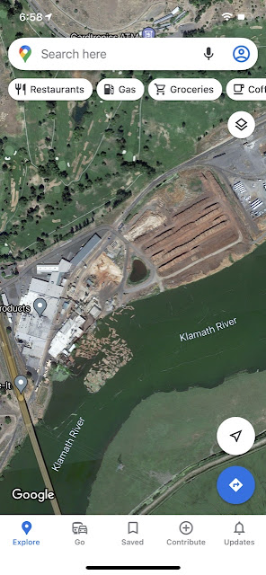
It’s clear that once the workers of Columbia snag the logs from the river that they stack them. Makes sense. Who wants soggy plywood? I was looking for words to describe the scale of the log pile outside Columbia. Football field? Nope. Aircraft carrier? Nope. NFL stadium? Maybe. Eventually I concluded the closest I could get would be New York City block 20 feet high stacked with logs. By logs, I mean entire trees, sans branches, where the bottom is 3-4 feet in diameter and the other end about 2 feet. It’s a lot of wood! And remember, wood is in demand right now. There is a nationwide shortage of lumber. That pile of wood isn’t a glut. Presumably it’s bigger if things are slow.


They say that eskimos have 45 words for “white”. (Actually, that was debunked decades ago but I needed to scrape the bottom of the barrel for this next bit.) I’m thinking that Oregonians have at least that many for “pine tree”. There are pines, but also larches, firs, redwoods, spruce and... well... 40 other things that aren’t palms or oaks or anything like that. It appears that they all grow here. I’m a bit sheepish to ask anyone about the “pine trees” to avoid exposing my ignorance. “Oh, do you mean the MacNab Cypress over there or that Western Red Cedar next to it?”. Deer... headlights... crickets... “Never mind. Do you have any DuraFlame logs? I need two boxes. Thanks.”


So after passing the plywood factory we drove by Klamath Falls, a city of 30-something thousand population. It looked good from the highway. We might stop by tomorrow for a little resupply. We drove along Upper Klamath Lake which is the largest lake “by surface area” in the state of Oregon. Evidently there is a larger lake “by volume of water” in some other part of the state and they were not ready to lose their title when Upper Klamath was formed by the damming of the Link River (yes... later renamed the Klamath River).


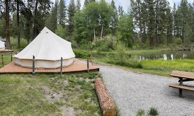
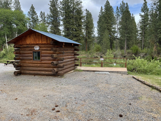
We are now camped at Crater Lake Resort on Fort Creek in Fort Klamath. Our campsite literally backs to the creek.


This is a nicely run little business. The grounds are clean and well done. They have amenities for all ages. It’s a bit pricey (seriously... like city prices) but it’s clear that they spend money to make it right. They have little cabins, “glamping” tents, canoes, etc.. The water in Fort Creek is about as crystal clear as any water I’ve ever seen in nature. Last night at dusk I could hear the elk bugling somewhere between here and the lake which is about a mile away. We were headed to a “first come first served” open parking area near the National Park for this stop but decided we needed a quiet place with more services to hunker down. This will do fine.


Tomorrow it’s Crater Lake and maybe Klamath Falls (did I mention there are not actually falls there?). I hope you’ll come with us!


Later...

Wednesday, May 26, 2021

You want some Klamath with that?

Good evening, Campers! It’s Silver Cliche’ here with you again.Tonight we’ve landed in Fort Klamath, Oregon. Under the Cliche’ Code of Conduct, we can’t add the sticker until we spend the night, so I’ll update the scorecard in tomorrow’s post.

The day actually started before the sun. We were the only campers on Caz’s MoonBeam Farm so I left the shade open on the window next to my side of the bed. I had shared the pic of the moon rising over the lavender last night. Well, this morning at 4:45 I opened my eyes to see how Zachary had managed to push my lower body out of my place in bed and into the cold, empty section of dog bed that he is supposed to occupy. I never answered that question because I looked out of the window to see the half-eclipsed moon. Thanks, Zach! Well, half thanks. I still want my space in the bed back.

Despite having a 3 3/4 hour driving day ahead of us, we were lazy this morning. Maybe the lavender calmed the nerves and clouded the brains. Or maybe it’s early onset old-timers disease. We were rolling at 11:15... back on I-5... compass needle on “N”... signs for “Redding”. We stopped in Redding to hand a package to FedEx then resumed our trip.

As I-5 nears Redding an uncomfortable feeling starts to set in. The Central Valley that we had been in and about for 10 days was wide in the south when we first crossed it. It was perhaps 50 or 60 miles of flat land between the coastal mountains and the Sierra Nevadas. In Redding you can feel that those mountains are converging and the sight of mountains ahead signals the end of the Valley.

A dramatic, distant sight begins appearing above trees and mountains to the north. It’s the snow covered, cloud wrapped summit of Mount Shasta. I’ve seen mountains all around the world. Some from the ground, some from their summits, some from the air. I have heard about Mount Shasta but was unprepared for two aspects. First, it stands alone. Unlike the Alps, the South Island of New Zealand, the Rockies, Smokies, Blue Ridge, Green or White Mountains where groups of high points are clustered, Shasta is singleton. I’ve never seen Kilamanjaro, but it is the same. So is Fujiyama. The second aspect is its height. It’s absolute height is impressive at over 14,000 feet. More significantly, the places we were driving and from which we could see Shasta the best were roughly 2,000 feet. That means the summit is over two miles above the viewing point. It’s a stunning effect! To put it in perspective, the Mount Everest base camp is 12,000 feet below the summit. While we were in the trusty Tundra enjoying cold drinks from the Airstream’s fridge, we were having the same view that Everest climbers have of their objective, 

Here are some pics Mrs. C’ snapped along the way.


We closed into Oregon at about 2:30 with an hour and a half ahead of us. The weather was nice. We started picking up the Klamath vibe. There was Klamath-this and Klamath-that. We saw Klamath Forest, Klamath River, Upper Klamath Lake (yes... there must be a Lower Klamath Lake... and maybe a Middle, too). We passed through Klamath Falls on the way to Fort Klamath. Look, I don’t know who this Klamath guy was, but he managed to put his name on more things than Trump did. I expect to stand at the intersection of Klamath Street and Klamath Avenue if we go in to Klamath Falls tomorrow.

So, long day. I’m tired. I’ll try to grab some pics around here to share with you tomorrow,

Later...

Tuesday, May 25, 2021

California ends with a bang

Good evening, Campers! It’s Silver Cliche’ with you again. Tonight we are in Corning, California on the grounds of MoonBeam Farm. Is it me or is there something eerie about being at “MoonBeam” Farm on the night when the moon’s beams are going to be cut off by a total lunar eclipse? Come back tomorrow to see if this was actually a good idea!


Tonight is night 16 in California and night 40 of our trip. As of this moment, we’ve driven 5,136 miles since rolling out of our driveway. 1,400 of them in California alone. We aren’t quite halfway through with the trip since we are targeted for 102 nights, but we are getting close to the mid point and to the farthest point from home.


Tomorrow we plan to enter Oregon, although we do have an option to stay one more night in California at a Forest Service campground near Lake Shasta. I’m thinking tomorrow’s report will show a Fort Klamath, Oregon return address. If so, our last full day in California was truly a full day and a highlight.


We started today with temps in the 50’s surrounded by cherries and grape vines at Joe and Alina’s farm in Lodi. This post is a final “thanks” to them! We felt welcomed by them, appreciated their hospitality and were enriched by the chance to see the little corner of America that they call home. Zach loved taking his morning stroll on the dusty road where the Airstream was parked and leaving his leash at home. Romeo was intimidated by the open space, or maybe he recalled the bedtime story I read him about how bald eagles are making a comeback and small pets are disappearing without a trace as the number of eagles rises. He stayed right by the Airstream door while Zack rolled in the dust, chased sticks and generally acted like a dog on a farm.


We left Lodi at about 10:00 and headed to Sacramento. Specifically, East Sacramento which is a neighborhood with the larger city. Why “East Sac” as it’s known to locals? Because we had some specific shopping objectives and a Google search showed that East Sac was where we’d fare the best.


The last 16 days have been about seeing parts of California we had never visited. We had previously been to the large coastal cities (Los Angeles, San Francisco and San Diego) and I had been to the Coachella Valley (Palm Springs). Beyond that... nothing. My image of Sacramento before today had been shaped by impressions of others... particularly from acquaintances and colleagues all of whom were from large coastal cities. What I expected to find was a cow-town with overtones of pigs feeding at the trough of state government. What we saw in East Sac was anything but that. Our first impression was the drive along city streets after exiting California 99. The neighborhoods were charming with mature trees including palms, conifers and deciduous varieties, interesting and varied houses that were lovingly maintained and an appealing variety of businesses. Now, the rest of Sacramento may be a cow-town that smells like a pig farm... but East Sac was probably the most attractive and livable place we’ve visited in 40 days and 5,100 miles... except for Vero Beach, Florida, of course! We immediately busied ourselves engaging the shopping and services that had drawn us there in the first place. They didn’t disappoint. Mrs. C’ found precisely what she was looking for and stocked up with some clothing for the next phase of the trip... and some clothing to wear back at home... and some gifts... and some jewelry. If a highlight film of her experience appeared on the 11:00 news it would have featured a voice-over track with “She shoots, she scores” and “She might go all the way”. Meanwhile I attended to family business including a swing by a local UPS Store... and all within a five minute drive. For me, Sacramento was a highlight. But time was ticking and our destination was awaiting. We rolled north again at a bit after 2:00.


As we headed north on I-5 we were still in the fertile Central Valley of California but no longer in the portion known as the San Joaquin Valley. The northern portion is the Sacramento Valley. It was equally impressive as an agricultural resource, but the crops changed. Sure, there were still acres and acres of almond groves (how many freakin’ almonds do Americans eat???) but mostly what we saw today were... what?... rice paddies? Yes... rice paddies. With distant parched hills as a backdrop, I-5 north of Sacramento is bordered by flooded fields with green shoots thick enough that one might be tempted to see if it’s possible to walk on water. This region of California produces over 4 billion pounds of rice per year. If humans could thrive on a rice and almond diet we’d all live here.


We stopped at Arbuckle, California for a late lunch. The choices were Mexican, Mexican or Mexican. We deliberated and chose Mexican using Google reviews to guide us. At 3:00, I walked in to “Mariscos el Capi” to place my take out order. This was a Spanish oriented restaurant. There was Spanish language TV on multiple screens. The menu was in Spanish with some English. The few other patrons in the place were speaking Spanish or looked like they could. I put on Latin airs to fit in. My polished performance probably would have worked better if I actually spoke Spanish and if I hadn’t chosen today to wear boat shoes with low white socks, khaki cargo shorts, a floral print shirt with a collar (untucked) and a ball cap with “Yellowstone National Park” embroidered on it. When Mexican school kids use their dictionary to look up the word “gringo” there is a picture of me dressed like that next to the definition. 


Mariscos el Capi had various forms of shrimp and fish on the menu. They also had carne asada which sounded tasty but inconvenient to eat while driving. I asked the young woman who was taking my order if it would be possible to get the meat from the carne asada in place of the fish in the fish tacos. “No, Senior” she said “We don’t do that”. That kind of answer deprives me of the ability to remain neutral. It’s a “fight or flight” moment. Today I realized I was a stranger in a strange land and I replied “Ok... I’ll have the fish tacos”. Only later did Google translate clarify that “Mariscos el Capi” means “Seafood el Capi”. C’mon, Google... translate all of the words! The tacos were good.


We arrived at MoonBeam Farm a few minutes after 5:00. We are the only RV here tonight although there is space for 6 or more. Our host Caz who owns and runs the farm opened the store for us and immediately the education began. They grow organic lavender and  loofa here. The lavender comes in many varieties for distinctly different uses. There are edible varieties for flavoring foods, highly fragrant varieties for oils and soaps and cosmetic varieties for lotions. I think Caz has more ways to prepare lavender than Bubba Gump had to  prepare shrimp. I’m not sure if she said “lavender scampi” or “lavender po boy”... but she might have! After we stocked up, Caz took us for a walking tour of the lavender patch (maybe it’s a field, grove or orchard... I’ll have to check). Several varieties are blooming now. Bees from natural colonies were plentiful. The light breeze was heavy with the scent of lavender and it still is since the plants start about 30’ from where I am sitting to write this. Caz is a lavender encyclopedia. We also saw the first loofa plants emerging from the soil. Loofa are annuals, so it will be months before they bear fruit (which looks like a zucchini on a vine supported by a trellis system based on what I learned today. Caz was a gracious host who can’t suppress her passion and who willingly shares her knowledge. She has a great website including a section on the products she makes from the lavender and loofas. https://www.moonbeamfarm.com


Here are some pics including one that I’ll call “moonrise over lavender”


So, tomorrow we continue north... shooting for Oregon, I hope you’ll join us.


Later...


Monday, May 24, 2021

Green, greener, greenest

Good evening, Campers! It’s Silver Cliche’ here. Tonight’s report is being delivered from Lodi, California in the north end of the San Joaquin Valley, just south of Sacramento.

First, I need to describe the place we are staying and how we came to be here. We are parked on J&M Farm. Our hosts Joe and Alina signed up with Harvest Hosts to allow people with self contained RVs to stay overnight on their land. We signed up separately to be able to find folks like them and connect through the Harvest Host App. We needed a place to set down in this area. I reached out. Joe responded positively. Here we are. It’s that easy.


This region grows a huge volume and vast array of crops (more on that later in the post). Here in Lodi we’ve seen two crops in abundance... wine grapes and cherries. A little research tonight told me that the area around Lodi produces more wine than Napa and Sonoma Counties combined. If I can show my snarky side and my newfound Lodi pride in one sentence I’d say “Napa is where they put wine in brochures, Lodi is where they put it in bottles.” In keeping with what we’ve seen, we are parked tonight on a dirt and gravel, road about 3/4 of a mile from the nearest pavement with a field of cherry vines (not full on trees... vines) loaded with fruit on one side and a field of grape vines on the other. That would be special enough, but there are fields of grapes, cherries and God only knows what else in every direction for as far as the eye can seen.


So, thanks Joe and Alina, and thanks to Harvest Hosts. This approach will clearly play a role in our trip planning going forward. Let me show you a few shots of their farm:


So, back to the day’s doings. We woke to a quiet campground at San Luis Reservoir. When you travel week after week, as we do on a trip like this, you feel the rhythm of campground life. A few campgrounds are busy every day... think big name national parks. Most are busy Friday and Saturday and not so much other days. When I plan a trip like this I literally highlight the national parks and weekend days, figure out where we need to be, make those reservations first then go back and fill in the weekdays. At a place like San Luis Reservoir, Monday morning is quiet. We took it slow, and left at about 11:00.


We headed north using I-5 to move along the western edge of the San Joaquin Valley. We stopped an a farm stand in Gustin, California. Well, not a “farm stand” exactly... more of a purveyor of California agricultural products. No, that’s not quite right either. Maybe “locally grown medicinals” describes it better. Ok... a dispensary. It’s legal and recreational here now. You have to be over 21 to become medicated. Fortunately they haven’t set a maximum age. When 65 year old Californians start driving like 85 year old Floridians (slow and in the left lane) expect to see age limits at dispensaries. Until then...


We traveled county roads to get to and from the dispensary and got our first “up close and personal” view of California agriculture for the day. The trees lining “Orchard Road” were healthy and ranged from tall, mature, productive to fields of saplings over a five mile stretch. The signs of irrigation were everywhere. Major pumps, canals, cisterns, plastic pipe and drip lines. Some of the trees had fuzzy olive green fruits about the size of a golf ball but shaped like a football. Here’s a picture Mrs. C’ took of one.


A little research showed that these were almonds. For the next 30 minutes or so we saw mile after mile of almond groves. Most were healthy and productive. Some were dead on the stump. Whole groves. Dried wood standing in the shape of once living trees. It told the tale of water allocation and a statewide drought. With declining water availability and rising demands from human consumption to agriculture to sustaining environmental resources there have been some losers. Dead almond trees by the acre have been among the losers.


By early afternoon we reached Stockton, an urban center with about 300,000 population in the San Joaquin Valley. That makes them big enough to have a Trader Joe’s but not big enough for a Whole Foods, evidently. Fair enough! Trader Joe’s will do. We stocked up with some stuff we’ll need in the next week or so, grabbed some lunch and chilled a bit before heading to Lodi. I was surprised to see large, ocean going ships from I-5 in Stockton. The city is 70 miles inland and there are mountains along the California coast. Fortunately for Stockton there is a gap in those mountains at San Francisco Bay. That enables large ships to sail under the Golden Gate Bridge and continue 70 miles inland to Stockton. 


So, that’s our day. An exposure to agriculture, a stop in a city and night in a vineyard.can we top that tomorrow? We’ll try! I hope you’ll roll along with us.


Later...

Sunday, May 23, 2021

Roll film. Action! And... cut. That’s a wrap.

Good evening, Campers! It’s Silver Cliche’ with you again tonight and again tonight we are at the San Luis Reservoir State Recreation Area near Santa Nella and Los Banos, California.

Whattttt? No Yosemite? I can’t share the high school prank I had planned to recreate Ansel Adams’ famous “Moon over Half Dome” using a different sort of moon. I’m sorry to disappoint. Anyway, Mrs. C’ and I talked over two options with our morning coffee. Head to Yosemite (three hours away) to spend a single night in Yosemite Valley (the heart of the most congested and visited park in the system) then drive 3 hours tomorrow or stay in place and relax. We decided to relax. Why? Well, it goes back to the purpose of this trip. It’s easy to confuse “purpose” with “focus”. The focus of the trip is the route, the completion of our lower 48 map and the many stops along the way (including Yosemite). However, the “purpose” of this trip is to spend time together doing something that we found enjoyable early in our retirement... being together on the road. Going to Yosemite for a day contributed to the focus but not so much to the purpose. Staying here was the opposite. Purpose won.

After three days of struggle I think I have a way to share the videos that have been accumulating for about 10 days.

Here are two that Mrs. C’ took on the way to see the General Sherman tree back at Yosemite:


And two I took of the big guy himself. It’s hard to comprehend the scale from the pics I posted previously. These videos help:


And one I took on the way down from 7,000’ back to Three Rivers at 1,000’ above sea level:


Assuming these work, I’ll post another video update hopefully tomorrow night when we’ll be dry camping at J&M farms, a grape and cherry farm in Lodi, California just outside Sacramento. That will be our first camping experience through Harvest Hosts which connects RVers with farms, vineyards and other folks who have interesting properties they are willing to open for overnight stays.

I hope you’ll roll along with us!

Later...

Saturday, May 22, 2021

Blogging issues... back soon

Good evening, Campers! Silver Cliche’ here... night 3 at San Luis State Recreation Area, California outside of Santa Nella. I learned today that we are also close to Los Banos, California. I learned that because we went there to buy propane at Tractor Supply (I left thinking “You know, I really would like to have a tractor.”) and to resupply at Walmart. Anyway, I’m feeling ever closer to the Hispanic people and their language after 10 days in California. Soon they’ll be calling me “amigo”, I’m sure. “Hola mas amigo” I’ll reply. Anyway Los Banos... according to my deep knowledge of Spanish (ok... according to my use of Google Translate), Los Banos means “the bathrooms”. From time to time I “go off” about place names. I’m a huge proponent of clear, honest, “authentic” place names. But for crying out loud, people, you don’t have to name your town “the bathrooms”.

Anyway, I’ll be brief tonight because I already wasted an hour or two last night and another hour tonight trying to get Blogger to accept my videos and have nothing to show for it.

After tonight we have three more nights in California. Tomorrow we’ll be in Yosemite... specifically, we’ll be in Yosemite Valley very near the Ahwahnee, Yosemite National Park’s centerpiece Lodge, Half Dome and El Capitan. Then two nights staying in Harvest Host sites. We just joined Harvest Host last week to address some gaps and rough spots in the schedule. They are a subscription organization that connects RVers with self contained units with farms and vineyards willing to allow RVers to park overnight. On Monday night we will be at a grape and cherry farm outside of Sacramento. On Tuesday we’ll be at an organic lavender and loofa farm near Mount Shasta. I understand the lavender is in bloom at this time of year and it will be warm on Tuesday. I can’t imagine being downwind from a lavender field with the windows open. As for loofa, I thought it was a sponge... as in “from the ocean”. What the hell! They grow on organic farms in Northern California??? I haven’t been so surprised since I learned that our trip runs on fermented dinosaur juice. 

Then on Wednesday, or if we dilly dally Thursday, we head to Oregon and Crater Lake National Park. Here’s a summary of the criss crossing of California that gets us from Cal-Nev-Ari, Nevada to Fort Klamath, Oregon. 


I hope you’ll ride along with us!

Later...


Thursday, May 20, 2021

A berry good place, Watsonville!

Good evening, Campers! It’s Silver Cliche’ here with you again. Tonight we are camped at the San Luis State Recreation Area just outside of Santa Nella, California on the western side of the San Joaquin Valley.


After yesterday’s windstorm on Monterey Bay things settled down overnight and the temps plunged. The Silver Cliche’ weather station clocked a brisk 39 degrees just before the sun started to warm things. Forecast high in Watsonville today... 62. Which is the same thing our digital speedometer read as we said “let’s blow this town and find a warmer one!”


Our exit took us through some interesting stuff. First, Mrs. C’ caught this pic of an unusual house which we first saw on the way in to Sunset State Beach:


A little Googling told us the story. Built in the 1890s, the house was sold to a Japanese-American farmer in the 1930s. Evidently, the population of the Pajaro Valley was about 10% people of Japanese ancestry at that time. U.S. citizens, but descended from Japanese immigrants. Then WWII came with the opening shots fired at us (you may recall December 7, 1941... at date that will live in infamy) by non-U.S. citizens of Japanese ancestry. Well, the U.S. government got confused since they all looked about the same to people from Washington, so they rounded up these citizens (including Mr. Hirahara and his family) and sent them to Arkansas for the rest of the war and took their property for good measure. I’m thinking people in other countries know this history when Americans preach about the abuses they commit against their citizens and demand that it stop based on all things that are moral, good and American! Sorry... I got a little carried away... let me stow my flag. Anyway, local folks in Watsonville somehow helped the Hiraharas return to the house after the war ended and the U.S. government ended their Arkansas vacation. Eventually the house was abandoned by the family. Again, local folk got involved and before a developer could build a 7-11 or something there they got the house accepted in the National Register of Historic Places for its architectural significance. Development prohibited! For me, this story is about a lot more than architecture. Ya gotta stumble on this stuff to hear these stories... or know someone who does.


On we rolled past strawberry fields (in Salinas it’s “Me and Bobby McGee”... in Watsonville it’s “Strawberry Fields Forever”) then we saw acre after acre of fields covered by plastic that was draped over semicircular arches. Each arch was about 25 feet wide at the base and 15 feet or so tall at the center. Inside were rows of plants that looked like grape vines. There was space between each row, a post at each end and, I presumed, a wire between each post to allow the plants to be supported. I’ve never seen covered vineyards. Why here? Again, Google provided the answer. Watsonville is home to Driscoll’s berries. Maybe your grocery stocks them. Ours does. At this time of year their farms in Watsonville produce strawberries (I showed you that last night) and... wait for it... raspberries and blackberries. Eureka! (That’s eureka the exclamation... not Eureka the city in Northern California). These were field of raspberries and blackberries. I feel a growing connection to Watsonville. These people have been making my breakfasts and desserts more colorful and delicious for most of my life.


So we rolled east through beautiful rolling hills covered with parched grasslands. We went through Gilroy, the garlic capital of the U.S.. it truly smelled of garlic there... I mean the town smells like it ate a salami sandwich on garlic toast. 


As we approached our current campground we skirted the San Luis Reservoir. It looks like other California lakes and reservoirs we’ve seen so far... way below capacity. We saw herds of elk on the hillsides above the reservoir. We continued another couple of miles and turned off the main road to get here. The campground is located on a “forebay” to the reservoir. This is a smaller reservoir fed by the larger one we had passed. It’s a holding pool before distribution and it appears to be filled. From Google Maps I can see that water is distributed from here through three channels that head in various directions.


As I walked the dogs after dinner I got a couple shots if the forebay including one of four deer just behind our trailer and campsite.


We plan to spend three nights here while it rains and gets cold in Yosemite. We are both feeling some effects of the pace of travel and relocating so often. Maybe 4 months to survey our border should have been six. Anyway, we are here now, it was 77 degrees, dry and sunny today. It’ll be nice to chill a bit.


Later...