Monday, June 29, 2015

The last from Yellowstone

Howdy Campers!

We took a day off today.

Did some trailer maintenance and cleaning.

Made a small dent in the Bison problem with lunch at the Lake House restaurant here at Grant Village.

Did the laundry (at the request of people two campsites over... phew!)

I was going to simply say "I'm taking the evening off since I took the day off, but this is Yellowstone and your faithful blogger is ready to share the news even if it finds him.

So, after dinner and while getting the truck loaded to resume travel tomorrow some passers-by stopped to chat about the Airstream and casually said "Hey, did you see the elk right over there?". So, I grabbed my camera and walked a full 100' to take these pics:


Tomorrow back on the road and off to hot weather. We hope to camp at the Medicine Lodge State Archaeological site in north central Wyoming. It's supposed to top 90 there, so we may divert for a place with electicity for AC.

Later....

SC

Sunday, June 28, 2015

Day 3 in Yellowstone

Evenin' Campers!

Another day in Yellowstone.

They tell us it's hotter than a firecracker in the western states today... But not too bad here in America's... no... the world's first national park. It started out in the mid 40s today and eventually hit the low 80s (a "Yellowstone scorcher"!) before rain showers came over us in several waves creating a beautiful, cool evening.

We stuck to our plan and got out among the critters and attractions at a reasonable hour. We left our camp here in Grant Village about 9. We were armed for the hunt... two iPads, two smart phones, a digital camera with two lenses, a 4 plug USB charger, at 100 watt inverter for 120v power, the charger for the camera battery, a laptop with its charger (for the pics from the camera... that's how we convert many individual shots into the panoramas we love to share with you) a bag of food and drink and two bicycles. In other words, just the essentials... we were traveling light like the pioneers! (Did I mention that we crossed both the route of the Oregon Trail and the Pony Express in mid Wyoming? Looking at the expanse of high plains there, one can only ask two questions: 1. How bad was it where they were that they left to face this? and 2. How did they do it?) Not along on today's trip were Mutt and Mutt who were happy to sleep the day away in our home on wheels.

Remember the description I gave yesterday of the figure eight formed by to ring roads in the park? And how we are camped at the bottom of the 8? Today we headed counter clockwise (anti clockwise for you, Chris) to the top of the lower lobe of the 8. We reached the point at which the two lobes join, a place called Canyon Village. Why, you may ask, do they call it "Canyon" village? Because for about half of the route the road follows the Yellowstone River as it plunges through a gorge that is up to 1,200 feet deep and 4,000 feet wide from rim-to-river and rim-to-rim. SPECTACULAR! We made a day out of stopping at the various overlooks, points-o-inspiration and generally breathtaking scenes. Check out the photos here (which are typically 10% of the resolution of the originals. The originals can be found on our Flickr page at: https://www.flickr.com/photos/131457232@N02/)


En route to the canyon we saw this guy and stopped to snap a few. He was easily within ear shot so I thanked him for modeling for the picture on the nickel... I also told him he was an inspiration to American men of a certain age who share his physique including a substantial midsection and undersized hind quarters. "Thanks, Bill! You make us proud!" (The guide book says they are all called Bill... Buffalo Bill I think).


Which brings us to today's musing. I want this on record here so the scientific community can eventually ascribe to me -- SilverCliche' -- the discovery of the phenomenon I am about to describe to you. May I suggest "SilverCliche' syndrome"? On several instances between Grant Village and the Grand Canyon of the Yellowstone we encountered bison. Sometimes one, sometimes herds of them. In almost every case these critters brought traffic to a standstill. I mean a standstill... in both directions. People literally stop in the lane in which they were driving, emerge from their cars, walk toward these magnificent wild creatures and begin the photographic process. At one point today in the Hayden Valley we were at a dead stop for upwards of 5 minutes and there were at least 20 cars ahead of us. We couldn't see "bison dung" from our position in line which meant we were far more annoyed at the people blocking the road than we were thrilled at the wildlife encounter. In fact, this is about the time we realized bison are a nuisance species here in Yellowstone. More on that later. Eventually, a US Park Service ranger in her white pickup truck with the logo on both doors, US government license plates and emergency lights on top (not illuminated at the moment) pulled out of line and began driving slowly down the left lane of this two lane road to see what the commotion and delay was about. I suspect that from experience she knew darn well what it was about and she was actually hoping to break up the photofest and get traffic moving again. Now, here's where the SilverCliche' syndrome kicks in. At least three cars from the line followed her down the wrong side of the road in a no passing zone just as some traffic began moving in the proper direction in that lane. The simple bison-induced rubber necking delay became a traffic snarl of New Delhi proportions! Oh yes... the syndrome. I can only imagine that the people who stopped in the first place, the people who followed the ranger and the people who pressed on through this mess do not behave this way at home. One of the cars that followed the ranger was a Honda Odyssey minivan with a family from (based on their license plate) Arizona. I bet they don't follow emergency vehicles on a call in Phoenix just because they know the hospital they are heading to is near the mall and they'll get to their shopping quicker that way. They don't. But they do here. How to explain that? Well... The SC syndrome postulates that bison emit an odorless, colorless gas (in addition to the pale green decidedly non-odorless gas that science has already documented that they emit in large quantity). This gas effects human judgement and causes a sort of bison euphoria or rapture. I have no other way to describe the human misbehavior that the mere site of a bison brings on. Remember, you heard it here first.


Back to the canyon. It's spectacular. First we headed to the south rim which has some beautiful views of both the two falls and the wild River within the canyon. The end of that road is "artist's point". Need I say more? Then we backtracked and followed the north rim. Again, spectacular views including "inspiration point". I actually reached the point of inspiration at artist' point, but that was evidently a case of premature inspiration. No more about that.

When we reached the top after many stops, walks down trails, pictures, videos, listening to endless Chinese gibberish (have I told you that about 40% of the visitors we see in the park are Chinese? You thought they were only taking advantage of the US government through Internet hacking! Wrong!) we needed a break. Fortunately, Canyon Village offered that in the form of tee shirt shops and a choice of restaurants. We hit both... hard. First the shirts then an actual sit down restaurant with a real menu. I was inspired by the morning's encounters with Yellowstone's nuisance species, so I ate a bison burger to do my 1/2 pound share to address the problem. Later I learned the bison was farm raised in Kansas or somewhere leaving the problem no closer to resolution. Mrs. C' had the turkey burger. What inspired her to pick that I do not know. We haven't seen a turkey in Yellowstone (although we did see them in Colorado or Kansas or Missouri or... oh what the hell... those states have all run together at this point... we saw one, OK?). But she hadn't seen a turkey all morning. She was just in the truck with me... hey... you don't think she... naw...

After that we meandered back toward Grant Village, the dogs and our second home. We stopped briefly at a couple of sites including the sulfur cauldron and a beautiful view of rain showers across Yellowstone Lake. As for the cauldron, I decided if I wanted to be near smelly gurgling dark water I can just visit the "dump station" and empty our waste tanks. I've had about enough of that and about enough of smelly boiling mud coming out of the ground. At my current level of exposure, I'll never forget that about Yellowstone. Any more sulfur pit viewing is pure overkill.

Tomorrow? No plan yet. Maybe we will just be lazy and stay near here. Maybe we will try to find the wily elk, moose or bear (three critters we have not seen yet but wish to). We know for sure we start the trip back to Florida on Tuesday, so tomorrow is a good time to prep and catch our breath before the next 2,500 mile segment begins.

Good night, Campers!

SC

Special Yellowstone VIdeo Update!

Here are several videos Mrs. C' took yesterday in the geyser basin area of Yellowstone. It took longer for my talents as a poster of blog content to catch up with her talents as a videographer.

The Grand Prismatic Spring:

 
The Excelsior Geyser Crater:

9technical difficulty... will try later...)

A hellish scene of boiling mud rising to the surface of the earth:


Saturday, June 27, 2015

They're looking for geysers now...

Howdy, Campers!

Our first full day in Yellowstone. So much to see here!

The day started cool, or as we Floridians say, "frickin' freezin' ". Low 40s. The trailer continues to work like a champ. We were warm inside and even the old mutt Kailey was toasty (there's a warm air duct from the trailer's furnace right by her bed on the floor of our bedroom area in the front of the Airstream).

We took time for a hot breakfast. A house specialty... "Gavin-cakes"... pancakes made with Pamela's gluten free pancake mix which we started buying during one of those "maybe he is gluten intolerant???" periods. He wasn't, but our taste for Pamela's lasted beyond the experiment and his name stuck to the tradition.

After getting ourselves and our shiny silver yurt cleaned up, we packed some food and drink, walked the dogs and headed off.

Let me update an exaggerated estimate I made yesterday without the benefit of the Internet to fact check. Yellowstone isn't the size of New England (although it feels like it). It is the size of Rhode Island and Delaware combined. It is roughly square. There are five main entrances... One each near the center of the west, south and east boundaries, one each in the northwest and northeast corners. The roads from each of those entrances leads to a pair of ring roads within the park that connect to form a figure 8. Yellowstone Lake sits along the southeast segment of the lower lobe of that figure 8 and we are on the shore of Yellowstone Lake at the very bottom of that road.

To start our exploration of Yellowstone we headed to the west clockwise around that lower lobe. All the pics and movies tonight are from the geyser section of the park which includes Old Faithful (it turns out the geyser we saw yesterday has a name and they actually have been telling everyone about it since 1872!) and a bunch more. That section is basically from the 6 o'clock to the 9 o'clock position of just the lower lobe of the figure 8. Like touring a few neighborhoods in Wilmington or Providence...

A centerpiece attraction of the geyser basins is the Grand Prismatic Spring. Our son specifically asked that we explore that and report back, dude, this is for you! The spring is basically a round lake of boiling water that appears to be 300-400 feet in diameter. The water is a brilliant blue, not blue like the Caribbean, blue like the water in which you just cleaned a water color paintbrush after a failed attempt at a seascape or blue like Easter egg dye that got diluted a bit too much. It's seriously, stinkin' blue. Around it are flats formed by the evaporation of water running out of the lake. They are white and brown and a range of earthy tones. The hot water also forms vivid, rust colored sections that are the result of bacteria that thrive in the warm water. If this pool was located in... oh.... say.... New Jersey, there would be songs about it (maybe a Springstein album... "Prismatic"). Mothers from Hackensack would reserve a wedding date there 25 years in advance upon the birth of a daughter. Kids from Camden would travel 2 1/2 hours each way by school bus in the 5th grade to learn about New Jersey geography. But it's not in New Jersey, it's in Wyoming and here it is a remarkable attraction among hundreds of remarkable attractions. Here, take a look...


and a video Mrs. C' shot on her iPhone which won't load... so I'll work on that in the morning and post all of her videos as soon as I figure out how to do that...


We also saw this feature literally 100' from the Prismatic Spring:
It is the Excelsior Geyser Crater. Note the scale using the person on the walkway to the left. There was a continuously bubbling spot in the pool that occasionally shot a jet of water and steam 20 or 30 feet in the air. Hardly worth mentioning here. A spectacle anywhere else on earth.

A range of other geysers, boiling mud pits (seriously... boiling mud... like something Frodo and Samwise and the gang would have faced on the approach to Mordor) and all range of steaming features consumed our morning. I won't even bother to categorize these. Just understand they are all within about a 5 mile stretch of one road out of hundreds of miles of roads here and they are all within walking distance of parking lots (you didn't think we were hiking around Yellowstone... did you? Just to move place to place on the highway we travel with two generators, 40 gallons of fresh water, two water heaters, a 15,000 BTU air conditioner... hiking is out. If God wants us to see his glory in earthly form we figure he'd put it near a paved road... And that's precisely what we found today!) )


Eventually, we were as saturated with the views of colorful, steaming, wet earth as the air was saturated with sulphur smells. What to do.... what to do... Ah ha... Head into town to see the man made sites. Off we went to West Yellowstone, Montana through the west exit of the park. This was Mrs. C's first trip to Montana and what an impression it made on her!  Actually, having been to Jackson, WY, we were prepared for the worst. What might West Yellowstone offer to compete with and trap the tourists who had escaped the clutches of the elk antler arches? In fact, nothing. West Yellowstone is a dusty, small, somewhat sad and dilapidated town with some hotels and tourist traps (there's an IMAX theater showing movies about Yellowstone!) but mostly serious guide stores, provisioners and such for people who are more interested in taking in Yellowstone that they are in taking home souvenirs. What a refreshing contrast. West Yellowstone was a genuine little town. After a bit of driving around we headed back to the park.

Remember the rant from yesterday's blog about the guy taking a picture of the south-facing end of a northbound elk! Well, today I was him! We were wholehearted, unbridled participants in a genuine Yellowstone critter-induced traffic tie up! What fun! The quary this time was bison. About 20 or 30 of them. A beautiful mix of calves and adults some of which had just crossed a stream and others were contemplating joining them. Here's be best shot that the 200mm on the Canon could get from our vantage point on the closest road.


We had a home cooked dinner that couldn't be beat... t-bones and fresh asparagus we picked up in Jackson with sweet potatoes from an organic grocery run by neo-hippie stoners in Steamboat Springs all cooked on the gas grill we carry which plugs directly into the trailer outside. Just like home!

Tomorrow we plan to do pretty much the same thing except without the trip to West Yellowstone. We will head counterclockwise from our camp toward the Grand Canyon of Yellowstone! More news and pics tomorrow night!

SC

matic spring. You know what I think would have happened if this was in Delaware or Rhode Island...

Friday, June 26, 2015

Engaging Yellowstone!

Hey, Campers!

We made it. YELLOWSTONE! Our destination, turnaround point and almost half way through the trip.

We started the day at Colter Bay in Grand Teton National Park. It was chilly.. high 40s... as the sun started to light the sky. The trailer's furnace was coming on and off about every 20 min. Just enough to keep us at 65 degrees (for the benefit of the dogs, of course... after all, Kailey is 17 now and needs to be cared for). I made the coffee and headed to the shore of Jackson Lake with camera and lenses. It was a clear morning... not a cloud in the sky. Good, you say. NO! Horrible news for a budding landscape photographer. The clouds (did you see the panorama of the Tetons in yesterday's sunrise???) catch light, add their own beautiful colors, provide texture that contrasts the rock, reflect light onto the terrain... I'll stop there... landscapes need clouds. Here, let me show you...
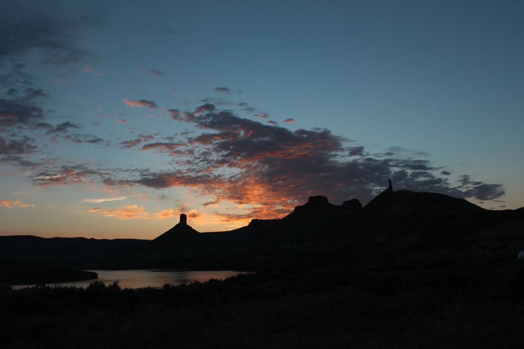
Yesterday:

Today:

Any questions?

So, we packed up for the long day on the road. Not! Colter Bay to Grant Village in Yellowstone is only an hour drive. And that's just because the speed limit is between 25 and 45 the whole route. If both places were on the Washington Beltway they'd be just 5 exits apart.

The south entrance to Yellowstone was clear. We breezed in at about noon. The route to Grant Village was narrow by modern road standards. Especially since every other vehicle in each direction was a full size bus, a giant motorhome or some jackass in a Tundra pulling an Airstream that's 8 ½ feet wide. Stay on your side of the line, Jackass! (that's what they call me in Yellowstone. I think it's my “Indian name” sort of like “Dances with wolves”). So “Stands with a fist” and I drove north and quickly realized that the road was climbing but the terrain to our right was dropping. I think its safe to call what we had there a sheer drop off of many hundreds of feet. And guess where the Federal government decided to save our taxpayer dollars... right... guardrails! I can hear the chatter at Department of the Interior HQ in DC now... “Guardrails! What a waste of money” and “Darwin would have approved of this decision to divert the guardrail fund to the President's new helicopter landing pad” (OK... they probably didn't say that... but there are no guardrails). So we drove along heading north and I insisted on pointing out every beautiful view while Mrs. C' responded to each one with “Keep your frickin' eyes on the road” (which, if I could have chosen my Indian name I certainly wold have chosen over that “.... Jackass” moniker).

We made it to Grant and checked in to our campsite which is on the very end of the campground within 200' of Yellowstone Lake. In fact, I can see the lake through the pines as I type this at 8:00 local time on Friday evening. After getting the trailer unkooked, hitch removed, spare gear out of the truck (we're going to be parked here for 4 nights) we made some lunch and looked at each other. Conclusion: Time to explore the crown jewel in America's national park system. We locked the dogs in the trailer (it was in the mid 70s and the windows were all open. They were happy to be in the silver cocoon. Trust me, they've see enough windshield time now with about 3,300 miles under out belts in the last two weeks).

We drove with the intent of heading deep into the park. On one occasion, the road was blocked with people parked on the shoulder on both sides, people pulling “U” turns in the middle of a blind curve and generally carrying on in a way that is generally associated with heavy drug and alcohol use. “What could it be?” I asked Mrs. C'. Well, as we crept through the logjam of Chevys, Winnebagos and Mercedes, we saw what it was. An elk. Unlike Jackson, Wyoming, here they seem to not turn elk body parts into public structures and so elk are visible. This particular elk was grazing near the road. He was pointed north, the road was too his south (get out a compass and map if you need to orient the scene so you know which end of the elk was presented to the gathered onlookers. Standing 20' behind this magnificent beast (which appeared to be about the size of our Airstream) was a man dressed head to toe in gear I bet he purchased at Orvis for an African safari that got canceled earlier this year. In his had was a camera with a lens more suited to taking pictures of Mars than massive wildlife close up. He was taking a picture. I like to take pictures. I particularly like sharing them with people to give a sense of wonderful places. I try to be thoughtful about my pictures. Why this man abandoned his car on a busy road to take a picture of that end of an Elk I can not explain. I hope it is a beautiful picture and he has it printed in 11” x 17” and framed to hang in his living room with a carefully chosen title. May I suggest “Self Portrait”.

Anyway... we kept driving... and driving. We crossed the Continental Divide... twice (I'm so confused about the Continental Divide right now that I can't tell you if a spit ball sent to the ground here would wind up in the Atlantic, Pacific or Indian ocean. It seems really important to them to remind us since there is a road sign every time we cross the darn thing. After about an hour we came to a somewhat developed area. I pulled out the map of Yellowstone to see how much ground we had managed to cross. We covered about 10% of the width of the park. I don't have internet, but I'm thinking that Yellowstone is about the size of New England... including Maine. Given that this is the first true weekend of summer and Yellowstone is drawing Americans like my neck draws Yellowstone mosquitoes (more on that below if I don't loose my train of thought) we are going to have to be very thoughtful about how far we try to go and what we prioritize to see. Suffice it to say that 4 days here won't be enough to “see” Yellowstone. I think we are more likely to sample it.

Well, that developed area we came to was jammed with people. They were running, walking, rolling in every contrivance from wagons to strollers to wheelchairs and all heading in the same direction. Since we we members of a species generally known to be herd animals, we joined them. I can hardly describe what happened next. Thousands of people sat on benches circling a pad of poorly formed cement and staring at any timepiece they had (watch, cell phone, portable sundial, etc.) suddenly the earth erupted with a plume of what appeared to be steam. The stuff shot 200' in the air. Here, here's a picture:


That went on for a minute or two and everyone got up and left. I've never heard of such a thing. I'm surprised they don't tell the world about this. It's one of a kind.

So we headed back to Grant Village, the trailer and the dogs. They were happy to see us, happy to eat and happy to walk since the ground here is a combination of scents including the 1,000,000 dogs that have preceded them and a few dozen bear markings (hey... we're in the woods... what do you think bears do here?). Mrs. C' and I ate in the trailer (we are well provisioned right now).

After dinner I went out for a short walk around this part of Yellowstone Lake. Short turned out to be an hour and a half since what looked on the map to be a ½ mile walk to the Lakefront Grill (I heard they serve a first rate Snickers ice cream bar) was more like 2 miles. They didn't have ice cream and I had to walk 2 miles back. But I did get some shots along the way. Check these out. All within 2 miles of our campsite and none of them even rate a mention in the average Yellowstone guide book.


I came upon a small pavilion. It looked like this from the approach on the path:
Unassuming.... right? I entered. It was laid out like an open air chapel with semi circular benches for about 40 people and a stone altar in front. I sat in the fist pew (that was a new feeling) and took this:


Today's funniest shot. Probably the most decrepit camping rig we've seen in 3,300 miles. It was parked (I assume it was driven there...) and I honestly couldn't tell which of the two vehicles which were hooked together was more likely to push or pull the other...


So, we are settled in here. Reading and writing (we have no water or electric at this campsite. We have generators but have not used them yet. I'm writing on an old fashioned hand crank computer. Perfect for the rustic simplicity of Yellowstone.

After the beauty of the Grand Teton's and the horror show that is Jackson, Wyoming, my first impressions of Yellowstone are that it may be the best of both worlds. It has the amazing natural features that we saw in the Tetons and the crowd magnetism of Jackson, Given its size and the loving and thoughtful attention the Park Service has given to Yellowstone it may well have been worth a 3,000 mile drive, the expenditure of 300 gallons of dinosaur juice and countless months of planning a preparation.

Follow us the next few days and we'll let you know if that proves true.

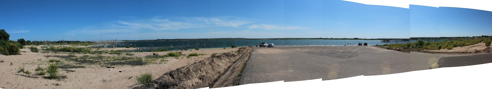
Here's the panorama of the day. A view of Yellowstone Lake from just below our campsite...there are snow capped peaks in this view... 1/3 of the way in from the right.


SC

P.S.: The mosquitoes... they are the size of normal mosquitoes here but given the long winter (many roads here are only open from mid-May to late September... the mosquito season is probably equally short) they have a lot of ground to make up. I have not see so many mosquitoes on a person's arm as I saw on mine today except in a Deep Woods OFF! commercial (the “before” shot). Like piranhas, it isn't the bite of a single individual that should worry a person. It's the fact that they travel in packs of thousands.


Thursday, June 25, 2015

A Jackson, Wyoming survival guide

'evening Campers!

So last night I promised to get some pics posted. And I did! I hope you found them on either blogger or Flickr.

This place is amazingly photogenic. It has the large scale grandeur that I do not expect to find anywhere else... even Yellowstone (which we expect to have more variety, way more accessible wildlife and genuinely unique features... but not on the scale of the Tetons.) Both of the photos I posted of the Tetons were panoramas... one from yesterday early evening and one from sunrise this morning. I think they speak for themselves.

Yesterday I ragged on Jackson, Wyoming. As we laid out our plan for the next few days over coffee this morning we hit a realization. We needed to resupply before heading into the Yellowstone wilderness tomorrow. We also needed 4G cellular service which was not happening here in the Park. We looked at our options and concluded we had only one choice... Jackson. So we suited up with hazmat gear, put clothespins on our noses and headed into the old west... sort of.

Here are some of the things we found:

The stage coach has just arrived. Turns out this one was 150 years late and brought the news that President Lincoln has been shot!


Actually I think this was a Wells Fargo Bank billboard, or maybe a tour of the town offered to tourists for $25/head... I'm not sure. I am sure that it disrupted the flow of traffic. The scene behind that is typical of modern Jackson. We walked along that row of shops as we headed back to the truck after shopping. This is the way the west should have been. Featured in the window of the “Alaska Fur Gallery” shown in that pic was a fur bra and panty set. Perhaps wolf fur... they wouldn't let me touch it to find out. I'm thinking it must be what Annie Oakley wore to keep from shivering and spoiling her shot in the cold Wyoming winters. Nice of the folks at Alaska Fur to keep that traditional apparel choice alive and on display for modern Americans!

There is no shortage of boots, hats and tee shirts in Jackson. You can feel the authenticity. Here's one that caught my eye and immediately thereafter the lens of my camera:


The one under it isn't too bad, either. Dick Cheney is from here in Wyoming. Since the town is full of bus loads of Asian tourists, I'm wondering how he explained Jackson in his diplomatic meetings with people from other countries who had visited his state and this town and had questions about the meaning of it all in America culture. How does anyone explain the inexplicable?

Finally, here is a picture of one of the 4 elk antler arches I told you about last night. See if you agree that any elk within 50 miles of here is probably ticked off about this. No wonder we haven't seen one yet!


We tanked up on supplies for the next few days and got out of Jackson. I'm not saying I'll never set foot in Jackson again. I am saying I'll have lowered my expectations before I return.

So, tomorrow it's off to Yellowstone. A short drive by our standards... 50 miles about from campsite to campsite.

Based on cell service and WiFi at the campgrounds, you may hear from us... you may not. If I'm not posting blog entries and pics just know its because we can't get a sufficient connection. I did buy a cell phone signal extender (a $350 electronic device that amplifies both incoming and outgoing cell signals to make connection possible in fringe signal areas) at Radio Shack in Jackson today (there... you see... I do appreciate the businesses of Jackson... of course they were a mile from the antler arches, stage coaches and tee shirt shops). Unfortunately, after the one hour drive to the campsite and 30 minutes on the phone with Verizon getting the device “registered” when I opened the box to install it in the trailer there was a critical part missing. I now know where the expression “not a happy camper” originated. Hopefully they will get the missing part to me by courier in the morning or by FedEx in a day or two in Yellowstone. I'm hoping it will help.

So, as I was saying... if you don't hear from us, let the anticipation build knowing we are taking pics and jotting notes about the social condition of America and Americans today and will share all of that with you as soon as possible.If you want to look up Yellowstone info and place us on a map for the next four days, we'll be at Grant Village. Those campsites have no water, no electricity (and I'm betting, no cell phone service!) so we'll be totally reliant on our aluminum shelled enclosure on wheels and two Honda 2000 watt generators to protect us from the wild... just like the pioneers! I think I'll stop calling us "campers" and switch to "re-enactors". I wonder if they kept the chocolate for their 'smores in their propane powered refrigerator/freezer like we do? I'll have to look that up if I ever get reliable internet again...

Later!

SC

Special Photo Edition!

While Mrs C' is shopping in Steamboat, I'm catching up on blogging thanks to the available Verizon service here in Steamboat Springs.

Let's go back a couple of days... Sunday... between Hays, Kansas and Orchard, Colorado:

Here's the route we've taken including today's trek into Wyoming:

Sunday Monday and Tuesday Route

So, what did we see?

Plains...

If societies are defined by their biggest buildings (think cathedrals of Europe in the Renaissance, skyscrapers in New York) then Western Kansas and Eastern Colorado are defined by their grain elevators. We saw some as big as cathedrals. Here's an example from a small Colorado town:
 Remember all those wind turbines in Kansas? Here's what they look like en route to their home in the plains. This shot is one blade and one tower section. We saw many, many trucks like this.
Jackson lake itself was a pond on the plains... if I have more time and bandwidth I;ll post pics later.

The trip to Stagecoach was amazing. Here are typical shots one sees on the way up into the Rockies and en route to Steamboat Springs


Since this is a catch up post, let me share the best of the past few days. We are still short on internet (we had to drive to Jackson to get reliable, secure internet using Verizon Wireless... limited but effective).

On Monday night we were at Stagecoach State Park south of Steamboat Springs. Here's the panorama of the sight taken literally from under the open awning of the trailer:
In the morning, Mrs. C' picked local wildflowers and made this arrangement:


Then we went to the place I described as one of the five most beautiful places I've ever been. Firehole Canyon, WY. This was the panorama in the evening near sunset again, taken right from the trailer:

and the sunrise the next morning...
After that, it was on to Grand Teton National park. Given the geography, I believe Teton is a morning photographer's place, but I could help myself last night. Here's a panorama:
Like I said... its for the early riser... which I am... so here's the best shot I've got of the Tetons so far:
That's it for now. More as scenery and internet connection allow.

SC

Wednesday, June 24, 2015

From the shores of Jackson Lake, Grand Teton National Park, Wyoming

Calling all Campers!

It's been days since I've had an internet connection at night. Now I have a barely passable one at the campsite and there is guest WiFi in the area where the shops and restaurants are about ½ mile from here. That should let me get caught up on both Blogger and Flickr with pics. Look for a special photo edition of the blog tomorrow (Thursday). When you see that the photos will be on Flickr soon.

So... where are we? The geographic answer is at Colter Bay RV park in Grand Teton National Park. Now, before you get all high and mighty with me and call me on my hypocrisy after the slams I've made about KOA's, let me say that the Colter Bay RV Park is not a KOA. This is a park set up on Federal land within the Grand Teton National Park and run by a Federal concessionaire (contractor).

We got here today by waking in one of the most beautiful places I've ever been. Then after a leisurely morning routine heading north on state highways and US routes for about 4 ½ hours.

That route took us from what is basically high desert at Firehole Canyon in Southwest Wyoming, up through high plains. As we headed north we began to see snow capped mountains. First to our right (east) which were the Wind River Range then to the left (west) which were the Wyoming Range along the Wyoming/Utah then Wyoming/Idaho border. The two ranges got closer and eventually we hit a ridge at 8,000 feet. As we crested the ridge, everything changed. We went from plains with sage and other scrubby plants to a forest of tall pine trees. We descended in that environment and streams then rivers appeared next to and then crossed the roadway. The largest of these was the Snake River. Soon mountains literally loomed above us. Rock faces (none too secure looking I'm sad to say) towered above the truck and road by 1,000 to 1,500 feet at times. At one point I said to Mrs. C' “All I'm asking for is that the rock overhang up there (pointing 500' above us perhaps) stays where it is for another 90 seconds while we pass underneath”. Nature is beautiful at rest. Stunningly beautiful. In this case with a constant, silent reminder of her power.

The steep descent gave way to the valley floor. Sadly, at the north end of that valley sits Jackson, Wyoming. Holy crap. If you took the worst of Key West, Disney World and Ron Jon's Surf Shop in Cocoa Beach and put them in a blender with some “good ole' genuine fake westernizing pixie dust” and sprinkled them on the plains of Wyoming you'd have Jackson... provided you sprinkled it with some genuine Bison and Elk dung for that simulated aged authenticity reminiscent of the old west, Pardner! Even the K-Mart had a fake wood sign on the main street. It was icky. If we decide we need a tee shirt that says “I'm the luckiest kid in the world because someone I know visited the real JACKSON HOLE WYOMING and brought me this tee shirt” I guess we'll have to go back. Otherwise we will stay in the Grand Teton region here 20 miles north of Jackson (I'm pretty sure I can't smell Jackson anymore from this distance). Speaking of Jackson Hole, Mrs. C' and I were confused about why some references are to Jackson and others to Jackson Hole. She looked it up (back when the internet was a part of our daily lives...) and learned that the fake town is “Jackson” while the valley it sits in is known as “Jackson Hole”. I know that you know where I'm headed, but let me say it anyway since it's my blog and my joke.. as far as I could tell the whole thing is a hole. Ta Da!

As for wildlife, we are just starting to spot some interesting types. There were plenty of pronghorn along the route today. We were watching and watching for Bison and finally spotted a herd between Jackson and here. They were distant but unmistakable. Mrs. C' took a picture from the fast moving Tundra with a dog on her lap excited by being awakened by the sudden opening of the window. When we looked at the pic we agreed that people who were not there to have the memory restored by the photo might ask “how close did you have to get to those ants to get this picture”. Let's hold off on the bison photos. We also crossed through the National Elk Preserve just north of Jackson. Guess what... no visible elk. Why, you ask? Maybe it's because the center of Jackson is a nice open park and that park has a beautiful entrance arch 15' tall and 15' wide at each corner made of... can you see this coming?.... ELK HORNS! I'm serious. They must have used the horns of 100,000 elk to make these arches. They're huge! If I was an elk I wouldn't get within 50 mile of Jackson for fear they'd use my pelvis as a toilet seat or my right front hoof for an ash tray and sell it in a fake western dry goods store to Japanese tourists. Give me a break. Although, being Jackson (where even the cheap metal buildings have fake 1870's western facades!) the antler arches could have been made from resin cast elk antler mockups... they give the same authentic feel as a real antler but at a fraction of the cost and the tourists can't tell the difference.

Oh yes... wildlife... so we were warned about bears here in the campground. They appear often and the rules are strict about cooking, garbage, food storage, etc. We are spic and span and ready for the night.

So let's talk local geography... the campsite and the entire campground for that matter are on the east side of Jackson Lake. I'm not sure how big Jackson Lake is. My impression is 30-40 miles north to south and 2-5 miles east to west. However big it is, many people have gone to the trouble to move very large boats here. There are 50 footers in the marina nearby. I'm thinking “What are boats that we see in Florida and people use to go to the Keys, the Bahamas and beyond doing on Jackson Lake? Then it hit me. There are enough people with enough money to burn who would send their boat (or just buy another one that's here already... why not, two boats is better than one!) from California (where there is no water anyway) to Wyoming, 7,000 feet up and nearly 1,000 miles over so they can sail past the Tetons. What a country! At least it makes jobs for truckers, people who drive cars that say “wide load behind”, crane operators, marina tenders and others.

On the west side of Jackson Lake is what all the fuss is about... the Tetons themselves. These are rough, rocky peaks that are snow capped... in fact, glacier covered in spots... that resemble the most impressive peaks in the alps. If you can't wait until I have an internet connection to show you the real pics, go to your pantry and rummage around until you find a package of Swiss Miss. Take a look at that and you'll see something like the Tetons. Ok, that's the Matterhorn (as I recall... I can't confirm that without the internet an as you know, I don't have that... much) and there are multiple peaks to the Tetons but Swiss Miss will give you a general idea of what you're missing if you have not been here to Grand Teton park.

As we drove north from Jackson with still 20 mile to our turn off the Tetons loomed over us to the left. I could see them fading behind us with still 10 miles to go. I said to myself “I think this campground isn't what I thought it would be... the Tetons will be well off to the south, not right across the lake as I expected”. Turns out, I was wrong... again... a feeling I should be quite familiar with by now according to my wife. When the Feds (or most states for that matter) build a park, especially a National Park, they choose the best land with the best views for themselves and the people they serve (that would be us... the camping US Citizen in this case). Bravo National Park Service! This site is spectacular. The peaks are to the south, but from here the tallest of them line up in a row. It makes photographing them very nice since they sit in a single frame. Had the park been placed to the South, more directly across Jackson Lake from the peaks themselves they would cover a span from well south to well north of the viewer. You'll see when I finally post the pics. Anyway, the campsites are all in the woods about ¼ mile from the lake. That's actually smart since there are trees, shade and a certain egalitarianism since no section of the camp has a better view than any other. Actually, we hate that since we tend to plan well in advance, have the flexibility as retired folk to come at the best times, are blessed with pensions that allow us to say “sure... I'll pay that” and generally land those coveted spots where we can park the Airstrem and look smug as people from lesser spots walk by. We'll have to be less smug this time (although it looks like we have the only Airstream in the park right now and there are 120 spots...). And you know what? In a National Park for the people of the US of A this is the way it should be. Everyone has a similar space to enjoy this amazing place and we can all do so as US Citizens together. The lake front and best views are unobstructed by Airstreams or Prevost motor homes the size of Greyhound buses and open to all.

More tomorrow gang... and pictures I promise.

SC

PS. I'm going to press my luck with one Grand Teton pic... 
 
At Grand Teton National Park, COlter Bay RV Campground Wed night. Baaaaarrrrreeeellllyyyy connected through Verizon. Posting last night's blog before writing tonights. Amazing pics to follow from past many days when I get to the guest WiFi later tonight or tomorrow (at the cafeteria in the center of Colter Bay, I think there is a Snickers Ice Cream bar there with my name on it. Man can not live by 'smores alone!)

(Written Tuesday night from Firehole Canyon Campground, WY)

Howdy Campers!

What a day, what a day, what a day!

We started out at Stagecoach State Park just south of Steamboat Springs. It was cold at dawn... at least for us Floridians. We didn't have a thermometer handy, but I'd say 10 below (that's around 50 for you people who live in Northern climes). So I surprised Mrs. C' by making scratch scones (almond/dried cherry... our house specialty) using the convection feature of the oven in the Airstream. This is a Sharp combo microwave/convection (i.e.: regular heat) oven. It is the perfect cooking appliance for this rig except for one thing. It's user interface was designed by dyslexic cryptographers. Native Korean speakers at that. Even with the manual open to page 137 on my iPad it took me four tries from start to tell it “heat to 375 degrees and get ready to cook some scones!”. At one point Mrs. C' said “how many buttons do you have to press to start that thing? I said “shut up... can't you see I'm making you scones???”. That sort of spoiled the moment I guess, but to her credit she shook it off. We ate fresh scones with our coffee while watching the sun rise over Stagecoach Lake.

After a bit we went into Steamboat for a bit of shopping and top off the gas tank while we had no trailer and no dogs. Mrs. C' found a shop so nice that we barely got back to the campground in time. The next happy camper with our site reserved was checking in at the gate as we drove in. I hitched up while Mrs. C' made some fresh sandwiches and grabbed cold drinks from the fridge and we were off for Wyoming.

Remember that thought I shared that we were headed for cooler temps as we neared Yellowstone? Apparently we are not heading there fast enough. It was over 90 most of the day including when we arrived here at Firehole. Yes, I said Firehole. Yes, I should have thought about how a campground I picked for late June may have acquired the name “Firehole”. I have an excuse. The US Government (who owns and operates this place) fooled me. The picture they showed of this campsite on their reservations web site had snow on the ground. I figured we'd need gloves. So much for my application for a MacArthur “genius grant”.

Anyway... Firehole Canyon Campground. Let me say that I have had the privilege (thanks largely to my employer of 34 years) to see much of the world. In my travels I have see beautiful and spectacular places (and the other end of the spectrum too... I think that's nature's way of making sure we know the beautiful and amazing when we see it). Firehole Canyon is without a doubt in the top 5 most beautiful places I have ever laid eyes on. It takes a bit of work to get here - it's in the Southwest corner of Wyoming – but its worth it. About 40 minutes up the road we got off I-80 to head south to Firehole. Just before exiting we saw a KOA (remember KOA? We almost stayed in one in Limon, CO. Fortunately my gag reflex kicked when we saw the campground just before we had to exit. It saved us. Anyhow, KOA's are trailer parks where the residents rent by the night. That gives them all the charm of trailer parks you may have seen except that they lack the unmistakable trailer park pride of ownership.) So the KOA north of here was full... packed in like sardines. Here at Firehole? Maybe 15 groups. Unbelievable! I think I understand how America operates. And these same people who are side-by-each in the KOA on I-80 when they could be in one of the most beautiful places on earth with the exertion of 40 minutes of energy and initiative blame Congress for the way America works! Oh well... we're here.

Speaking of America, in one stretch today we went over an hour without passing a gas station, In fact we probably went longer and didn't see a town and rarely a house (the occasional ranch, yes. House, no.) Northwest Colorado and Southwest Wyoming are empty of everything except bluffs, oil wells, pronghorn antelope and sagebrush (or some other tumbleweed-looking thing... I don't know and without any internet I can't find out. Maybe I'll research that later.) At one point in that hour, Mrs. C' commented “My heavens. We are in the middle of a vast and amazing nowhere” (those of you who know her can substitute any adjectives you choose into that sentence to place it in her own voice). I readily agreed with her observation. However, 10, 15, 20 minutes later as we crossed ridge, hill and bluff each crossing revealed at least as much nowhere ahead of us as we had passed at the time of the observation. Do you know what? Sometimes when you think you are in the middle of nowhere you are actually still penetrating the outer fringes of nowhere. There may be 10x the nowhere in front of you that is behind you and you have no way of knowing. With perseverance and (fortunately) a pretty full tank of gas to begin with, we managed to cross the nowhere that is the Colorado/Wyoming frontier and reach Firehole.

As I write this it is Tuesday evening. About 9:30 local. The sun has set. There will be absolutely amazing pictures when we reach civilization (hopefully tomorrow evening from Jackson Lake directly across from the Grand Tetons). When you see the pics remember this (I didn't know it when I saw the Government-pics from here). The stone tower formations in the pics are about 2 mile away and probably 2,000 feet higher than the campsite. This place photographs well, but the reality is far better.

OK... its a wrap for tonight.

Later, campers!

SC

Tuesday, June 23, 2015

Chillin' in Steamboat and Stagecoach State Park

Evenin' Campers!
(Note: Written Monday night at Stagecoach State Park... posed Tuesday morning from Steamboat Springs where internet exists)

Well, it's now two nights without an internet connection. Last night at Jackson Lake in the plains and tonight at Stagecoach State Park outside of Steamboat Springs high in the mountains.

What a drive today!

We started at 4,800 feet or so in Orchard, Colorado about 50 miles Northeast of Denver. We took I-76 then I-70 to Denver then stayed on I-70 for 50 miles or so to Dillon, Colorado. At our maximum, we were 11,013 feet which is the elevation of the Eisenhower Tunnel on I-70. Truck, trailer, Mrs. C' and the two dogs all took the hills in stride.

What views! I can't wait to post the pics but we are two nights now without internet at the campground. We connect at various points of the day... but when I'm driving. Sooner or later I'll add pics back to my posts.

So we got to the campground and it is rustic and Rocky Mountain beautiful. I'll save you the 1,000 words if you'll wait for my pics.

When we arrived it was 82 but dry and breezy enough to be comfortable if you were outside. In the trailer the sun shone full force on one side. We turned on the fans, put ice in the dog bowl, unhitched the truck, threw the dogs in the trailer and headed for town! Did I say I put ice in the dog bowl? Oh yea.. oh yea... I did say that.

So we headed to town for important government-related business... to stop at the the post office. Steamboat Springs is a ski town in winter (the ski area looms over the little town.) and a tourist destination for mountain watchers and mountain bikers and strange people of many sorts. Hey, did I mention yesterday that they sell dope here... wait a minute... I think I was told they call it weed now. It's important to know that to fit in here in Colorado. So in Steamboat Springs there is this main street. They call it Main St here. I'm good with that. Lot's of outdoorsy stuff. There's also a rodeo venue right in the town of Steamboat Springs.

Slightly off the main shopping areas are the usual professional, commercial, etc. businesses. A tourist map even showed where they sell the weed. Crazy, huh? Like tourists are interested in visiting high security retail operations when they visit Steamboat Springs. We drove by one and there wasn't even a line to get in.

Seeing that the shops on Main St. sell stuff we don't need at prices we won't pay, we headed to the grocery store for some provisions. Then we headed back to the park, the Airstream and the dogs who were, by the way, just fine and the trailer was very livable especially if you had a bowl of ice water to slurp from if you needed to.

We whipped up some dinner... made a fire and sat around it humming John Denver tunes as the sun settled then we watched the sky with all its colors slowly fade and the stars came out. Colors, stars, the slow cooling of the day into chilly evening, birds flying over the lake to their roosts for the night, very nice, very peaceful. We had a couple of 'smores thanks to the coals of the fire and headed inside to get away from the bugs which were coming out for the night.

So, that's our day in Steamboat Springs. It's not a college town, but we noticed the youth, vigor and health of the people here. Upon reflection that may be less a statement of the population of Steamboat Springs and more a statement of the people we are used to seeing in Vero beach Florida. Either way, Steamboat has that kind of youthful energy and I can see how it can take you back to one's college days just with one visit.

Sunday's news available Tuesday in Colorado!

Howdy, Camp-folk!
(written Sunday... posted Monday... make that Tuesday... went two nights w/o internet!)

Well, you can call us the “High Plains Drifters”. We spent most of the day on the high plains.

We left Cedar Bluff with the expectation of a day that would be hotter than Bill Clinton's unpublished “My Greatest Days in the Oval Office”. You may recall we were wrestling with where to land tonight since the campground we had booked was in the hottest part of Colorado and (according the the reference material) didn't have sufficient electricity to run the AC. So I booked an alternate in a Kommercial Kampground (that would be Kampgrounds of America in Limon, CO). Upon further research and consideration we realized that the KOA in Limon was for klowns. It was a trailer park only worse... they rented the land by the hour... the trailer people there hadn't even made the simplest of commitment by signing a lease on their corner of paradise. If I had wanted to live in a trailer park in Colorado I would have dropped out of high school and followed Horace Greely's advice. So I called the originally planned State Park and asked if they had any spots that might have more modern electricity. In fact, they said all of their campsites do! Well, that's not what their reservation system says but the day was solved and we are in Jackson Lake State Park as planned near Greely, CO.

As forecast, the trip was hot, hot, hot. If you ever long to actually see the “amber waves of grain” this is the drive for you! Stuff is growing everywhere and there is hardly a town or person to be seen tending it. I came away with a sense that the corn and wheat may grow themselves... at least at this stage somewhere between planting and harvesting.

As those of you who read the news may know, Colorado has liberalized its stand on recreational marijuana. It's legal here. As we were approaching and entering Colorado, Mrs. C' was doing on some jewelry making to pass the time. She hit on a business idea! Soon the novelty of a simple “dispensary” (I still think they should be called “head shops” like in the 60's and 70's) will wear off. People will want to have one stop shopping for their mood altering and hobby needs. In Arkansas we saw a liquor store that was attached to a gun shop. I'm thinking the State required a wall between them inside... but from the outside they looked like one business. It probably wasn't the most encouraging or inspirational landmark to American commerce that we've see on the trip thus far. Anyway back to Colorado and jewelry making... how about a chain of dispensaries that also sell jewelry making supplies?! We'll call it “Weeds and Beads”. What do you think? For a motto, how about “Wow, did I make that?” We may be looking for investment partners.

The trip across the last 160 miles of Kansas got flatter and flatter and higher and higher. When we reached Kanorado, Kansas we were at about 4,000 feet. There were some minor ups and downs but almost no appreciable hills that got us from 2,400 to 4,000 feet along I-70. Just a steady climb averaging about 10 feet per mile. No ear popping whatsoever.

In the Western Kansas/Eastern Colorado section of I-70 almost every exit and entrance from the highway has barricades in place. There are signs with flashing lights that tell drives when and where to exit if the road is closed. If the road is closed???? What the heck? Things get so rough here so often in the winter that the State DOT's of both states spent beaucoup dollars so the highway could be closed anywhere at any time. We Floridians came away with the feeling that we came here in the right season. Maybe the heat isn't that bad after all!

Eastern Colorado is truly high plains. We were above 4,000 feet continuously and reached the mile high mark near Arriba. We topped out at about 5,600 feet before turning North to get to Jackson Lake.

Saturday, June 20, 2015

Hangin' in Hays

Hey, Campers!

Silver Cliche' here (why Silver Cliche', you ask? We started with that explanation I think... but just in case... we are two retired folks from Florida traveling the US with a small dog pack in an Airstream. The Airstream is the silver part. The rest is an American cliche')

So, we didn't move the trailer today. It was a day off... a stay put respite. I you have a burning desire to see where we are at this moment, look at last night's blog. See the pic of the truck and trailer? They are still there.

What we did accomplish today was a trip into Hays, Kansas. I hadn't heard of it either. However, according to one source we read, Hays is the economic center of Western Kansas. Let me explain the implication of that statement. It is 160 miles west to Kanorado, Kansas on the Colorado state line (Kanorado... get it? Cute huh? Yea... me neither.) It is about the same to the south to Oklahoma and probably 100 miles north to Nebraska. Hays is a city of  21,000 people and the area of Kansas to the West, North and South of Hays is roughly 42,000 square miles. That is slightly smaller than the entire state of Pennsylvania. The same as Virginia or Tennessee and 3 1/2 times the size of Maryland. That's just the western third of Kansas. Now, if Hays (pop 21,000) is the economic hub of that wheel, there isn't a whole lot of economy spinning out there!

If you've heard anyone talk recently about how the earth is overcrowded and there's nowhere left to put people and stuff, send them to Kansas... trust me, there's plenty of room!

Anyhow, back to Hays... despite my disbelief about the economic clout of little Hays, the town was just what one might expect from very small town, rural America. Two grocery stores, lots of churches, plenty of old buildings (many empty) and some restaurants. We saw a surprising number of very large, very well cared for homes. Maybe that argument about the economic center of things has some merit after all.

While we are talking history, I mentioned Kevin Costner and Dances with Wolves last night. I was inspired by the geography here and it reminded me of the movie. It turns out that in the movie, Costner's character was sent to the frontier to... wait for it... Fort Hays! Well, Old Fort Hays is an attraction right there in Hays. I did a bit of research to learn that the esteemed Mr, Costner decided that Hays didn't look enough like Hays to suit him so he pretended to be in Hays when he shot the scenes of  Fort Hays near Rapid City South Dakota. Hollywood... geez.

We turned to Trip Advisor to ask "What's the best restaurant in Hays?" and learned the answer, far and away, by popular acclaim was Gella's... so we went. This area was settled by Volga Germans. These people are ethnic Germans who lived along the Volga River in Russia. The Russians encouraged them to move there in the 1700's and later the Volga German's decided to leave. First in the 1800's (that's the wave that hit Kansas) and in droves as WW II began (I can't imagine why ethnic Germans in Russia felt unwelcome... I'll have to go and reread my 20th century Europen history.... oh, that's right.... people who looked like, talked like and carried the same names as the Volge Germans were maurading across Europe. I'm guessing the Volga-folk felt the heat from their neighbors). That has nothing to do with lunch at Gella's in Hays except that on the menu was Bierock... specifically identified as "smothered Bierock". Mrs. C' pondered other menu options while I pulled out the Android, dialed up Google and asked the logical question: What's a Bierock? Answer: A pastry crust filled with meat and cabbage and baked. It was a Volga German traditional food. I thought of it as a Volga German calzone. I'm guessing you've never had a Bierock. As of today, that's something that makes you and me different. Here's a shot of my lunch:

(the onion rings were an extra... well worth it!) Now, the Bierock was indeed "smothered" but to my palate it was Velveeta. Call me a skeptic, but I'm not thinking that part came with the Germans from Russia. The filling was more believably authentic. Beef, cabbage, onions, seasoned with sage. An unusual find. I can hear you asking: "SC, will the call of Bierock bring you back to Hays on another journey?" Answer: No. Nice place, Hays. Time to move on and escape the pull of the Bierock.

We will hit the road in the morning for Colorado. Just in time too since it was 99 degrees here today. We had a hard time keeping the trailer cool even with the AC on all day. Something about sitting in direct sun that overwhelmed man and machine. Our plan was to head to Jackson Lake State Park northeast of Denver. However the heat that hit here today is going to be there tomorrow and their campsites have anemic electric service an won't run the AC. We could hook up the generators, but as an option we have a space at a commercial campground (ugh... parking lot for RV's with people living in them... we just don't do that except in an emergency) just off I-70 east of Denver. Then on to Steamboat Springs the day after that, then into Wyoming. We expect to see overnight lows in the 40s within two days.

For each of the days at this part of our trip we double our altitude. Yesterday we went from 1200 to 2400 feet, Tomorrow to 4800 and Monday over 8,000 in the Rockies. I might even feed the Tundra some extra oats for that service!

One last shot from Kansas for you. Today's panorama is from the shore of the Cedar Bluff Reservoir, That's the water around which this state park is formed, yesterday's pic was from the dam that forms the lake, Today's is from the damn lake itself.


I'm thinking they have room for a couple of cubic miles more water than they have right now. It seems the closer we get to California the less water there is. Maybe they can call Kevin Costner and tell him to pretend California is somewhere where there is water.

Later...

SC