Wednesday, May 19, 2021

She’s blowing’ up a gale!

Good afternoon, Campers! It’s Silver Cliche’ with you again. Today’s post is coming to you from Sunset State, Beach in Watsonville, California.

Yesterday was spectacular and a bit harried. We called the option play and decided to run from Plaskett Creek. The weather on Monday... here... let me remind you what it looks like to be cold and damp... or, more accurately, to be warm and dry but looking at others who are cold and damp...


Got it?... nobody wants that! Right? Anyway, being in one place at Big Sur kind of misses the point of the place because Big Sur isn’t actually a place... it’s a long stretch of coastline. And a varied one. Since there is only one way in and one way out, the way we decided to experience it was to drive out. Anything else would have meant seeing the same place over and over. 


Our destination is smack dab on Monterey Bay about 90 minutes north of Plaskett Creek. To complicate things, the trusty Tundra was due for its 10,000 mile service and the Toyota dealer we had chosen was about 30 minutes south of the campground. Even in the land of milk and honey somebody has to do the milking and collect the combs. So rather than dilly dallying along the route we made a steady drive up Highway 1 enjoying the spectacular sights of Big Sur. Just so you don’t miss out, I stopped to take a shot for you:
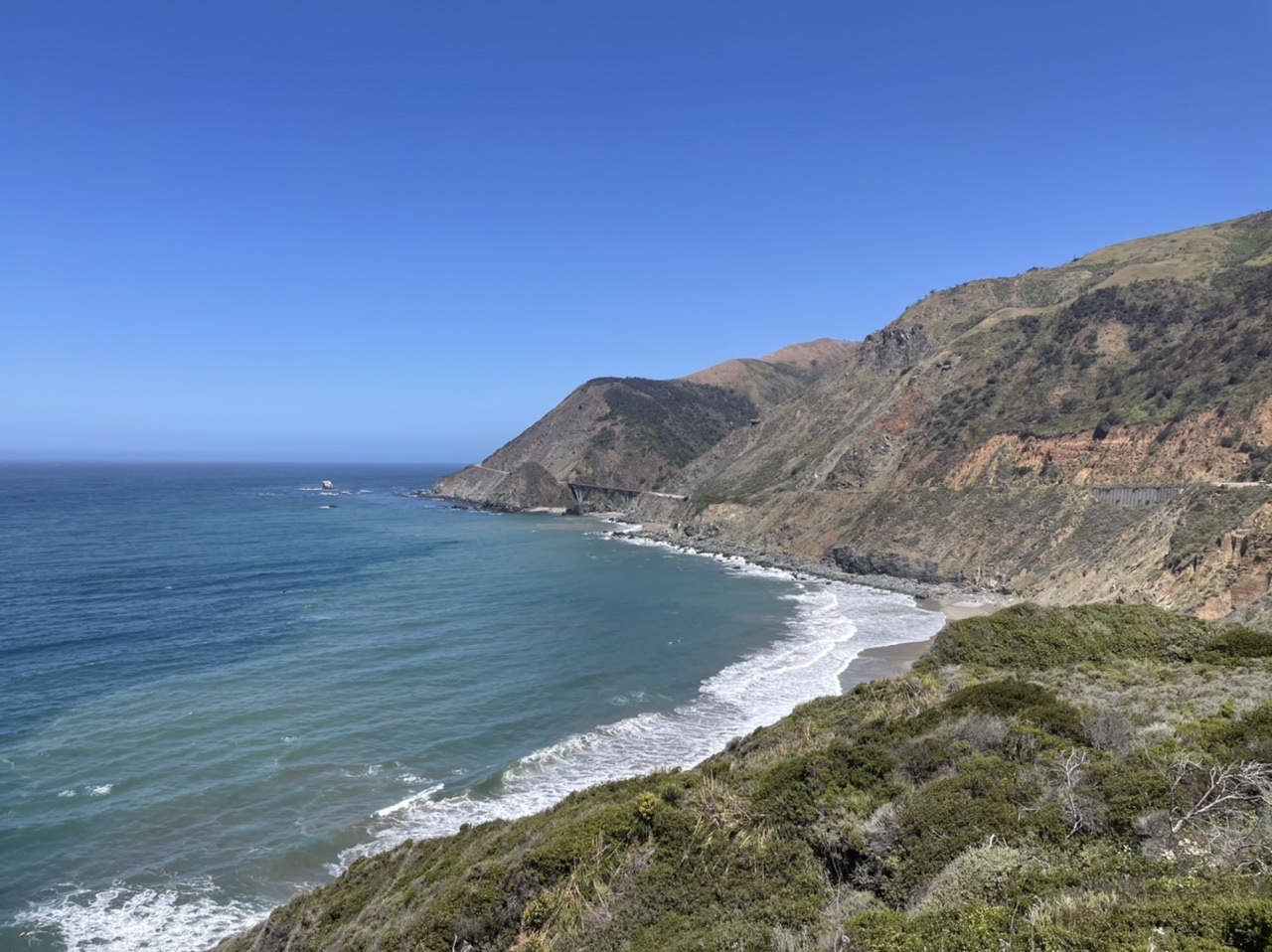

Yes, that is a retaining wall holding the road up on the right and a bridge holding the road up on the left. Thankfully, both performed perfectly minutes after I snapped that as we rolled north.


The things I didn’t appreciate about this route are numerous. First off, the landslides. I was aware that this road is damaged badly enough to require closure on occasion. In fact, the first time we planned to drive it in 1980-something it was closed. This winter it was closed and only reopened three weeks ago. I’m thinking it gets hit about every two years by a doozy that makes news. However, it appears to get hit daily to one degree or another. And weekly, monthly and yearly by events of increasing severity. The only thing more common that patches on this road are “Watch for Slides” signs. Note that they don’t bother describing what type of slides... the answer is “every type of slide”. At one point there is a short tunnel... maybe 100 yards. I realized from its construction that it wasn’t a convenient way for the engineers to avoid a switchback or hairpin turn by burrowing through the earth. This “tunnel” was actually a roof for cars and a sliding board for rocks. Evidently, the frequency of boulders falling on the roadway at that spot led the California Highway Department to construct an overpass so falling chunks could reach the sea safely without having to look both ways before crossing (which, I’m thinking they never did anyway). The second surprise for me was the varied vegetation. It’s about 50 miles from Plaskett Creek where we started to Carmel by the Sea. At times we were rolling past dried grasslands (populated by grazing cows enjoying the best view in the entire bovine world). At other times we were in redwood forest... I mean thick, huge, old growth trees on both sides of the road. The wildflowers were in bloom and added to the magnificence of the Pacific which itself was a deep shade of blue. Various types of small trees, scrubby stuff and pines in ravines came and went past the window. The niches of climate, soil and sunlight clearly have a dramatic effect on what will grow in any specific square foot of earth here. Finally, I was amazed at the variation in elevation. We were as high as 800 feet above sea level according to the altimeter on my Apple Watch. Given the twists, turns, narrow stretches and traffic (not to mention the constant watching out for “slides”), I didn’t get to consult the fine print on my watch as often as I would have liked. Maybe there were even higher spots. I might have asked Mrs. C’ to keep tabs but she was keeping watch on me and threatened to beat me to a pulp (once the truck was stopped and safely in park) if I didn’t keep my freakin’ eyes on the road. This stretch wasn’t the first time I’ve heard “Are you trying to kill me?”. As a point of fact, a plunge off an 800 foot cliff into the ocean would probably have an equally detrimental effect on all of the occupants of the vehicle... not just the front seat passenger. I used my substantial EQ to determine that Mrs. C’ would not find that logic to be comforting or persuasive at that moment, but I found it helpful so I’m sharing it with you.


By reputation, the trip we took in two segments on California Highway 1 from San Simeon to Carmel by the Sea is one of the most beautiful drives in the U.S.. For us, it delivered.


So, we reached the campground in Watsonville on Monterey Bay at about 2:00 on Tuesday afternoon. My service appointment was at 3:00 in Seaside about 35 minutes back the way we came, so I unhitched the wagon, tested all of the vital systems in the trailer (especially internet), and left my traveling companions behind. After an oil change, tire rotation and the “50 point safety inspection” (Do you think there really are 50 points inspected? Me neither.) I headed back to Watsonville passing (as I had done earlier) Salinas, Castroville and Moss Landing along the route. You can’t pass Salinas without singing the last verse of “Me and Bobby McGee” which I did. I had done my research, called ahead and stopped at the harbor at Moss Landing to pick up fresh seafood dinners for Mrs. C’ and me. I literally had to wait on the road just outside the restaurant/fish market while a forklift moved something from a commercial fishing boat to the building next to the market. I also saw my first “sea otter crossing” sign on that road, although no otter interrupted my trip.


The fresh fish and chips were a hit as was Mrs. C’s chargrilled halibut. The carrot cake wasn’t bad, either.


The last miles from Highway 1 to the campground were teaming with agriculture. Two products dominate the area within about 10 miles of where we are camping... strawberries and artichokes. We saw pickers working the strawberry fields. We also saw trucks with stacks of cardboard. I realized they were delivering those heavy cardboard trays that carry bulk strawberries to the fields that were being picked. It was possible to see the fields in various stages of growth from bare dirt to the ones with the pickers in them. I think I saw the May, June, July and August crop... maybe September, too. I’m not sure how long it takes to turn a seedling into a shortcake here. The fields reach right up to the edge of the campground. Here’s a shot I took this afternoon when I drove back from the beach:


The beach... the beach... We are just a few hundred yards from Monterey Bay. There are major dunes, probably 300-400 feet tall separating the campground from the surf. That may sound like a lost opportunity fir beachfront camping, but the wind today is 30 MPH with higher gusts. Those dunes are protecting us somewhat from the wind but certainly from wind blown sand that otherwise would be sandblasting the finish off the truck and trailer. 


Monterey Bay itself is probably 20 miles north to south with the City of Monterey forming the southern point and Santa Cruz the north. It is characterized by cold water (the Pacific here is about 50 degrees today) and a very deep ocean trench close to land. The harbor where I supported people removing creatures from those waters for the benefit of humanity included several “whale watching” businesses. None of them suggested you’d come back full. I’ll pass.


Monterey Bay courtesy of Google Maps. We are camping on the Bay just above the midpoint.


On a cold (by Florida standards... evidently, these people think it’s normal) and windy day I braved the elements to bring you these shots of Sunset State Beach and Monterey Bay.

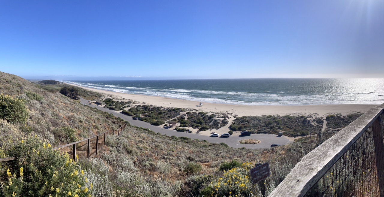

That’s the same beach twice. First from sand-level then from the overlook above the beach. I literally saw two women in bikinis at the beach and I guy with shorts an no shirt. It was 57 degrees with steady 30 MPH wind. C’mon people... focus... focus.


So, tomorrow we head east with a plan for one stop in the San Joaquin Valley then Yosemite. We are working up another option play because the forecast for Yosemite Valley is cold and rainy. By “cold” I mean “too cold for us” as in 30s at night and 40s in the day. So our “Plan B” may be to hang in the warmer valley, shorten our planned stay in the Yosemite area and only go there for Sunday afternoon and overnight before heading to Sacramento then north into Oregon next week. 


That’ll be the subject of tomorrows blog. I hope you’ll come along!


Later...

Tuesday, May 18, 2021

We come to these places so you don’t have to

Good morning, Campers! It’s Silver Cliche’ here with you from damp, dank, dark Big Sur, California. 

Mark Twain once write that the coldest winter he ever endured was a summer in San Francisco. Well, we are not quite to San Francisco (nor are we going) nor is it summer, but this morning broke ugly. A light rain and temps in the low 50s. Here at Plaskett Creek Campground, we are the king of the hill. Remember our stop at the French Quarter RV resort where we stood out like the Beverly Hillbillies in the time before Jed struck it rich? In this neighborhood we are the “after”. Most people here are tenting. Some are “car camping”. In places other than California, “car camping” is better known as “being homeless”. That isn’t actually what is happening here unless the homeless of California drive late model Lexus and Mercedes products. Well... this is California... maybe they do! These people seen to have chosen to experience nature this way. Evidently, Californians have expanded the “paleo” trend from just a diet to a complete lifestyle. I think I saw a Land Cruiser a few spots down with the California vanity plate “Cro Magnon”. These Californians... so creative!


Our shiny trailer literally sits in a spot on the upper edge of this campground and looks down on the tenters below. I would have been embarrassed to make up a metaphor like that. But since I didn’t have to make it up, I think I’ll run with it shamelessly. I feel like I’m getting in touch with my “silver privilege” here in California. I must confess that self-awareness of “silver privilege” is a feeling that brings internal conflict. It’s a bit unsettling. I comfort myself with the knowledge that neither they nor I were born to our current situation. We are both reflecting lifestyle choices we’ve made. There, that’s better. I think I’ll have another cup of hot coffee from the galley stove and take off this fleece since the furnace is working a little too well. Then I’ll open a shade and watch the tenters and car campers to see if I can pick up some pointers on starting a wood fire in a cold rain.


So, I started writing this Monday morning. It’s now Tuesday morning. Yesterday was bleak. However, the forecast was for warming from the low 50s waaayyyy up into the upper 50s and for the drizzle to stop then the sky to clear. Our plan was to be lazy and watch the homeless... I mean “car campers”... from inside our metal igloo then venture out to see Big Sur and photograph it for you. It turns out that the weatherman got the temps right, and the drizzle stopped, but a cold fog enveloped the coast all day. It never became inviting. It never dried. Like the “Cat in the Hat” we stayed in and played most of the day.


Eventually, I get itchy no matter what the weather. By later afternoon I decided to venture across CA1 to a point of land that’s clearly visible on the map. Here are some pics I took. I was struck by how beautiful this spot was and the thought of how much better it would present with some natural light.


I returned to the fortress and shared my pics with Mrs. C’. Then I found the first tick crawling on me. Uh oh! I never thought about that while I was drawn closer and closer to the bluffs overlooking the rocks and breakers. That walk had taken me through taller, thicker undergrowth and less frequently traversed trails to capture my pics. Then I found the second tick crawling on me. Fortunately, these are the bigger wood ticks and even my old eyes and failing tactile senses could id them. But the thing about finding two ticks is the nagging thought that there may have been three. This could be the place that inspired Brad Paisley to write his famous county’s love song “I’d like to check you for ticks.” Big Sur is a place that inspires romance and wonder.


We plan to leave here today. If this trip was a football game, today was designed as an “option” play. We have this spot for two more days and the weather is forecast to get slightly better but we also have a spot at an oceanside campground 90 minutes north near Watsonville. We decided to make that drive slowly, stop at spots along CA1, get the truck serviced in Monterey (yep... it’s 5,000 miles since it’s last service on April 2 and 4,601 since we left Vero Beach), explore Monterey a bit by Uber if we choose to then settle into Sunset State Beach for two nights.


I hope you’ll ride along with us.


Later...

Monday, May 17, 2021

Recent pics... part 2

Straining to get things uploaded. It’s just pics tonight. Hopefully tomorrow I can upload videos, too and they will extend the pics to give better understanding.

General Sherman... take 2!


Our first view of the Pacific taken by Mrs. C’ while we rolled north on CA1


Just pics from recent days

Kern River, Kernville, CA sunrise looking north (upstream)

Our campsite just above the river shot

A portion of California Route 155 (that carried us from Kernville to Three Rivers with life-threatening moments) as seen by Google Maps.
A beautiful barn in the middle of our CA155 ordeal

The General Sherman — World’s largest tree (he’s the topless one on the left)


Ran out of bandwidth... to be continued...


Sunday, May 16, 2021

From sea to shining sea!

Good evening, Campers! It’s Silver Cliche’ with you again. Tonight we are safely parked at the US Forest Service Plaskett Creek Campground in Big Sur, California!

This trip (remember, we call this one “the Trip to Everywhere”) was planned to allow us to finish the lower 48 in the Airstream. Here’s the count as of now:


States visited this trip: 10. New states camped this trip: 2 (NV, CA)

States camped lifetime: 34. New states to go this trip: 14 (OR, WA, ID, MT, ND, MI, VT, NH, ME, RI, MA, CT, NJ, DE)


Even though the design point for this trip was “state bagging”, there are some secondary objectives. For example, we will camp directly on all five Great Lakes. Tonight marks completion of another objective... we are within sight of the Pacific Ocean. Not bad for two old folks and a 7,000 pound aluminum bubble pulled by a 7,000 pound steel mule! In 30 days we’ve managed to see both the Atlantic and Pacific.


We barely have cell service here, but I’ll try to catch you up with some of the pics we’ve missed sharing with you the last few days. (Tried and failed! I still owe you pics and will keep trying... SC’)


Today started back at Three Rivers. Since we were on full hookups, we took advantage and caught up on our laundry. I try to avoid some of the grittier aspects of life on the road while living “close to nature” with two people and two dogs but tonight requires me to open the kimono a bit more than usual. Although the dogs have their own bed built in next to ours, they prefer,not to respect the boundary. Golden Retrievers are notorious “cover hogs” and Zachary if raising that tendency to “hall of fame” levels. Let’s just say that after 30 nights there was a clear indication of where he likes to sleep on our quilt. 

Our little washer might handle a twin, but not a queen quilt so we decided to put it in a bag until we get home and replace it for the rest of this trip with a new quilt in a duvet cover that we can wash. Target provided the goods on Friday. This morning was time to re-linen. So, being the trailer-husband that I am I volunteered to put the new quilt in the new duvet as part of remaking the bed. I probably should have volunteered to defend us from any giant squid attacks because I learned that a queen sized quilt and it’s duvet have more arms and better attack moves than a giant squid. First off, I searched all four sides of the duvet and could not find an opening. I figured this was made using some Army technology that I hadn’t read about on AirForums. Mrs. C’ offered to inspect the duvet and showed me the top-secret hidden row of buttons inside the folded over section on one edge. I’m sure I could have figured that out. She asked if I wanted her to put the quilt into the bag. I said “No, no... I’ve got it.”. I contemplated turning the darn bag inside out or maybe putting my entire torso into the bag and dragging a flashlight in to properly align the quilt. That’s when I discovered tie strings in the corners of the duvet. “Ah ha!”, I exclaimed. I’ll turn this sucker inside out and tie these bad boys to two corners of the quilt then roll the duvet over the quilt... kind of like folding the peel back onto the banana for storage! Well, actually, not exactly like re-peeling a banana since that never works. But I was sure my approach to duvet management was sure to succeed! So, I tied one corner, tied the other and inverted the bag to envelop the quilt. VOILA! That wasn’t so hard, after all. Mrs. C’ was watching this step and asked if I wanted help. “No, no... I’ve got it.”. I said. When I finished re-peeling and went to lay the quilt in its cover in the bed I realized that the length of quilt inside the bag where it should span our chins was greater than the length of the bag. To make matters worse, there wasn’t enough quilt in the bag to reach from our chins to our ankles. Uh oh! Either the quilt or the cover was going to have to shift 90 degrees. Back to square one. Untie the corners, index the quilt one quarter turn in the sack, retie. VOILA! That wasn’t so hard after all. Mrs. C’ was watching this step and asked if I wanted help. “No, no... I’ve got it.”. I said. That’s when I discovered that the corners at the end with the Soviet-era bag/button hidden seam technology had ties, too! That’s genius! I’ll use them. I had to wrestle the squid again to allow fresh air and daylight to reach the ties so I could use them as intended. Tie one. Tie two. VOILA! that wasn’t so hard after all. Now, to understand what went wrong with that operation I must describe how a wannabe engineer thinks of a quilt and it’s duvet. Imagine, it you will the duvet spread perfectly on a large, flat surface. I say “imagine” because a quilt and duvet never exist in that perfect, flat configuration in nature. In your mind, assign a capital letter to each corner of the duvet beginning at the upper left (A), the moving to the upper right (B), lower right (C) and lower left (D). Then do the same with the imaginary quilt which is mostly hidden in the bag but use lower case letters this time. a-b-c-d. The properly tied corners align like-letters using the built-in ties to join them. Aa, Bb, Cc, Dd. I did that. VOILA! that wasn’t so hard after all. When I spread the quilt out it looked like an “X” inside a square... like the example of a perfectly completed mark on a paper ballot or SAT test. Mrs. C’ was watching this step and asked if I wanted help. “No, no... I’ve got it.”. I said. Some careful diagnostic work led me to believe that my quilt was tied Aa, Bb, Cd, Dc. Hmmm... the quilt has more squid-like moves than I suspected. I untied Cd and Dc, switched corners making sure the quilt was approximately flat and not double twisted in the process (after all... I’m not an incompetent idiot when it comes to putting a quilt in a bag!) and retied. VOILA! that wasn’t so hard after all! I buttoned the sack and we were done! 


After the washing and duvet management, getting from Three Rivers to Big Sur was a 3 1/2 hour breeze! The first half was through the farm country of the San Joaquin Valley. I saw far fewer crops and far more sun-baked grassland that I could have imagined. After 30 miles of rolling tan land more reminiscent of the Mojave than of Eden, we reached Paso Robles where we reprovisioned, gassed and grabbed to vegan sandwiches from a top rated shop and two apple fritters from a donut shop across the street. I would learn later when we consumed both that I am not a vegan but I might be a fritterer.


Paso Robles was the first town we have seen in weeks that struck a “home town” chord with Mrs. C’ and me. The parts we saw were clean with an appealing mix of modern conveniences with lovingly tended traditions. For some reason, being in that part of California made me talk like Spicoli from “Fast Times at Ridgemont High”. “Du-hu-hude. Those sandwiches were gnarley.” Fortunately, Mrs. C’ was the only person who was there to hear me, she shook her head and said “Cut that out”.


We headed west with an hour to go and crossed gorgeous rolling green hills dotted with vineyards, wild flowers and grazing cattle. It’s clear that this area is undergoing a transition fueled by serious investment. We saw more Ferraris than expected and about half of the vineyards were newly established and too young to be productive. Several wineries were even still under construction. Meanwhile the cattle operations were based around weathered barns. Some major investments are shifting the future if the area around Paso Robles. 


The last 40 minutes of the trip were spent on California 1 ranging from 50 to 800 feet above the Pacific which was rarely out of sight. At times the road from Cambria north to Plaskett Creek resembled CA155 that nearly killed us on Friday or even the “Generals Highway” through Sequoia that we drove yesterday. It was narrow, steep and curvy. With the Pacific on our left and the sun about halfway between noon and setting, this road earned its reputation as one of America’s most spectacular drives.


We’ll be here at least two nights but maybe three or four. Hopefully tomorrow will be clear (it’s sprinkling now at 8:40 PM as I’m wrapping up) and we can finally see Big Sur. The last time we were here - about 35 years ago - a landslide closed the road and we couldn’t get there. I hope you’ll come along!


Later...

Saturday, May 15, 2021

I didn’t know you’d be topless

Good evening, Campers! It’s Silver Cliche’ here with you again. It’s night #2 in Three Rivers, California.

So, the word was out around the campground last night that Sequoia National Park (that’s why we are here in Three Rivers... to go to Sequoia and see big trees... I mean REALLY big trees... I think that why everyone is here) has been busy. Even weekdays have been jammed. We were advised by the owners of the campground that leaving by 9:00 AM was highly recommended. If you’ve been reading this blog you know we don’t leave at 9:00 AM for any reason, ever. They could be giving out free tankfuls of gas for Tundras just down the street and we wouldn’t get moving early. Our preferred time of departure is noon. We consider 10:30 to be “an early start”. But, we decided to heed the warnings and head out. We rolled at 8:59.


I knew that the trip from here to the world’s largest tree (by volume... seriously) which is named “the General Sherman” was about an hour. I also knew that the National Park Service did not recommend longer vehicles or trailers because the road was narrow, winding and steep. No worries! The trailer was staying in Three Rivers while we drove up the hill.


Our campsite is at 950 feet above sea level. It’s 22 miles to the General. We reached the park entrance and flashed our “Lifetime Senior National Parks Pass“ to the ranger in the Smokey the Bear hat and we were in! Thank you, America! Yes, we old timers do deserve to see America’s parks for free while the rest of you shell out $30 a car load to get in.


The road looked more than slightly familiar. In was reminiscent of yesterday’s drive across CA155 to get here. Steep, narrow, windy and sparsely guardrailed. Two significant differences stood out. First, this road had lots of traffic — mostly headed up given our early start. Second, it had regular pull outs for people to stop to take in the views. Unfortunately, our cell bandwidth here is dramatically restricted and sharing pics with you will have to wait. Mrs. C’ took amazing shots for our “Silver Cliche’ Passenger Experience” series. I took none for the driving experience series. I feared that any time I took away from focusing on the next curve could have been the inspiration for an act of Congress known as the “ M&M S. Cliche’ Memorial Sequoia Guardrail Installation Act”. We didn’t want that. So the pics will have to wait, but I’ll upload them once cell service permits it.


We knew we had a while to drive before we reached our objective, the giant General. To help mark the time, the Park Service installed elevation signs every 1,000 vertical feet starting at 3,000. The vegetation there was similar to the valley. It was average trees, weedy looking, scrubby undergrowth, large wild grasses, nothing worth the hoopla. It was a bit cooler. 4,000, same. 5,000, same. What the heck? We came to see giant, stinkin’ trees. So far, zero giant trees had been sighted. At about 6,000 feet above sea level the first giant trees appeared. That’s almost exactly the same elevation as Greenhorn Pass on CA155 yesterday where we saw the redwoods and my low fuel warning light came on.


The sequoias stand out from the other trees around in almost every way. Naturally, the circumference of their trunks is the first giveaway. They can be 100’ around at the base. It can take them 3,000 years to grow that large. Next is the fact that there are no limbs near ground level. The high limbs shade the forest floor so well that little grows beneath them. The effect is stunning since the trunks at ground level are unobscured by smaller trees (you know... maples, oaks, sycamores, elms and such... smaller trees like those) or brush. Next is the texture of the bark. It is deeply furrowed and often scarred by fire. Heck, even if a wild fire only rages through here once every 100 years some of these trees have seen 30 major fires. The furrows in the bark are deep enough to hide small children. I’m thinking “hide and go seek” in a forest of giant sequoias would entail a thorough furrow search. But finally, the breathtaking feature of these beasts is their color. They are cinnamon. In a forest of brown and grey bark they wear a color that is theirs alone.


We later learned that these trees appear in groves — clusters if you will allow me — in a small band of ecosystem found only here in the Western Sierra Nevada range. That band is roughly 15 miles east to west and 250 miles north to south. That’s it. Nowhere else on earth. They are the heaviest living creatures on earth and the oldest. Their cousins the redwoods can be taller, but not as heavy and not as big around. They also inhabit a larger area, but still only in California.


We reached the General Sherman viewing area at about 10:30. It was 7,100 feet elevation and 53 degrees — 30 degrees cooler than the forecast for the valley below. Mrs. C’ tended the dogs while I descended the path from the parking area to see the world’s largest tree. It was a half mile walk downhill. For a seasoned citizen who lives in the thick, moist air at 5’ above sea level, the prospect of hiking back a half mile from 6,850 feet to 7,100 feet crossed my mind with each step I took downward toward the General. Then, I came around a bend and there he was! The main overlook was about 100’ above the ground his trunk emerged from.  I looked down at the base. It didn’t seem so big... look... there are ants around it... no... wait... those are people! This sucker is huge! I looked upward, the trunk tapers only slightly. I continued looking up, past level toward the sky then... what? Where is the rest of it? General Sherman is topless! A sign at the overlook explains his situation. The top section evidently rotted and fell off. Hey, they never said it was the “tallest”, only the “biggest”. You’ll see when I get a chance to post the pics.


So, we drove the 22 miles back to base camp, we avoided becoming an act of Congress, walked, watered and locked up the dogs and drove to town for an ice cream (meh!) and some retail therapy. It’s a simple town, Three Rivers. It clearly lives off the visitors to Sequoia but does so in an honest, sincere way. The folks we met were genuine, warm and welcoming. This isn’t a town that thinly hides the contempt it feels for the visitors who sustain it. A standard conversation starter is “where are you from?”. Our story is a bit unusual and beginning to stand out. We are 30 days and 4,300 miles into a 10,000 mile trip. That’s worth a few points in a game of “can you top this”.


Tomorrow we roll west across the most fertile agriculture area in the U.S., the San Joaquin Valley. If all goes as planned, we will watch the sun set over the Pacific Ocean from our campsite in a Federal park near Big Sur. Our trip began on a day when we watched the sun rise over the Atlantic from our driveway. We will have traveled literally the width of the continent. I hope you’ll come along!


Later...

Friday, May 14, 2021

“When you come to a fork in the road, take it” Berra

(Apologies... tonight’s post is without pictures due to very limited bandwidth. SC’)

Good Evening, Campers! It’s Silver Cliche’ with you again. Tonight’s report is from Three Rivers, California and the Three Rivers Hideaway RV Park. Normally when we are this close to a National Park (Sequoia National Park starts about five miles up the road) we stay... where?... class?... anyone?... that’s right Sharon... we stay in the National Park! For crying out load... if you wanted to see Manhattan you wouldn’t stay in Chicago, would you? So what are we doing here? Well, the road from here to Potwisha Campground about 7 miles from here and inside the park is so narrow and twisty that the park service does not recommend driving it for anyone pulling a trailer or any vehicle longer than 22 feet. Well, that means they don’t recommend it for us twice. Not wanting to be used as a bad example again (I’m wondering if our picture is now being handed out as the “don’t do this” couple at Rockhound State Park, New Mexico) I decided to book a spot here where we can drop the trailer to see the big trees tomorrow.

Talking about twisty roads, let me tell you about today’s trip. Oh, wait... I never closed out yesterday.


So, we traveled from Joshua Tree to Kernville, California yesterday. Leaving Joshua Tree we saw things that would have caused us to gasp with amazement and swerve 7 tons into the closest pull-off for a picture just days before. This time Mrs. C’ and I looked at each other and said “Ya, ya... towering piles of unusual rocks of dramatic colors heaped up as if Picasso shaped and placed them by hand and surrounded by the most alien-looking and unusual “trees” or “cacti” or “Venus Palms” or whatever-the-stink they are. What else you got?” Remember, we are the people who booked four nights in Yellowstone and wondered why we didn’t stop at three. Don’t get me wrong... we love what we see out here. We love it enough to give up four months of our lives and a fortune in gear and gasoline to go see more. But for us, and our short attention spans, seeing it once us great. Seeing it twice is once too many. We were off.


The trip to Kernville was like playing toy trucks in a sandbox in a pizza oven in a tanning bed. It was hot, bright and tedious... but at least it was long. The high point of the trip was seeing Barstow, California... an oasis in the Mojave Desert. Ha ha, just kidding. I said that to win a bet. In the history of travelogues nobody has ever written “the high point of the trip was seeing Barstow, California”! It’s a sandbox in a pizza ... oh, you get the idea.


Thursday was day 28 of our trip. I almost titled this entry “And on Day 28 God delivered them from the desert”. I do have one good thing to say about the desert... crackers don’t go soggy in you if you leave the bag open. As the day wore on we saw things we had not seen in weeks (except in Flagstaff)... tall, healthy trees!... standing bodies of waters called, I believe, “lakes” and lawns with living plants called “grass”. It was a miracle of deliverance... we had survived the “curse of the four deserts” (Chihuahuan, Sonoran, Colorado and worst of all the Mojave). We were in Kernville, California on the southern end of the Sierra Nevada mountains.


We had a reservation at a Forest Service campground in Kernville. I was looking forward to addressing some correspondence, posting the blogs and pics from Joshua Tree and catching up on News. About 1/4 mile short if the campground we lost cell signal. Deader than a prospector in the Mojave. So we tossed that idea, backtracked and checked out a campground in town. I’ll politely say “it wasn’t for us”. If California is known to have a homeless problem, this was a halfway house. We tried another. There was a guy in the parking lot shepherding a group of 10 year olds on mountain bikes. He asked if he could help us. Turned out John owned the place which was “Mountain and River Adventures”. He understood our plight, used a window to task a young woman in the office with helping us and got back to corralling the pre-teens. We found a spot in their campground that backed to the Kern River and our problems were solved. The folks who we met in Kernville (that would be John and several members of his team) were friendly and helpful folks. What we saw if the town driving through twice tells me it ranks high in the Silver Cliche’ Authenticity Test. Seemed like a genuine mountain town with a nasty kayak and rafting habit. Works for me. 


This morning we lounged knowing we only had 2 1/2 hours to drive here to Three Rivers. It was day 4 of 4 for the first heat wave of the spring in Southern California and were in no hurry to park a sun baked trailer and move in. An evening arrival might solve some of that.


It’s 55 miles as the crow flies from Kernville to Three Rivers. There is that minor issue of 10,000 foot peaks of the Sierra Nevadas to complicate the choice of routes. Google offered us three choices... 2 hours and 33 minutes to go 104 miles (only 2x the air distance!), 2 hours and 35 minutes to go 111 miles or 2 hours and 42 minutes to go 142 miles. Which would you choose? We chose the fastest one. As this story will be told later, I chose the fastest one... Mrs. C’ had absolutely nothing to do with it. She will never, ever, in her life allow me to distance myself from the choice of the shortest, fastest route. For the rest of my life, if there is an important decision to be made and the choice falls on me she will watch me pondering my options and say “Remember, you are the one who picked the mountain route from Kernville to Three Rivers, “Mr. let’s get there sooner”.


They key that would have allowed me to predict the events of the day is in the distances and times Googles offered. The first one implies an average speed of 40 miles per hour. We knew that the last hour was highway at 55-65 MPH. So the first half of the trip had to be on roads with 25 MPH limits or something like that. Oh, I feel all smart like a “mathelete” now working these numbers for you. I wasn’t feeling that way 35 minutes into the trip when the Trusty Tundra was in first gear at 10 MPH getting less than one mile per gallon (did I mention that we left with a quarter tank and a plan to gas up along the way?) on the steepest, narrowest, curviest road we’ve ever traveled and I did that math for the first time. No siree. I also knew that the long slog to over 6,000 feet would be followed by the same curvy, steep, narrow descent. Oh... 7 tons of steel and aluminum doesn’t like to move uphill but it LOVES to move downhill. I can almost hear the Tundra’s engine and transmission saying to the brakes “your turn is coming, suckers!”. 


As we created what I hoped was the top of the ridge at 6,100 feet, by which time the temperature had dropped from 92 in the dry valley of Kernville to 70 in a redwood forest, the Tundra rang its chimes and on came the low fuel warning light. WE HAD BURNED A QUARTER TANK IN ABOUT 15 MILES! Sorry, Honey... I mean I had burned a quarter tank in 15 miles. Then the downhill began. Good news... we were getting 500 miles to the gallon. Bad news... the California Department of Highways had no money left in the budget for guardrails after putting down the pavement on this narrow mountain road. As for gas, I asked Google to tell me what options lay ahead. She said “you need an internet connection for that... try again”. Evidently the only thing scarcer than guardrail posts or other motorists on CA 155 between Alta Sierra and Posey is cell service.


I want to apologize to those of you who received a selfie movie of Mrs. C’ screaming while on a twisty, turny, downhill ride. That may actually have been taken on Thunder Mountain (the runaway mine train ride) at Disney World last year.  She’s not too good with the technology stuff. Don’t let the grey leather interior or sunroof in the background throw you off. And no, I wasn’t “trying to kill us all”. She greatly... well somewhat... or at least slightly... exaggerated the sense of danger. I have no explanation as to why Zachary started to pace and pant at this point. What do dogs know about the smell of hot brakes and the coefficient of friction required to prevent skids at various centrifugal loads including the roll induced by top-heavy vehicles on negatively banked hairpin turns? They are just DOGS!


This road didn’t need “Watch for Falling Rocks” signs. There were freshly fallen rocks in and beside the road at many points.  At one turn I pointed to a fresh rock the size of a bowling ball and said “If one that size hits us it’s not going to buff out”.


After some time we made it out of the steep and curvy section and into a valley. It was beautiful open farm country with spectacular weathered barns, horses grazing and ground squirrels darting back and forth across the road. Sort of how I envision Eden. We had just traveled the 20 most challenging miles I’ve ever driven with the Airstream in tow. Eden was a welcome sight.


Then came Phase II. It wasn’t quite as steep or twisty as Phase I. It made up for that with worse pavement and narrower lanes. Sadly, the guardrail budget had not been replenished for that section either. At times the inside curve was a vertical rock face set 6” beyond the white line marking the right hand edge of the road. I would normally consult the right side-view mirror occasionally at a time like that to calibrate the clearance between the trailer and a potential obstacle. Since she’s 2 feet wider than the truck, it’s the only sure way to verify placement in the lane. On this road, the time required to take eyes off the road ahead to check the road behind created too much danger.


The low point of Phase II came when it became impossible to fit the 8 1/2 foot wide Airstream in the increasingly narrow lane. The complete lack of traffic gave me the opportunity to ride across the line. Then the sign appeared: “Road Narrows”. I turned to Mrs. C’ and said “I didn’t think that was possible”.


After 2 hours of white knuckles and some of the most incredible vistas and scenery I could imagine we saw signs of civilization. First off, internet returned. I learned there was gas 9.8 miles ahead in Porterville. We entered some of the most fertile agriculture land I’ve ever seen. It was all orange groves at first. More orange trees than be ever seen and, remember, we live in Florida and have cross crossed the State. Later we saw vineyards of grape and trees that may have been olives.


We did a bit of shopping in Porterville then finished the drive to Three Rivers on some boring, smooth, road. Yawn!


And as for those other two route options Google gave us? Do you think either of them would have given us something to laugh about and share with friends when we get home in July? What? Too soon? The laughing about this one won’t come for 12 months or so? So be it. One day we may look back in CA 155 as the most memorable 50 miles of this 10,000 mile trip.


Tomorrow it’s up and into Sequoia National Park. I hope you’ll join us.


Later...