Evenin' Campers! It's Silver Cliche' with you again tonight. It's our last night in Texas for this trip and we,have a,beautiful spot at The Sanford-Yake Campground in the Lake Meredith National Recreation Area. When you take that apart what it means is we are on Federal land in a campsite built with your tax dollars as part of the project that impounded the Canadian River to form Lake Meredith. There is no water hookup or electric at the site, but it's got a great view. Here... let me show you a couple of shots just to get the pictures flowing early tonight:. Here's an aerial view of the lake provided on the Wikipedia website:
.
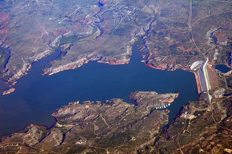
(photo by Doc Searls from Santa Barbara, USA - 2007_08_15)
That's the dam that forms the lake on the far right. If you look just to the left of that on the bottom of the picture there is a shape that looks like a dorky dog with capped teeth running toward the dam. Starting at about the dog's eye and running up his forehead is an oval road. Our campsite is on the lakeside (cliffside is more like it... we're 100' or more above the water level) of that road about 1/3 of the way from the eye to the top of the head.
Here's a pic I took to show how we look there. Pretty good for a free campsite, eh?

And here's a shot taken from the spot just behind the trailer:

So, that's where we are... how did we get there? Well, we started outside of Wichita Falls which is just east of where the Texas panhandle meets the main body of the state. We skirted the Texas/Oklahoma border for a while before entering the panhandle itself and heading northwest. This is where the term "miles and miles of miles and miles" was coined (I'm not positive about that... but I'd bet a few coins it's true). There are signs of really only three things out there... energy, transportation and agriculture. There's a whole lot of this...


For hour after hour we headed northwest through towns with names I've never heard of (Electra, Harold, Vernon, Chillicothe and Quannah) with populations (according to their "Entering ____" signs) as small as 200. About the time we couldn't stand it anymore we reached a major town. You could tell it was major because it had a WalMart Supercenter. It was Childress (I hadn't heard of that one, either). Well, we needed some supplies and we needed lunch so Childress was the choice. We had evidently strayed out of the Tex/Mex zone because the two most highly regarded restaurants in town were both bar-b-que joints. We set the GPS to K. Bryant's Barbecue on Main Street.
All of the streets in old downtown Childress are brick. Nice old western touch. We found 4 contiguous angle-in parking spots on a side street (actually, we could have found four contiguous spots on any side street). We parked the rig, walked Romeo and noticed the large mural next to the trailer. It looked like this:

It depicts the main street of Childress 115 years ago. We walked around the corner to Main St. and saw this:

Aside from the replacement of horses by cars, an updated sign or two and the removal of the oil well on Main St depicted in the mural, this is a town that has not changed in 115 years. We walked up to K Bryants which looks like this:

and went in. The restaurant was nearly empty (it was 2:00 on a Thursday) and huge. It fills what was once a hardware store and the US Post Office. Many of the fixtures from both are still on the walls around the dining room. The brisket was good (not quite as good as in Tyler) and the pulled pork was first rate (as good as my own). The sides left a bit to be desired but it was a worthwhile stop.
After lunch we headed northwest again... aiming for Amarillo. The GPS took us on a country road a bit before the city line. We went right past the main gate of Pantex. That name may not be familiar to you but many of you (particularly the "seasoned citizens" among you who remember school drills that involved hiding under desks to avoid the flash and fallout of the nuclear attack that was sure to hit any day) are familiar with their work. This is the one and only place in the United States where nuclear weapons are assembled and disassembled. Yep... the nuke factory. It sits on 16,000 acres of the sort of country I showed you in the pics above. We pressed on and reached what appeared on the map to be a major intersection about 15 miles outside of Amarillo where I was sure I'd find a gas station (since it had been 45 minutes since I saw one and that was, after all, a major intersection near a city I had heard of and there were people working all around at bomb factories and chicken processors and such). There was not only no gas there, a check with the GPS said the nearest gas was 12 miles in the direction opposite where we were headed. 45 minutes later (and tanked up) we went back through that intersection in the right direction.
So, that's the story of how we reached Sanford-Yake campground on the cliffs above Lake Meredith, TX.
Later...
SC'
No comments:
Post a Comment