Morning, Campers! It's a rare day when I'm writing in the pre-noon hours but today is such a day. I've been messed up a bit with sketchy internet (more on that later) but as we press west into higher elevation, less dense population and more remote locations it's sometimes not even possible to move pictures across the connections.
When I last wrote we were sitting above Lake Meredith north of Amarillo. We had a plan to drive to northeast New Mexico but realized that for about the same drive time we could be in Colorado and shorten the next day's drive, so we changed plans.
On Friday afternoon we landed at Trinidad Lake State Park just outside Trinidad, Colorado. To get there we moved west from Amarillo through more of that energy/agriculture/transportation zone known as the Texas Panhandle. This is tornado alley. The occasional high school along our route for the past couple of days frequently proclaimed their team pride with slogans like "Home of the Cyclones" or "the Truesdale Texas Tornadoes". That just seems to be asking for trouble to me... but it speaks to the land and its people. The motto for the Texas Panhandle may well be "BRING IT!".
We stopped for gas in a small town. I think it was Dalhart, TX -- population 8,326. I have to say that stepping out of the truck the air smelled like energy/agriculture/transportation. There are literally places in the Texas Panhandle where you can smell natural gas while driving on two lane roads through flat, seemingly barren landscape. The derricks are gone - there is no sign of active drilling there - but the collection and distribution infrastructure is visible and the overflow is a constant reminder of the presence of the energy economy. The smell of agriculture is even more present. 18 wheeler cattle carriers have a certain aroma when they pass us on the highway. Even more pronounced is the smell of feed lots and whatever it is they have in town... maybe "manure r us" or something. Anyway, you might get used to it if you hang around a while. I'm still somewhat short of that point. The smells of the Texas Panhandle encourage the newcomer to keep on moving. See what you think:
Northeast New Mexico is a lot like the Texas Panhandle... except without all of that economic activity. We drove an hour without going through a town of more than a couple hundred people. Eventually we reached Raton, New Mexico which sits at the southern end of the Raton Pass on I-25. Historically, this is the route of the Santa Fe Trail which became active as a path from St. Joseph, Missouri to Santa Fe, New Mexico starting in the 1820s. Today it is a route for people from New Mexico and Texas to reach Trinidad, Colorado which, although it has a population of only 9,000 people, has five recreational marijuana dispensaries.
(A note for one faithful reader: Trinidad was founded by Felipe Baca for whom the adjacent county was named. We didn't pass through Baca County, but we got close.)
So, we headed over Raton Pass and into Trinidad. The reason this post uses the work "funky" in its title starts in Trinidad. As I noted above, Trinidad is a small town. What I didn't note above is that it's been slowly loosing population. A drive through old Trinidad shows a once prosperous town center. A touch of that prosperity still shows, but so does the surrounding poverty. Trinidad started as a mining town. No, not gold, not copper, not silver, certainly not uranium back in the day... it was coal mining. I might one day write about the ancestry research I've been doing for both Mrs. C' and me. My roots run deep in coal mining both in Pennsylvania and South Wales. I felt an immediate kinship with Trinidad when I realized the similarity of its people with mine. Digging deeper, Trinidad was the town where Bat Masterson famously acted as Marshall, it was also the home of one of the first hippie communes of the 1960's (Funky!... no, GROOVY). It was also a center of -- brace yourself -- gender reassignment surgery in the 1970's and later. I'll leave you to research that more if you want. In recent years the surgeon who put Trinidad on the map (or took it off... or at least redrew the map) sold his practice to another surgeon who moved it to California. Fitting. Clearly when we crossed the Raton Pass we entered a different place than where we had spent the past few days.
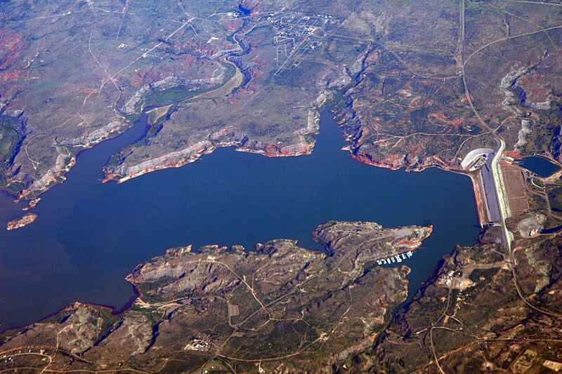
The park itself was nice enough for a one night stand (that didn't sound right... I'll have to work on my phraseology). Here's a shot of the namesake lake taken from near our campsite. Like every lake we've ever stayed at west of the Mississippi River it had a dam at one end.
On Saturday morning we jumped on I-25 to head north with plans to turn west to visit our niece and her family in Del Norte, Colorado. I-25 in the part of Colorado offers a chance to see Colorado's two halves. Most of us easterners think of Colorado as a mountainous state. Certainly, it is that. They even feature a profile of Rocky Mountain peaks in their license plates. But only half the state is mountainous. The eastern half is part of the great American plains. I-25 runs along the boundary between the two. Here's today's Silver Cliche' Driving Experience set to show what I-25 offers in the way of mountain views to the west and plains to the east:
We stopped for lunch in Walsenburg, Colorado where we hopped off I-25 to pick up US 160 heading west. TripAdvisor offered a choice of a drive in, or the restaurant in a B&B in the town center (important note: there are only two sections to Walsenburg: 1. town center and 2. out of town. The town center seemed to be about three blocks in each direction). We picked the B&B. The building appeared to have once been a commercial establishment (dry goods shop, hardware store, grocery, I don't know) but is now a small hotel. Standard fare, friendly small town service. Fuel to keep us going. Here's what "La Plaza" looked like as we wrapped up and hit the road again (it's the blue building on the left).
Another 90 minutes and we were in Del Norte. This is our second visit to this town of about 2,000. It sits in the San Luis valley which is transected by the Rio Grande River. Despite the connotations that the Rio Grande may have in other places (including the White House), here it isn't a border but it brings life to this valley. The valley is about 120 miles wide (east to west) and nearly 80 miles north to south. Del Norte (which we had to come here to learn is pronounced by the current locals as if it was an English combo -- "del nort" -- and not the way some earlier locals, or San Luis himself might have pronounced it -- "del nortay") is located on the far western end of the valley which is where the Rio Grande enters from the San Juan mountains where it's headwaters are found . The valley's most striking feature to me is the agriculture which can best be seen and appreciated from the Google Maps satellite view. Let me show you:
This is a dry place and high dessert (over 7,500 feet above sea level). The native vegetation includes hearty things like sagebrush and tumbleweeds. If you look at the picture above that's not what you see. Every green circle is the location of an irrigation system. The ones here are 360 degree rotating types with arms that seem to be about 1/2 mile long. Those dots are agriculture enabled by the roughly 1 mile diameter irrigation swaths fed by the water from the Rio Grande. I didn't count them in the pic above, but I did a rough count of 50 circles across by 70 up and down with roughly half of the available spots on that 50x70 grid being in use. That's 1,750 irrigation points. Trust me, agriculture is big here. So are water rights!
Here's a shot I took this morning looking north across the short end of the San Luis Valley from our parking spot just west of Del Norte.
This afternoon for yucks we drove to the nearby town of Creede. This is a former mining town (no, not coal...silver this time) on the Rio Grande about 20 miles into the San Juan mountains from the western end of the San Luis Valley. The main product is the extraction of silver (coins that is... and dollar bills too while you're at it) from the pockets of California and Texas people who want to live in an olde western town. I don't have a problem with that. Here are a couple of shots of the mining industry remnants of Creede, Colorado.
So, about that sketchy connectivity... we are out in the sticks... the population density in Del Norte is roughly equal to the Sahara or the Moon. So, with low population density comes few cell towers. This is the first time this trip we've really been out of communication. However, with a bit of technology we carry (20 foot tall telescoping antenna mast, cell phone booster and two cell phone booster antennas that attach to the mast, we are occasionally able to connect and draw enough bandwidth to reach civilization. Thanks to all of that, you are able to read all of this.
Tomorrow we roll on. We had planned to visit Pueblo, Colorado but were advised that Pueblo is the Cleveland of Colorado (I don't think they were meaning that favorably). So, we may head north to Salida -- a town we visited last year and enjoyed for a few hours -- for a night before moving on to Colorado Springs.
Stay tuned for more!
SC'
Sunday, May 7, 2017
Friday, May 5, 2017
Goin' small in a big state
(written Thursday evening, edited and posted Friday)
Evenin' Campers! It's Silver Cliche' with you again tonight. It's our last night in Texas for this trip and we,have a,beautiful spot at The Sanford-Yake Campground in the Lake Meredith National Recreation Area. When you take that apart what it means is we are on Federal land in a campsite built with your tax dollars as part of the project that impounded the Canadian River to form Lake Meredith. There is no water hookup or electric at the site, but it's got a great view. Here... let me show you a couple of shots just to get the pictures flowing early tonight:. Here's an aerial view of the lake provided on the Wikipedia website:
.

(photo by Doc Searls from Santa Barbara, USA - 2007_08_15)
That's the dam that forms the lake on the far right. If you look just to the left of that on the bottom of the picture there is a shape that looks like a dorky dog with capped teeth running toward the dam. Starting at about the dog's eye and running up his forehead is an oval road. Our campsite is on the lakeside (cliffside is more like it... we're 100' or more above the water level) of that road about 1/3 of the way from the eye to the top of the head.
Here's a pic I took to show how we look there. Pretty good for a free campsite, eh?
And here's a shot taken from the spot just behind the trailer:
and this...
and this...
but mostly this....
For hour after hour we headed northwest through towns with names I've never heard of (Electra, Harold, Vernon, Chillicothe and Quannah) with populations (according to their "Entering ____" signs) as small as 200. About the time we couldn't stand it anymore we reached a major town. You could tell it was major because it had a WalMart Supercenter. It was Childress (I hadn't heard of that one, either). Well, we needed some supplies and we needed lunch so Childress was the choice. We had evidently strayed out of the Tex/Mex zone because the two most highly regarded restaurants in town were both bar-b-que joints. We set the GPS to K. Bryant's Barbecue on Main Street.
All of the streets in old downtown Childress are brick. Nice old western touch. We found 4 contiguous angle-in parking spots on a side street (actually, we could have found four contiguous spots on any side street). We parked the rig, walked Romeo and noticed the large mural next to the trailer. It looked like this:
It depicts the main street of Childress 115 years ago. We walked around the corner to Main St. and saw this:
and went in. The restaurant was nearly empty (it was 2:00 on a Thursday) and huge. It fills what was once a hardware store and the US Post Office. Many of the fixtures from both are still on the walls around the dining room. The brisket was good (not quite as good as in Tyler) and the pulled pork was first rate (as good as my own). The sides left a bit to be desired but it was a worthwhile stop.
After lunch we headed northwest again... aiming for Amarillo. The GPS took us on a country road a bit before the city line. We went right past the main gate of Pantex. That name may not be familiar to you but many of you (particularly the "seasoned citizens" among you who remember school drills that involved hiding under desks to avoid the flash and fallout of the nuclear attack that was sure to hit any day) are familiar with their work. This is the one and only place in the United States where nuclear weapons are assembled and disassembled. Yep... the nuke factory. It sits on 16,000 acres of the sort of country I showed you in the pics above. We pressed on and reached what appeared on the map to be a major intersection about 15 miles outside of Amarillo where I was sure I'd find a gas station (since it had been 45 minutes since I saw one and that was, after all, a major intersection near a city I had heard of and there were people working all around at bomb factories and chicken processors and such). There was not only no gas there, a check with the GPS said the nearest gas was 12 miles in the direction opposite where we were headed. 45 minutes later (and tanked up) we went back through that intersection in the right direction.
So, that's the story of how we reached Sanford-Yake campground on the cliffs above Lake Meredith, TX.
Later...
SC'
Evenin' Campers! It's Silver Cliche' with you again tonight. It's our last night in Texas for this trip and we,have a,beautiful spot at The Sanford-Yake Campground in the Lake Meredith National Recreation Area. When you take that apart what it means is we are on Federal land in a campsite built with your tax dollars as part of the project that impounded the Canadian River to form Lake Meredith. There is no water hookup or electric at the site, but it's got a great view. Here... let me show you a couple of shots just to get the pictures flowing early tonight:. Here's an aerial view of the lake provided on the Wikipedia website:
.
(photo by Doc Searls from Santa Barbara, USA - 2007_08_15)
That's the dam that forms the lake on the far right. If you look just to the left of that on the bottom of the picture there is a shape that looks like a dorky dog with capped teeth running toward the dam. Starting at about the dog's eye and running up his forehead is an oval road. Our campsite is on the lakeside (cliffside is more like it... we're 100' or more above the water level) of that road about 1/3 of the way from the eye to the top of the head.
Here's a pic I took to show how we look there. Pretty good for a free campsite, eh?
And here's a shot taken from the spot just behind the trailer:
So, that's where we are... how did we get there? Well, we started outside of Wichita Falls which is just east of where the Texas panhandle meets the main body of the state. We skirted the Texas/Oklahoma border for a while before entering the panhandle itself and heading northwest. This is where the term "miles and miles of miles and miles" was coined (I'm not positive about that... but I'd bet a few coins it's true). There are signs of really only three things out there... energy, transportation and agriculture. There's a whole lot of this...
and this...
and this...
but mostly this....
For hour after hour we headed northwest through towns with names I've never heard of (Electra, Harold, Vernon, Chillicothe and Quannah) with populations (according to their "Entering ____" signs) as small as 200. About the time we couldn't stand it anymore we reached a major town. You could tell it was major because it had a WalMart Supercenter. It was Childress (I hadn't heard of that one, either). Well, we needed some supplies and we needed lunch so Childress was the choice. We had evidently strayed out of the Tex/Mex zone because the two most highly regarded restaurants in town were both bar-b-que joints. We set the GPS to K. Bryant's Barbecue on Main Street.
All of the streets in old downtown Childress are brick. Nice old western touch. We found 4 contiguous angle-in parking spots on a side street (actually, we could have found four contiguous spots on any side street). We parked the rig, walked Romeo and noticed the large mural next to the trailer. It looked like this:
It depicts the main street of Childress 115 years ago. We walked around the corner to Main St. and saw this:
Aside from the replacement of horses by cars, an updated sign or two and the removal of the oil well on Main St depicted in the mural, this is a town that has not changed in 115 years. We walked up to K Bryants which looks like this:
and went in. The restaurant was nearly empty (it was 2:00 on a Thursday) and huge. It fills what was once a hardware store and the US Post Office. Many of the fixtures from both are still on the walls around the dining room. The brisket was good (not quite as good as in Tyler) and the pulled pork was first rate (as good as my own). The sides left a bit to be desired but it was a worthwhile stop.
After lunch we headed northwest again... aiming for Amarillo. The GPS took us on a country road a bit before the city line. We went right past the main gate of Pantex. That name may not be familiar to you but many of you (particularly the "seasoned citizens" among you who remember school drills that involved hiding under desks to avoid the flash and fallout of the nuclear attack that was sure to hit any day) are familiar with their work. This is the one and only place in the United States where nuclear weapons are assembled and disassembled. Yep... the nuke factory. It sits on 16,000 acres of the sort of country I showed you in the pics above. We pressed on and reached what appeared on the map to be a major intersection about 15 miles outside of Amarillo where I was sure I'd find a gas station (since it had been 45 minutes since I saw one and that was, after all, a major intersection near a city I had heard of and there were people working all around at bomb factories and chicken processors and such). There was not only no gas there, a check with the GPS said the nearest gas was 12 miles in the direction opposite where we were headed. 45 minutes later (and tanked up) we went back through that intersection in the right direction.
So, that's the story of how we reached Sanford-Yake campground on the cliffs above Lake Meredith, TX.
Later...
SC'
Thursday, May 4, 2017
Tech troubles... gone fishin'
Hey everyone, SilverCliche' here... from the shores of Lake Meredith, Texas. We have cell service and internet but we're not plugged in nor running generators, so I've got no 110 volt power and that means no PC. Blogger and the iPad seem to be at war. Look for a double post tomorrow night.
Later...
SC'
Later...
SC'
Wednesday, May 3, 2017
And suddenly it all changed
Evenin' Campers! It's Silver Cliche' with you again tonight. I'm writing from north central Texas, just south of Wichita Falls at Arrowhead Lake State Park.
I promised last night that I'd probably be brief tonight. I think I can keep that promise but with the aid of many pictures.
The day started in the upper 60's, overcast and humid at Tyler State Park. The coffee and crossword session was enjoyable. The new extendable cell phone booster antenna mast (Mrs. C' doesn't much like my technology prototypes... but she sometimes likes the results... and this is in that category) was put to the test and performed perfectly. It's a 20' flag pole in 7 segments that collapses to under 4 feet. I snap a magnetic base cell phone antenna to it, raise it, bungee to the awning supports of the trailer, hook the 30' coax cable to the booster inside the trailer and... voila!... three bars of 4G LTE connectivity where previously there was a 1X or 3G signal at one or two bars. We're streaming Lester Holt where other people have resorted to tiddlywinks and dominoes (I'm not saying our camping experience is more "authentic"... only that the tech we carry works).
We pushed off at about 10:00 and headed west toward the "Big D"... Dallas. On the way we passed through Canton, TX which was in the news over the weekend as it was hit by tornadoes. The damage was visible even from the interstate and in particular we saw two adjacent buildings at what appeared to be a used car lot on an adjacent road that were shredded as if bomb had hit them. Sobering.
Navigating the Airstream around Dallas and through Ft. Worth in a downpour with construction everywhere was the challenge it sounds like. Piloting an 8'6" vehicle through two lane stretches and lane shifts with lanes of about 9'6" with jersey barriers on the left and right has its white knuckle moments. When we made a gas stop shortly after Ft. Worth I walked around the Airstream to see it there were any scrapes or dents telling me I got a bit too close. It was all good. Phew... getting Airstream body work done usually necessitates a trip back to the factory in Jackson Center, Ohio.
Once clear of urbanity I checked the GPS for the next major town... Decatur... and Tripadvisor showed the top restaurant was Casa Torres Mexican Restaurant. As the title of today's blog says... everything had changed. This was the first sign. If you've been following along you might notice the steady shift in food as we "eat local". Although we didn't eat there, the typical top choice among Florida diners is Cracker Barrel. I'm not kidding you. This says a lot about Florida and Floridians. I feel no need to elaborate for you. When we got to Alabama we ate gulf seafood, in Louisiana it was Cajun... especially the fried variety, yesterday in East Texas it was bar-b-que and finally in North Texas we hit Mexican. The patrons of Casa Torres had left just enough spots next to each other for us to park the rig (I didn't count there, but usually we take up 7 adjacent spots when we park across the grain in "head in" parking spots). Lunch was winding down. People with inferior vehicles still had plenty of spaces for their puny machines. Romeo feels like a king owning a corner of a parking lot and hanging in the trailer while we eat.Here's our fajita combo for two and a pic of my sopapilla. That's butter on it (never had it that way before... will always do it in the future) and a bottle of honey behind the plate. Fried dough with butter (to raise the fat component) and honey. There's no way that can miss.
That wasn't the only change. While we were overwhelmed by the presence of the Dallas/Ft.Worth metroplex the surrounding terrain had changed. By the time we stopped lunch we were out of the eastern US forests and into the Great Plains. Vegetation was sparse and low. The land itself was flat. Although Mrs. C' objects every time I do this, I felt compelled to share with you the first "Silver Cliche' Driving Experience" of this trip. Taken on US 287 between Decatur and Wichita Falls, Texas heading northwest at 2:30 PM local time. This is what one sees out the driver's side window, windshield and passenger window:
Tall trees? Gone! Rolling hills? Behind us! Major rivers? Dried up! You[re in the Great Plains now. The emphasis belongs on plain. Out here they just call it Tix-s as in "Weelcome to noth Tix-s. Hire y'all?"
We sped along to Wichita Falls. Actually, we jumped off the big road just short of Wichita Falls to head to the campground. We'll pass through there tomorrow on the way to Amarillo. The plains in Texas have a charm and beauty. Sometimes you have to look closely to spot it, but it's there. I took a few pics in the late afternoon after we settled in. See what you think. Here are two easy ones...
It's thistle season!
Here's what the Airstream looks like settled among the mesquite:
A short walk from the campsite took me to the top of a man made ridge. I'm guessing its flood control, but it provided a vantage point for me to share a view of the dominant terrain and vegetation... flat and mesquite:
If you ever had conscience pangs that your Boar's Head Mesquite Smoked Chicken habit was somehow endangering mesquite, get over it. This part of Texas has more mesquite than Colorado has snowflakes. Nosh on!
So, that's it for today. Tomorrow we press on to the Amarillo area. We have no reservation but there are three campgrounds we can pick from. I'm thinking we'll wind up on Lake Meredith near Sanford, Texas in the Lake Meredith National Recreation Area. It's "dry camping" (no water, no electricity) but free courtesy of the National Park Service (that's you... thanks again for making this possible!). We may not have internet out in the boonies, but heaven knows the antenna will be up and I'll be messing with wires until I've exhausted every possibility!
Until next time...
SC'
I promised last night that I'd probably be brief tonight. I think I can keep that promise but with the aid of many pictures.
The day started in the upper 60's, overcast and humid at Tyler State Park. The coffee and crossword session was enjoyable. The new extendable cell phone booster antenna mast (Mrs. C' doesn't much like my technology prototypes... but she sometimes likes the results... and this is in that category) was put to the test and performed perfectly. It's a 20' flag pole in 7 segments that collapses to under 4 feet. I snap a magnetic base cell phone antenna to it, raise it, bungee to the awning supports of the trailer, hook the 30' coax cable to the booster inside the trailer and... voila!... three bars of 4G LTE connectivity where previously there was a 1X or 3G signal at one or two bars. We're streaming Lester Holt where other people have resorted to tiddlywinks and dominoes (I'm not saying our camping experience is more "authentic"... only that the tech we carry works).
We pushed off at about 10:00 and headed west toward the "Big D"... Dallas. On the way we passed through Canton, TX which was in the news over the weekend as it was hit by tornadoes. The damage was visible even from the interstate and in particular we saw two adjacent buildings at what appeared to be a used car lot on an adjacent road that were shredded as if bomb had hit them. Sobering.
Navigating the Airstream around Dallas and through Ft. Worth in a downpour with construction everywhere was the challenge it sounds like. Piloting an 8'6" vehicle through two lane stretches and lane shifts with lanes of about 9'6" with jersey barriers on the left and right has its white knuckle moments. When we made a gas stop shortly after Ft. Worth I walked around the Airstream to see it there were any scrapes or dents telling me I got a bit too close. It was all good. Phew... getting Airstream body work done usually necessitates a trip back to the factory in Jackson Center, Ohio.
Once clear of urbanity I checked the GPS for the next major town... Decatur... and Tripadvisor showed the top restaurant was Casa Torres Mexican Restaurant. As the title of today's blog says... everything had changed. This was the first sign. If you've been following along you might notice the steady shift in food as we "eat local". Although we didn't eat there, the typical top choice among Florida diners is Cracker Barrel. I'm not kidding you. This says a lot about Florida and Floridians. I feel no need to elaborate for you. When we got to Alabama we ate gulf seafood, in Louisiana it was Cajun... especially the fried variety, yesterday in East Texas it was bar-b-que and finally in North Texas we hit Mexican. The patrons of Casa Torres had left just enough spots next to each other for us to park the rig (I didn't count there, but usually we take up 7 adjacent spots when we park across the grain in "head in" parking spots). Lunch was winding down. People with inferior vehicles still had plenty of spaces for their puny machines. Romeo feels like a king owning a corner of a parking lot and hanging in the trailer while we eat.Here's our fajita combo for two and a pic of my sopapilla. That's butter on it (never had it that way before... will always do it in the future) and a bottle of honey behind the plate. Fried dough with butter (to raise the fat component) and honey. There's no way that can miss.
That wasn't the only change. While we were overwhelmed by the presence of the Dallas/Ft.Worth metroplex the surrounding terrain had changed. By the time we stopped lunch we were out of the eastern US forests and into the Great Plains. Vegetation was sparse and low. The land itself was flat. Although Mrs. C' objects every time I do this, I felt compelled to share with you the first "Silver Cliche' Driving Experience" of this trip. Taken on US 287 between Decatur and Wichita Falls, Texas heading northwest at 2:30 PM local time. This is what one sees out the driver's side window, windshield and passenger window:
Tall trees? Gone! Rolling hills? Behind us! Major rivers? Dried up! You[re in the Great Plains now. The emphasis belongs on plain. Out here they just call it Tix-s as in "Weelcome to noth Tix-s. Hire y'all?"
We sped along to Wichita Falls. Actually, we jumped off the big road just short of Wichita Falls to head to the campground. We'll pass through there tomorrow on the way to Amarillo. The plains in Texas have a charm and beauty. Sometimes you have to look closely to spot it, but it's there. I took a few pics in the late afternoon after we settled in. See what you think. Here are two easy ones...
Here's what the Airstream looks like settled among the mesquite:
A short walk from the campsite took me to the top of a man made ridge. I'm guessing its flood control, but it provided a vantage point for me to share a view of the dominant terrain and vegetation... flat and mesquite:
If you ever had conscience pangs that your Boar's Head Mesquite Smoked Chicken habit was somehow endangering mesquite, get over it. This part of Texas has more mesquite than Colorado has snowflakes. Nosh on!
So, that's it for today. Tomorrow we press on to the Amarillo area. We have no reservation but there are three campgrounds we can pick from. I'm thinking we'll wind up on Lake Meredith near Sanford, Texas in the Lake Meredith National Recreation Area. It's "dry camping" (no water, no electricity) but free courtesy of the National Park Service (that's you... thanks again for making this possible!). We may not have internet out in the boonies, but heaven knows the antenna will be up and I'll be messing with wires until I've exhausted every possibility!
Until next time...
SC'
Tuesday, May 2, 2017
Layin' low in Tyler
Evenin' Campers! It's Silver Cliche' here with you again tonight and for the second night in a row from quiet Tyler State Park, Texas!
It was a low, slow day for Mrs. C', Romeo and me today, so I'll make this brief and focus on a bit of catch up on a few stray thoughts from the past days. The battlefields of the Civil War are behind us, there don't seem to be any World Heritage Sites nearby and the weather was perfect today (low overnight in the upper 50's, high in the 80's, dry air, no rain, light breezes... we could use more like this). Best of all, this was the first day we didn't hitch up and drag the trailer across some forsaken stretch of America!
Taking the day off reminded me how hard some of the routes we've taken have been on man and machine (and woman... and dog). The worst of all thus far had to be I-20 in Louisiana. Among the Airstream community online, Louisiana has a reputation for damaging hardware and breaking the spirit of travelers. Most of I-20 was concrete. You may know that concrete highways are cast in place in slabs that abut one another... thousands and thousands of slabs. The spacing of the joints in those slabs and whether the slabs stay in a plane over time makes all the difference for the comfort of the long distance traveler. When Louisiana put down the roadway for I-20 (I'm thinking that was sometime in the Eisenhower Administration) they asked themselves two questions: 1.) what is the worst possible spacing between joints to set up a nasty harmonic that will shake loose anything not bolted, glued and bungee corded down in a 20' long truck pulling a 25' long Airstream moving at 65 miles per hour and 2.) how can we compact the underlayment for this road such that every slab sinks two inches on its eastern edge while remaining in place on the west? Despite what you may think about the people of Louisiana let me say this concerning those two questions: On #1: NAILED IT! and on #2: NAILED IT! At one point I was driving 45 mph in a 60 MPH zone purely to keep the truck and trailer from going airborne like a porpoise at Marineland. You may know that doctors and nurses who work with children in clinics, pediatrician's offices and hospital ER's are trained to look for the signs of physical abuse of children. Sad, but necessary and potentially lifesaving assessments are made and caregivers asked questions like "Has someone been hitting little Mary?". Well, in Louisiana if a child is examined and shows signs of bruising on the back of the head, elbows, buttocks and backs of the thighs a doctor may well ask "Y'all haven't been drahvin' this child in the cawr on an Innahstaet, have y'all?". Last year I wrote about the very visible effect that the legalization of recreational marijuana has had on the roads of Colorado. Tax revenue well spent is a wonderful thing. If I get a vote on which state most needs that extra shot of road-juice my vote goes to Louisiana!
Anyway... back to Texas. East Texas where we are now is the site of the earliest serious efforts at oil exploration, extraction and refining. The pride still shows. I even noticed little oil derricks over each picnic bench at a highway rest stop on I-20 in Texas (much smoother than Louisiana...and it was done with oil money... no weed needed). There were oil pumps set as if they were stone pillars marking the entrance to a gas station near the park.
Today we went into Tyler for a few errands and some chow. I was struck by a thought that hit me in Tallahassee, Shreveport and who knows how many other towns. Avid readers (ok... avid reader) may recall that last year I described a rural pattern that repeats in virtually every state in the US that we have visited. It mixes formerly tilled farmland with modest houses, flashing yellow traffic lights on county roads and long abandoned gas stations with the occasional Dollar General store. I called that pattern "Americountry" and we've seen it everywhere on this trip just as we have on others. Well, today while driving down South Broadway in Tyler, Texas to coin a term for its grown-up cousin. There is a pattern on the outskirts of the old central town space where new businesses cluster. This is where the Home Depot, Marshalls, KFC, Holiday Inn Express and countless other businesses land. I'm sure you got this in your town. The road is predictably three travel lanes in each direction. Sometimes there's a median, often there is a left turn area shared by both directions and in its most advanced form there are left turn lanes (yep... more than one!) at intersections to keep it movin'. Here's a pic I grabbed from Google (that's a picture credit) to show you what I saw today:
From here on I'll refer to this space (which is where we frequently gas up the trusty Tundra and ourselves on travel days) as "the Americle Mile". See if you can recognize the pattern in your town.
Just to make sure we had an authentic Tyler experience we left South Broadway... I mean... the Americle Mile of Tyler and headed in to the old part of town. The attraction was what I understand to be the oldest continuously operated family run bar-b-que joint in Texas. Trust me on this... there's a lot of bar-b-que joints in Texas. Even if they have to get awkward with the definition, its a superlative in a huge field. The reviews were great and I was impressed when I saw this as we approached:
That's the trusty Tundra in the foreground... hogging the shot... sorry, I was too excited to move her before taking the shot. The sign is about 60 years old. The building is probably older. The area just in front of the truck is the outdoor seating which is on very sturdy old picnic tables. If I was to rate Stanleys on initial appearance versus other dive bar-b-que joints I've been to I'd give it an 87 or 88. It's got the age (old), condition (we don't give a crap about the building... we're bar-b-que people), appointments (outdoor seating is a must for authenticity even in a climate with high temps over 100 and a mild threat of mosquito borne illnesses). It might have scored higher but I didn't see any sign of unrepaired fire damage to the building nor nail holes in the door frame indicating the health department had barred the door over some unfortunate misunderstanding about the condition of the kitchen. I entered hopefully. The next plus was the menu. I forgot to snap a pic. There was nothing that didn't belong there. If you don't want bar-b-que, Stanley doesn't want you. Good attitude! There was no salad with meat topping, no meat in a spinach wrap, no veggie burger ("for our vegan friends!"). If you didn't care for smoked meat you were going hungry here. I ordered the two meat platter (sliced beef brisket and pulled pork) and Mrs. C' ordered the sliced brisket sandwich. Both came on plastic trays covered with a waxed paper (add 3 points to the score!) the sandwich was meat on a hamburger bun... that's it (add 2 more points!). The meat platter was... well... see for yourself (sorry, I took a couple of bites before thinking of you):
Clockwise from top left: cole slaw slammed on the plate with an ice cream scoop, two slices of white bread, potato salad with a touch of mustard and pickles in the mix, the pulled pork, the sliced brisket and pinto beans. The pork was Texas style. Some of you know I fancy myself a pork shoulder smoker of some capability. I cook southern style. That said, they did it right. It's like meeting a relative from another part of the country. They may have a different accent (black pepper in this case) but the family resemblance and quality of the gene line tops that. The stars of the show were the brisket and beans. The beef was hands down, bar none the best bar-b-que beef I have ever had. I've been reluctant to smoke brisket myself since I've never had any that was worth the work. That changed today for me. You can know that the smoker at home will be packed with brisket before the summer is over. As for the beans, I'm an aficionado of Cuban style black beans (I have 4 containers of my secret recipe in the trailer freezer right now to address any cravings on this long trip) and my red beans and rice recipe is nearing the goal (I keep leftover bar-b-qued pork shoulder in the freezer since its essential to southern style red beans). I've never made pinto beans, but this is a recipe worth emulating. It was all bean and sauce, no fancy stuff. Not sweet, no hunks of anything (veggies, pork belly, whatever people throw into beans... there wasn't any). Just beans. I respect that.
In case you feel like I do, here's a close up of that bar-b-que (close your eyes if you're a vegan... this will be too close to eating meat for you!)
OK... so it wasn't brief. I'll try to make up for that tomorrow. And what's on the agenda? Well, we pack up here in Tyler, hitch the wagon to the tow and continue west. We will take the southern route around Dallas which means going through Arlington and Ft. Worth. I'll hold my breath as we pass AT&T stadium (the stench almost got me last year) then we enter the plains and head for Wichita Falls and Lake Arrowhead State Park. We were supposed to stay there last year but they called and told us that the park had been flooded and was closed. I'm hoping the water has receded. I'm also hoping they took time to renovate with the place was offline!
Until then....
SC'
Monday, May 1, 2017
Across the boot and into the star
Evenin' Campers! It's Silver Cliche' with you again tonight and tonight from the Lone Star State! We're not exactly "deep in the heart" of Texas, but we are at least "a bit removed from Louisiana".
So... After a long day and tales of Vicksburg yesterday I was spent and left you hanging with a promise to share a total surprise we encountered in Louisiana. I'll pick up where I left off. We departed the state of Mississippi yesterday afternoon by crossing a bridge spanning it's namesake river and carrying I-20 traffic. If you think of Louisiana being shaped like a boot (no... it's not one of those tall women's boots like Italy... its more of the "just above the ankle" variety that hunters, farmers and exurban slush-haters wear... but it's a boot none the less) then we entered the state through the second eyelet from the top. I-20 makes a straight line across the state from that point as if a cobbler had stitched it. We were about 50 miles in when we reached the exit for our campground. If you've ever driven the land just west of the Mississippi river in Louisiana, Arkansas and even into Missouri you may recall that the land is flat, flat, flat. Its been planed smooth by millions of spring floods and is chock full of agriculture. We were still in that flood plain when we exited I-20. At our exit were two brown signs with white lettering. One said "Poverty Point State Park". That was us. The other said "Poverty Point World Heritage Site". What? I am familiar with world heritage sites. That status is granted by UNESCO (that's the United Nations... ah... Earth (I think).... no Ecology.... oh, who cares?... it's the United Nations ESCO group... they're important... trust me... at least for this story they're important). There are approximately 1,000 sites at present and they represent the most significant natural and man made points on the planet. The list includes places like the Great Barrier Reef and Sydney Opera House in Australia (noteworthy... right?). The Great Wall of China. The pyramids of Egypt. Stonehenge. You get the idea. What in the name of God was a World Heritage Site doing on the Mississippi flood plain near our humble state park campground? There are only 23 of these sites in the whole US-of-A... less than one for every two states... and there is one here and I've never heard of it? That all turned out to be true.
Just a few miles from the campground sits the "Monumental Earthworks of Poverty Point". Here is the best pic I could find online to capture the site:
The features that make this noteworthy are the arcs. They are mounds built with significant precision beginning 3,700 year ago and developed over about 600 years, then abandoned, then added on to again, then forgotten completely until being discovered after Europeans colonized the area (and as you can see, those Europeans used bulldozers to put a road through the pesky mounds). The mounds stand up to 30 feet high today and are over a kilometer long. If you allow for nearly 4,000 years of settling and compaction including a few floods then when they were built they were... well... I guess... much taller. Some of the objects and material that has come out of the site came from as far as 800 miles away. There are 53 million cubic feet of material in the ridges and they were built at a time after the Egyptian pyramids but before the Mayan pyramids in Central America by people who were hunter gatherers and had no "machines" (including wheeled devices). Somehow, between sessions chasing bison, noodling fish and gathering fiddleheads these people moved tens of millions of basket loads of dirt to make a structure that looks like ripples on a pond. Well I'll be darned.
So, with the sun halfway to its zenith for the day we pressed on west, across the "boot state" and headed for its third largest city -- Shreveport. The trip was uneventful (our favorite kind!). Shreveport is a city of just under 200,000 population sitting on the Red River. Based on the significant number of billboards along I-20 as we approached the city, it's principle industries are gambling and the practice of personal injury law. In reality there is actually some other stuff happening there including transportation (the Red River is navigable all the way to Wichita Falls, Texas which is over 325 miles away). The other major industry in Shreveport is the serving foods that people in most other parts of the country refuse to eat. Naturally, we jumped in! The top rated restaurant in Shreveport according to TripAdvisor is Crawdaddy's Kitchen. We went! Here are a few pics from that experience which is best described as "an experience".
That's the fried oysters on the left and the fried crawfish tails on the right. Everything we got tasted like "fried". We sampled the gumbo which tasted like "spicy" and the etouffee which tasted like "shrimpy". Like I said, it was an experience.
So after lunch we wandered out of Louisiana and into Texas. We are at Tyler State Park just outside of Tyler. Tomorrow is our first day off the road for this trip. We'll visit Tyler and do a bit of shopping to replenish our stores before making two more stops in Texas, one in New Mexico then landing on Colorado for a couple day visit with Mrs. C's neice.
I'll leave you with two shots from Tyler State Park. Today was the first day of the trip where the weather could be described as "beautiful".
Until tomorrow...
SC'
So... After a long day and tales of Vicksburg yesterday I was spent and left you hanging with a promise to share a total surprise we encountered in Louisiana. I'll pick up where I left off. We departed the state of Mississippi yesterday afternoon by crossing a bridge spanning it's namesake river and carrying I-20 traffic. If you think of Louisiana being shaped like a boot (no... it's not one of those tall women's boots like Italy... its more of the "just above the ankle" variety that hunters, farmers and exurban slush-haters wear... but it's a boot none the less) then we entered the state through the second eyelet from the top. I-20 makes a straight line across the state from that point as if a cobbler had stitched it. We were about 50 miles in when we reached the exit for our campground. If you've ever driven the land just west of the Mississippi river in Louisiana, Arkansas and even into Missouri you may recall that the land is flat, flat, flat. Its been planed smooth by millions of spring floods and is chock full of agriculture. We were still in that flood plain when we exited I-20. At our exit were two brown signs with white lettering. One said "Poverty Point State Park". That was us. The other said "Poverty Point World Heritage Site". What? I am familiar with world heritage sites. That status is granted by UNESCO (that's the United Nations... ah... Earth (I think).... no Ecology.... oh, who cares?... it's the United Nations ESCO group... they're important... trust me... at least for this story they're important). There are approximately 1,000 sites at present and they represent the most significant natural and man made points on the planet. The list includes places like the Great Barrier Reef and Sydney Opera House in Australia (noteworthy... right?). The Great Wall of China. The pyramids of Egypt. Stonehenge. You get the idea. What in the name of God was a World Heritage Site doing on the Mississippi flood plain near our humble state park campground? There are only 23 of these sites in the whole US-of-A... less than one for every two states... and there is one here and I've never heard of it? That all turned out to be true.
Just a few miles from the campground sits the "Monumental Earthworks of Poverty Point". Here is the best pic I could find online to capture the site:
The features that make this noteworthy are the arcs. They are mounds built with significant precision beginning 3,700 year ago and developed over about 600 years, then abandoned, then added on to again, then forgotten completely until being discovered after Europeans colonized the area (and as you can see, those Europeans used bulldozers to put a road through the pesky mounds). The mounds stand up to 30 feet high today and are over a kilometer long. If you allow for nearly 4,000 years of settling and compaction including a few floods then when they were built they were... well... I guess... much taller. Some of the objects and material that has come out of the site came from as far as 800 miles away. There are 53 million cubic feet of material in the ridges and they were built at a time after the Egyptian pyramids but before the Mayan pyramids in Central America by people who were hunter gatherers and had no "machines" (including wheeled devices). Somehow, between sessions chasing bison, noodling fish and gathering fiddleheads these people moved tens of millions of basket loads of dirt to make a structure that looks like ripples on a pond. Well I'll be darned.
So, with the sun halfway to its zenith for the day we pressed on west, across the "boot state" and headed for its third largest city -- Shreveport. The trip was uneventful (our favorite kind!). Shreveport is a city of just under 200,000 population sitting on the Red River. Based on the significant number of billboards along I-20 as we approached the city, it's principle industries are gambling and the practice of personal injury law. In reality there is actually some other stuff happening there including transportation (the Red River is navigable all the way to Wichita Falls, Texas which is over 325 miles away). The other major industry in Shreveport is the serving foods that people in most other parts of the country refuse to eat. Naturally, we jumped in! The top rated restaurant in Shreveport according to TripAdvisor is Crawdaddy's Kitchen. We went! Here are a few pics from that experience which is best described as "an experience".
So after lunch we wandered out of Louisiana and into Texas. We are at Tyler State Park just outside of Tyler. Tomorrow is our first day off the road for this trip. We'll visit Tyler and do a bit of shopping to replenish our stores before making two more stops in Texas, one in New Mexico then landing on Colorado for a couple day visit with Mrs. C's neice.
I'll leave you with two shots from Tyler State Park. Today was the first day of the trip where the weather could be described as "beautiful".
Until tomorrow...
SC'
Subscribe to:
Comments (Atom)


