Evenin' Campers!
It's Silver Cliche' here with you again. Still camped at Tetilla
Peak Recreation Area on Cochiti Lake between Albuquerque and Santa
Fe, New Mexico.
Today was one of
those treasured days for us where we didn't have to hitch up, didn't
have to prep the trailer for the road (anything forgotten and left
loose becomes a projectile), didn't have to stop at the dump station,
etc.. Instead, we enjoyed pancakes and lingered extra long on the
newspaper and coffee. The night was cool (for Floridians) but
pleasant. It was in the low 50's at daybreak with a promise to warm
to the low 70's and clear with less wind than yesterday (technically,
tropical storms have less wind than yesterday, so we didn't think
much of the weatherman's commitment to send us reduced winds).
I don't often talk
about photography. I enjoy watching and waiting for the right moment
to make an attempt at capturing what I see in these places we travel
and sharing them with you. I especially look for sunrise and sunset
shots (check out Flickr page if you want proof:
https://www.flickr.com/photos/131457232@N02/ ) Sometimes I'm up and
out before the sun (carrying a cup of coffee of course) to get the
pics I want. This campsite has great views from just outside the
door of the trailer, and they are looking to the west from our location.
Yesterday I posted on Flickr and here a shot of the afternoon looking
west. Here it is again:

This morning I got a
chance to reshoot that view and make a panorama as the sun hit the
Sandia peaks near Albuquerque on the left and the closer peaks of Los Alamos on the right of the frame. I
like this better because the morning air is clearer, the contrast
between sun and shade adds interest and the color of the morning sun
brings life to the hillsides. I hope you like it too:

And finally, because
I like to serve you, my readers, with the freshest photography in the
entire state of New Mexico, here is the same shot taken moments ago
as the sun has completely set and a crescent moon is about to follow
it below the western horizon:

Occasionally on
these trips we get a chance to visit people along the way. Today was
one of those days. We drove into Albuquerque to visit and have lunch
with my brother and his wife. A great visit it was. We met at their
house and had a chance to share family news and pictures. I think
this was the first time it dawned on me that every time we get
together with folks we all pull out and pass around some electronic
device. We looked at iPads, iPhones, AirBooks, Androids… you name
it. I'm sure glad I balked when my stock broker recommended investing
in Kodak and a new photo album company a few years back. We talked
about fishing, Airstreams, kids, grand kids. It was great to catch up.
We had a good laugh
about a major invention of the 1980's that Mrs. C' and I are very
familiar with but my (slightly) older brother had missed out on –
the Flowbee. Since I now know that some people are not familiar with
the Flowbee, I have to assume more people may be in the dark, so I'm
compelled to share the story. If you've never see this patented
device, it is a do-it-yourself hair cutter. A "barber in a box" (I think I just made that up... but who knows). But I'm not joking about the Flowbee… and I'm
fairly certain its inventors were not either. It attaches to a vacuum
cleaner (not joking) which powers spinning blades (still not
joking). The combination of the suction, spinning blades and the use of a chutes (various lengths are provided) allows one to suck the hair
away from the head into the chute to meet the rotating blades and…
voila'… cut hair.Best of all... the missing hair goes right into the running vacuum cleaner. This thing does for hair what the Veg-o-matic
did for salad. Now, as you know, I'm disqualified from using such a
device. I already cut my own hair with a beard trimmer set to its
shortest setting. I call my hairstyle “The Pop” in honor of my
late paternal grandfather who had precisely the same style. He often
boasted “I can shampoo with a washcloth”. However, my lunch
companions are all burdened by flowing locks. I can't imagine the
stylist and shampoo bills these people face. So… the Flowbee is a
solution to a problem they all have and in which they all took
interest. Perhaps you, too are interested. Check eBay. There are
plenty available and in good condition. Most eBay ads proudly declare
“Used only once”. I'm still laughing at the vision of people
going “That looks like a great idea” and actually following
through with it. To them, the "only used once" tag is a sign of good condition. To those who think on it a bit longer, that same boast is a major caution and disqualifier. Here's a picture I snagged from Google. It shows a
happy user (from the looks, this is an original, 1980's pic). I
believe the thing he is holding in the picture is a hand mirror. It
might have been much better for the Flowbee people to have sent out a
STOP sign with each unit. If this guy was a professional model, I suspect his contract with Flowbee stipulated that at no time during the photo shoot would the vacuum cleaner be plugged into an outlet.

After having a good
laugh we headed to a restaurant chosen by our Albuquerque hosts. You
may know I believe in “eating local”. I had the chance today
since I was informed that this is a genuine “New Mexico
restaurant”. “Of course it is” I said “we are in New Mexico”.
“No… that's not what we meant… there is a difference between a
'Mexican' restaurant that people all over the US of A know – they
have those in New Mexico too – and a 'New Mexican' restaurant that
exists only here”. That started to become clear to me as we entered
the restaurant. They featured beautifully cut steaks and also ribs.
Oh, they had “Mexican' favorites on the menu including a range of
tacos, burritos and enchiladas. I went for the most New Mexican thing
I could spot… Red Chili Ribs. That dish, it turns out, highlights
to me the difference between “Mexican” and “New Mexican”
cooking as I understand it. The essence is the chili… not the
stuff you find in a bowl and for which the people of Cincinnati claim
global superiority (they are wrong!). The New Mexico chili is a
pepper that belongs at Christmas since its only colors are red and
green. It is often served as a sauce which may be found at all meals
in New Mexico (I had it with eggs as Huevos Rancheros on Route 66 the
other day), lunch (witness the red chili encrusted ribs below) and
dinner (on essentially everything). I saw a TV ad here today for
green chili hamburger from… McDonalds. I suspect there are red and
green chili pancakes, chili and cheese stuffed pita bread, peanut
butter and chili sandwiches in school lunches. Get it? The essential
element of New Mexican fare is… class?… anyone?… Bueller?…
right!… the chili. And its good on all that stuff. Bright,
flavorful, spicy but not deadly hot. This is clearly a pepper, but
not a ghost pepper. It's a polite pepper and leaves room for the
other flavors to move around it on the palate, while still letting
everyone know who's boss. I liked it. Here's a pic of my ribs (with
obligatory beans and rice side) before. I don't need to show you and
after.

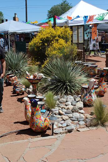
After lunch we went
to an outdoor market/art fair/jewelry show featuring southwestern
colors and items. The weather was Albuquerque perfect. 75 degrees,
bright sun lightly filtered since there was 5,500' less atmosphere to
skim out UV rays than we are used to in Florida and drier than
British humor. Here are a few pics of that featuring brightly painted ceramic pieces.


So, tomorrow is
Mother's Day. I wish a happy one to any mothers reading this –
especially my own in the Pennsylvania hills which we plan to invade
on our next excursion across America this summer. Mrs. C' and I plan
to explore Santa Fe tomorrow since we have another day without
hitching and rolling. Tune in for a summary of that adventure
tomorrow.
Good night.
SC'


