After a few days on the North Carolina coast it seems like a good time to summarize our experience and perspectives on this place. A big part of our plan for this trip was the path along the Outer Banks and the the Southeastern North Carolina Coast. Now that we are in South Carolina, that part of the trip is complete.
So, let's trace the route we took over the past several days beginning Sunday morning in Virginia and completing this afternoon at Huntington Beach State Park in Murrells Inlet, South Carolina. It's back to Google Maps: SilverCliche' Route through North Carolina
The first point to observe about that route is the nature of the coast itself. Having flown over this area countless times in my life (especially the route from Washington DC to Florida) if you are on the left side of the airplane heading south or the right side heading north it is impossible to miss the succession of capes along the NC coast. On this trip, and with the map above, it is easy to see each and to name them, They form two major scalloped shapes with three points. From north to south those points are: Cape Hatteras, Cape Lookout and Cape Fear (that's right... like the movie). Of the three, we only actually reached Cape Hatteras on this trip, but we came close to the others on the route.
This trip had several distinct segments. In order from north to south:
- The transition to the beach: Leaving the Virginia coast we entered North Carolina
- The commercial Outer Banks: The north end of the Outer Banks was a commercial vacation zone. Towns like Nags Head, Kitty Hawk and Kill Devil Hills featured high density residential development, cheap national hotel chains on the beach and every imaginable fast food joint that are (or should be) in the cross-hairs of the First Lady's healthy eating campaign.
- The unspoiled Outer Banks: Once the Cape Hatteras National Seashore begins south of Nags Head, the world changes. Although interrupted occasionally by villages, the majority of this area is unpopulated and can be accessed by visitors at limited points or with off road vehicle permits.At this time of year it was hardly used and one of the few places I've seen on earth where it is actually possible to have a beach to one's self with nobody else in sight.
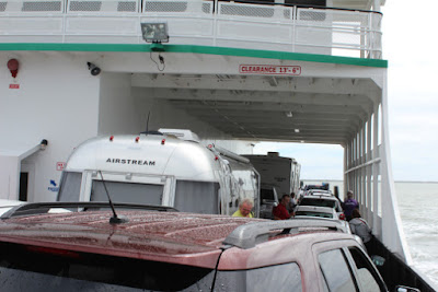
- The Sounds: The sheer size of Pamlico Sound which creates the Outer Banks surprised me. The distance from Hatteras to the mainland is significant enough to make it fell more like an isolated land than a part of a US State. Smaller, but as important, Albemarle Sound is also a significant body of water to the north of Pamlico. Here we are at sound yesterday returning from Ocracoke:
- The coastal grasslands: As we left the ferry yesterday and approached Cape Lookout we drove through mile after mile or coastal grasslands. At one point the road was followed on each side by canals that were 10-20' wide and flooded to within a foot or so of the elevation of the road. Beyond the canals were thousands of acres of grass. I commented to Mrs. C' "this area has more nothing than anyplace we've seen since Wyoming". It was impressive. Here's a closeup of some of the grass and the water that surrounds it:
- The transportation, industrial and military zone: After 30 minutes or so of driving through grass and swamps yesterday we came to serious civilization of the industrial type. Most significantly we passed through Morehead City which is located where several rivers (significantly the Newport and North) and larger bodies of water (Back Sound, Bogue Sound that the Atlantic Ocean) all come together. The benefit of that geography is evident in the development of Morehead City and its transportation activies. Today we also passed near Wilmington which is slightly less fortunate in the number of bodies of water that come together but is am economic hub none-the-less.
- The low key coast transition back to vacationland: After passing Wilmington heading south there is a transition from economic activity to low key towns and vacation areas toward South Carlina. This change is foreshadowed by a place between Morehead City and Wilmington where people go to spend time in the sun and nature, but not vacation. Camp Lejeune, a major base for the US Marine Corps. Out trip today included a stop in Calabash, NC. Calabash is renowned for its seafood -- especially fresh seafood that is breaded with a corn meal mixture and fried. Of course we sampled some. It did not disappoint. Here is a picture of the dock outside the restaurant where we ate (outdoors on picnic tables):

At about 5:00 this afternoon we crossed into South Carolina. The first things we noticed were 1.) the traffic (even on a Wednesday in late September) was heavy near Myrtle Beach 2.) the gas prices were all below $2 even at national brand stations. Some off brand was under $1.90... the lowest of our trip and 3. Back to commercial vacationland. Myrtle Beach ranks up there with Kissimmee, FL and Pigeon Forge, TN a major center for the tee-shirt and adventure mini-golf industries. We stayed there last year (once was enough!).
Tomorrow its on through Charleston and to Hunting Island State Park, SC. That will place us near Hilton Head, SC and Savannah, GA.
Later!
SC'


No comments:
Post a Comment